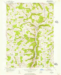
1954 Map of Gillett
USGS Topo · Published 1956About this map
Gillett and the surrounding valley of South Creek anchor this mid-century portrait of northern Bradford County, just south of the New York state line. The Pennsylvania railroad corridor defines the central north-south axis of the landscape, threading through small railside communities like Fassett and Snedekerville. The surrounding hills are marked by a pattern of upland farming and family landmarks, including Baker Hill and Rowley Hill, reflecting a rural economy established long before the 1950s.
Find a feature on this map
31 named features on this map. Tap any name to fly to it.
Don’t see what you’re looking for? This feature index may not catch every label — zoom into the map to look around manually.
Map Details
Editions of this 1954 Gillett Map
4 editions found
Other maps of this area

1895 · Elmira
USGS Topo · 1:62,500

1902 · Waverly
USGS Topo · 1:62,500

1905 · Watkins Glen
USGS Topo · 1:125,000

1931 · Troy
USGS Topo · 1:48,000

1938 · Troy
USGS Topo · 1:62,500

1939 · Sayre
USGS Topo · 1:62,500

1942 · Sayre
USGS Topo · 1:62,500

1948 · Sayre
USGS Topo · 1:62,500

1950 · Elmira
USGS Topo · 1:250,000

1953 · Roseville
USGS Topo · 1:24,000
Featured Places
- Springfield Township, PA
- South Creek Township, PA
- Waterloo, Wells Township
- Columbia Township, PA
- Wells Township, PA