
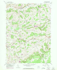
1953 Map of Roseville
USGS Topo · Published 1954About this map
Roseville (Rutland PO) serves as a primary local hub at the intersection of rural townships in northern Pennsylvania, situated near the headwaters of Mill Creek. This 1950s survey captures the region's mid-century landscape, characterized by small dispersed settlements and a network of country churches like Bakersburg Ch and Elk Run Ch. The Roosevelt Highway cuts across the center of the sheet, providing a vital artery through the agricultural terrain of Rutland and Sullivan townships. Higher elevations are marked by distinctive landmarks such as Benson Knob and King Hill, while the southeast is dominated by the broad plateau of Armenia Mtn. Genealogists will find particular value in the placement of small family or community burial grounds, including Smith Cem and Grey Valley Cem, which remain anchored to the landscape alongside old schools and post offices.
Find a feature on this map
27 named features on this map. Tap any name to fly to it.
Don’t see what you’re looking for? This feature index may not catch every label — zoom into the map to look around manually.
Map Details
Editions of this 1953 Roseville Map
2 editions found
Other maps of this area

1900 · Tioga
USGS Topo · 1:62,500

1902 · Tioga
USGS Topo · 1:62,500

1925 · Blossburg
USGS Topo · 1:62,500

1927 · Blossburg
USGS Topo · 1:62,500

1931 · Troy
USGS Topo · 1:48,000

1938 · Troy
USGS Topo · 1:62,500

1942 · Canton
USGS Topo · 1:62,500

1944 · Blossburg
USGS Topo · 1:62,500

1944 · Canton
USGS Topo · 1:62,500

1954 · Williamsport
USGS Topo · 1:250,000