1990s Maps of Boggs Township, Pennsylvania
Explore 4 historic maps of Boggs Township from the 1990s. These maps offer a rare glimpse into what life looked like during the 1990s — showing old roads, neighborhoods, homes, and landmarks that have changed or disappeared over time.
Whether you're researching your family's past, planning a metal detecting trip, or studying how Boggs Township's landscape evolved across the 1990s, these high-resolution maps are a powerful tool for exploring the history of this region.
- Focus on a specific era: All maps on this page are from the 1990s, giving you a focused view of this time period.
- See what’s changed: Compare century-old streets, trails, and buildings to today's modern landscape using overlays and satellite layers.
- Research with precision: Use these maps for genealogy, historical research, land use analysis, or educational projects.
- View, download, or print: Maps are fully viewable online in high resolution, and can be downloaded or printed for your own records.
Start exploring Boggs Township's history through authentic maps from the 1990s. This is your window into the past.
Boggs Township, PA maps
(4)- 1995 Map of Snow Shoe SE, 1999 Print
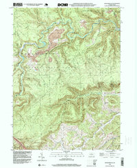 1995 Snow Shoe SE1999 Print · USGSThe rugged coal and timber lands of Centre County are captured here in the mid-1990s. Local researchers can trace the industrial footprint of Strip Mines and Tipples near Kato or locate family roots at Summit Hill Cem.
 - 1996 Map of Snow Shoe, 1999 Print
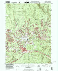 1996 Snow Shoe1999 Print · USGSCentre County's rugged plateau is captured here in the mid-1990s, showcasing the intersection of industrial coal mining and deep forest conservation. Researchers can trace family roots in settlements like Snow Shoe and Clarence, or locate landmarks such as St Michaels Cem and the Beech Creek Lodge.
 - 1998 Map of Bear Knob, 1999 Print
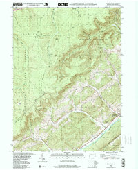 1998 Bear Knob1999 Print · USGSCentre County's rugged ridge-and-valley landscape is captured here in the late nineties, featuring the community of Unionville at the base of Bald Eagle Mountain. Researchers can trace the Old RR Grade or locate family sites at Oak Ridge Cem and the rural Dicks Run Ch.
 - 1998 Map of Bellefonte, 1999 Print
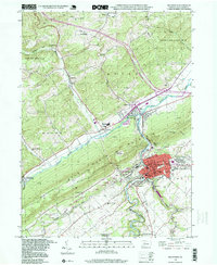 1998 Bellefonte1999 Print · USGSBellefonte and the Nittany Valley come into sharp focus in the late nineties, documenting the area's industrial footprint and mountain terrain. Trace local history through family-named sites like Trcziyulny Cem, the rural Advent Ch, and the grounds of Fishermans Paradise.
End of results
Showing maps 1-4 of 4
Top cities near Boggs Township
- State College historical maps
- Bellefonte historical maps
- Pleasant Gap historical maps
- Houserville historical maps
- Milesburg historical maps
- Centre Hall historical maps
See more
Top neighborhoods of Boggs Township
- Rhoads historical maps
- Yarnell historical maps
- Central City historical maps
- Dry Top historical maps
- Fetzertown historical maps
- Gum Stump historical maps
See more
Frequently asked questions
- What are the different types of historical maps available for Boggs Township?
- What is the oldest map of Boggs Township?
- Where can I purchase historical maps of Boggs Township for my home or office?
- Where can I download high-res historical maps of Boggs Township?
- Are there historical topographic maps available for Boggs Township?
- Is there historical aerial imagery available for Boggs Township?
- Where are historical maps of Boggs Township sourced from?