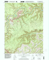
1995 Map of Snow Shoe SE
USGS Topo · Published 1999About this map
Sproul State Forest dominates this landscape in central Pennsylvania, where the borders of Burnside, Snow Shoe, Curtin, and Boggs townships meet. The terrain is defined by the winding course of Beech Creek and its many tributaries, such as Eddy Lick Run and Hayes Run. Industrial activity is evident throughout the northern reaches, where several Strip Mines and a Tipple are located near the remote settlement of Kato.
Find a feature on this map
47 named features on this map. Tap any name to fly to it.
Don’t see what you’re looking for? This feature index may not catch every label — zoom into the map to look around manually.
Map Details
Editions of this 1995 Snow Shoe SE Map
This is the sole edition of this map. No revisions or reprints were ever made.
Other maps of this area

1908 · Bellefonte
USGS Topo · 1:62,500

1909 · Bellefonte
USGS Topo · 1:62,500

1921 · Howard
USGS Topo · 1:48,000

1923 · Howard
USGS Topo · 1:62,500

1924 · Centre Hall
USGS Topo · 1:62,500

1928 · Snow Shoe
USGS Topo · 1:48,000

1929 · Centre Hall
USGS Topo · 1:62,500

1931 · Show Shoe
USGS Topo · 1:62,500

1943 · Lewistown
USGS Topo · 1:125,000

1950 · Harrisburg
USGS Topo · 1:250,000