2020s Maps of Bell Township, Pennsylvania
Explore 4 historic maps of Bell Township from the 2020s. These maps offer a rare glimpse into what life looked like during the 2020s — showing old roads, neighborhoods, homes, and landmarks that have changed or disappeared over time.
Whether you're researching your family's past, planning a metal detecting trip, or studying how Bell Township's landscape evolved across the 2020s, these high-resolution maps are a powerful tool for exploring the history of this region.
- Focus on a specific era: All maps on this page are from the 2020s, giving you a focused view of this time period.
- See what’s changed: Compare century-old streets, trails, and buildings to today's modern landscape using overlays and satellite layers.
- Research with precision: Use these maps for genealogy, historical research, land use analysis, or educational projects.
- View, download, or print: Maps are fully viewable online in high resolution, and can be downloaded or printed for your own records.
Start exploring Bell Township's history through authentic maps from the 2020s. This is your window into the past.
Bell Township, PA maps
(4)- 2023 Map of Westover, 2023 Print
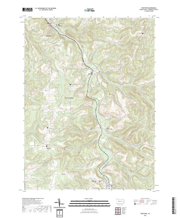 2023 Westover2023 Print · USGSClearfield County's rural character is preserved in this study of the upper Chest Creek valley in the twenty-first century. Genealogists can locate family burial sites at Westover Cem, Harmony Cem, and New Washington Cem.
 - 2023 Map of Mahaffey, 2023 Print
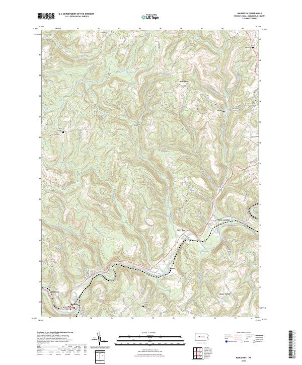 2023 Mahaffey2023 Print · USGSClearfield County's river valleys and ridgelines are shown in detail during the early 2020s, centered on the winding path of the West Branch Susquehanna River. Genealogists and historians can locate rural landmarks like Banner Ridge Cem, the crossroads at Bells Landing, and the settlement of Mahaffey.
 - 2023 Map of Burnside, 2023 Print
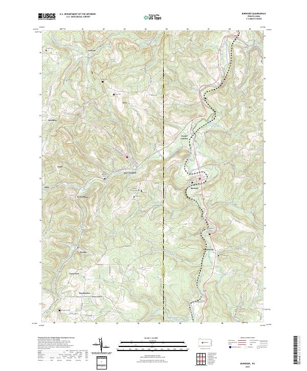 2023 Burnside2023 Print · USGSThe Clearfield and Indiana county line comes alive in this survey of the upper Susquehanna valley. Local historians can trace the family legacies left at Sunderland Cem, Saint Michaels Cem, and within the small settlements of Burnside and Arcadia.
 - 2023 Map of McGees Mills, 2023 Print
 2023 McGees Mills2023 Print · USGSThe tri-county borderlands of Jefferson, Clearfield, and Indiana counties appear in contemporary detail. Family historians can trace numerous remote burial sites such as Slimmer Family Cem and Old Cumberland Cem near the banks of Clover Run.
End of results
Showing maps 1-4 of 4
Top cities near Bell Township
- Sandy Township historical maps
- DuBois historical maps
- Winslow historical maps
- Reynoldsville historical maps
- Curwensville historical maps
- Beccaria Township historical maps
See more
Top neighborhoods of Bell Township
- McGees Mills historical maps
- Newtonburg historical maps
- Clover Run historical maps
- Middleton historical maps
- Ostend historical maps
- Bethlehem historical maps
Frequently asked questions
- What are the different types of historical maps available for Bell Township?
- What is the oldest map of Bell Township?
- Where can I purchase historical maps of Bell Township for my home or office?
- Where can I download high-res historical maps of Bell Township?
- Are there historical topographic maps available for Bell Township?
- Is there historical aerial imagery available for Bell Township?
- Where are historical maps of Bell Township sourced from?