1940s Maps of Morris Township, Pennsylvania
Explore 3 historic maps of Morris Township from the 1940s. These maps offer a rare glimpse into what life looked like during the 1940s — showing old roads, neighborhoods, homes, and landmarks that have changed or disappeared over time.
Whether you're researching your family's past, planning a metal detecting trip, or studying how Morris Township's landscape evolved across the 1940s, these high-resolution maps are a powerful tool for exploring the history of this region.
- Focus on a specific era: All maps on this page are from the 1940s, giving you a focused view of this time period.
- See what’s changed: Compare century-old streets, trails, and buildings to today's modern landscape using overlays and satellite layers.
- Research with precision: Use these maps for genealogy, historical research, land use analysis, or educational projects.
- View, download, or print: Maps are fully viewable online in high resolution, and can be downloaded or printed for your own records.
Start exploring Morris Township's history through authentic maps from the 1940s. This is your window into the past.
Morris Township, PA maps
(3)- 1945 Map of Philipsburg
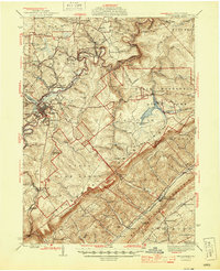 1945 Philipsburg1945 Print · USGSPhilipsburg and the central Pennsylvania coal country are shown here in the mid-1940s as industry and recreation shaped the landscape. Researchers can trace the legacy of the NEW YORK CENTRAL railroad, find the site of Martha Furnace, or locate rural schools like Hope Sch and Black Oak Sch.
 - 1945 Map of Wallaceton, 1956 Print
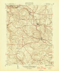
 1945 Wallaceton1956 Print · USGSClearfield County's upland mining and rail corridor is captured here at the end of the war. Genealogists and researchers can trace family landmarks like Salem Ch, Eagle Eye Sch, and the junction at Wallaceton before modern development changed the landscape.4 unique versions available
 - 1946 Map of Wallaceton
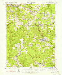
 1946 Wallaceton1946 Print · USGSClearfield County at the close of the 1940s is shown here as a series of tight-knit townships and rural school districts. Researchers can trace the exact locations of many local landmarks including West Decatur P O, Eagle Eye Sch, and Salem Ch.2 unique versions available
End of results
Showing maps 1-3 of 3
Top cities near Morris Township
- Clearfield historical maps
- Philipsburg historical maps
- Beccaria Township historical maps
- Warriors Mark Township historical maps
- Graham historical maps
- Bigler historical maps
See more
Top neighborhoods of Morris Township
- Troy historical maps
- Allport historical maps
- Hawk Run historical maps
- Morrisdale historical maps
- Munson historical maps
- Oak Grove historical maps
See more
Frequently asked questions
- What are the different types of historical maps available for Morris Township?
- What is the oldest map of Morris Township?
- Where can I purchase historical maps of Morris Township for my home or office?
- Where can I download high-res historical maps of Morris Township?
- Are there historical topographic maps available for Morris Township?
- Is there historical aerial imagery available for Morris Township?
- Where are historical maps of Morris Township sourced from?