1800s (19th Century) Maps of Columbia County, Pennsylvania
Explore 9 historic maps of Columbia County from the 1800s (19th Century). These maps offer a rare glimpse into what life looked like during the 1800s — showing old roads, neighborhoods, homes, and landmarks that have changed or disappeared over time.
Whether you're researching your family's past, planning a metal detecting trip, or studying how Columbia County's landscape evolved across the 1800s, these high-resolution maps are a powerful tool for exploring the history of this region.
- Focus on a specific era: All maps on this page are from the 1800s, giving you a focused view of this time period.
- See what’s changed: Compare century-old streets, trails, and buildings to today's modern landscape using overlays and satellite layers.
- Research with precision: Use these maps for genealogy, historical research, land use analysis, or educational projects.
- View, download, or print: Maps are fully viewable online in high resolution, and can be downloaded or printed for your own records.
Start exploring Columbia County's history through authentic maps from the 1800s. This is your window into the past.
Columbia County, PA maps
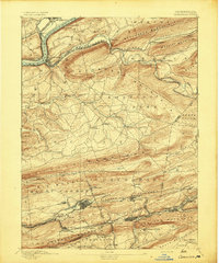
(9)- 1889 Map of Catawissa, 1954 Print
 1889 Catawissa1954 Print · USGSThe anthracite coal region and Susquehanna River valley come alive in this late 19th-century survey. Genealogists and historians can trace the early rail networks of the Philadelphia and Reading Railroad connecting industrial hubs like Centralia, Mount Carmel, and Ashland.
 - 1892 Map of Catawissa
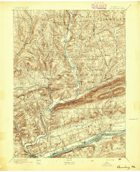
 1892 Catawissa1892 Print · USGSThe Pennsylvania anthracite region comes into focus during the late nineteenth-century coal boom. Genealogists and historians can trace rail-centered towns like Centralia, Ashland, and Mount Carmel alongside the historic Bloomsburg Ferry.
 - 1892 Map of Shamokin
 1892 Shamokin1892 Print · USGSNorthumberland and Montour Counties are shown here during their industrial prime, when coal and rail shaped every valley. Researchers can trace the early footprints of Shamokin and Danville or locate smaller rail stops like Wolverton Station and Paxinos.
 - 1892 Map of Mahanoy
 1892 Mahanoy1892 Print · USGSSchuylkill and Luzerne counties are captured here at a peak of industrial development during the 1890s coal era. Researchers can trace the massive rail networks serving Shenandoah, Mahanoy City, and lost junctions like Silver Brook Junction.
 - 1893 Map of Shamokin
 1893 Shamokin1893 Print · USGSNorthumberland County's coal-and-rail landscape is captured here during the peak of its industrial development in the late nineteenth century. Researchers can trace the extensive rail networks serving settlements like Shamokin, Danville, and Trevorton, alongside early infrastructure like the Weigh Scale.6 unique versions available
 - 1893 Map of Mahanoy, 1898 Print
 1893 Mahanoy1898 Print · USGSSchuylkill and Luzerne counties are shown at the height of the coal era, revealing a landscape etched by mining and rail commerce. Genealogists and industrial historians can trace the specific neighborhoods of Shenandoah, Mahanoy City, and the railway junctions at Tamanend and Delano.7 unique versions available
 - 1894 Map of Catawissa
 1894 Catawissa1894 Print · USGSPennsylvania's anthracite coal region and the Susquehanna valley appear here in the late nineteenth century, defined by a massive expansion of rail and ridge-top settlements. Researchers can trace old transit lines like the Lehigh Valley Railroad through Centralia or locate early rural hubs like Mifflin X Roads.6 unique versions available
 - 1894 Map of Shickshinny
 1894 Shickshinny1894 Print · USGSLuzerne County at the height of the coal and canal era reveals a landscape shaped by river transport and mountain ridges. Trace the remnants of the Pennsylvania Canal and locate long-standing river crossings like Hicks Ferry and Beach Haven Ferry.6 unique versions available
 - 1894 Map of Bloomsburg
 1894 Bloomsburg1894 Print · USGSThe Sesquehanna River valley in the late nineteenth century shows a landscape shaped by competing rail and water transport. Genealogists can trace family roots in river towns like Mifflinville or follow the mills and stations along Fishing Creek and the Sullivan RR.6 unique versions available
End of results
Showing maps 1-9 of 9
Top cities of Columbia County
- Bloomsburg historical maps
- Berwick historical maps
- Greenwood Township historical maps
- North Centre Township historical maps
- Millville historical maps
- Benton historical maps
See more
Frequently asked questions
- What are the different types of historical maps available for Columbia County?
- What is the oldest map of Columbia County?
- Where can I purchase historical maps of Columbia County for my home or office?
- Where can I download high-res historical maps of Columbia County?
- Are there historical topographic maps available for Columbia County?
- Is there historical aerial imagery available for Columbia County?
- Where are historical maps of Columbia County sourced from?