1960s Maps of Columbia County, Pennsylvania
Explore 14 historic maps of Columbia County from the 1960s. These maps offer a rare glimpse into what life looked like during the 1960s — showing old roads, neighborhoods, homes, and landmarks that have changed or disappeared over time.
Whether you're researching your family's past, planning a metal detecting trip, or studying how Columbia County's landscape evolved across the 1960s, these high-resolution maps are a powerful tool for exploring the history of this region.
- Focus on a specific era: All maps on this page are from the 1960s, giving you a focused view of this time period.
- See what’s changed: Compare century-old streets, trails, and buildings to today's modern landscape using overlays and satellite layers.
- Research with precision: Use these maps for genealogy, historical research, land use analysis, or educational projects.
- View, download, or print: Maps are fully viewable online in high resolution, and can be downloaded or printed for your own records.
Start exploring Columbia County's history through authentic maps from the 1960s. This is your window into the past.
Columbia County, PA maps
(14)- 1960 Map of Williamsport
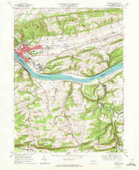
 1960 Williamsport1960 Print · USGSNorth-central Pennsylvania in the mid-twentieth century was a vital corridor of rail and river industry stretching from the New York line to the coal regions. Genealogists can trace the rail networks of the Pennsylvania RR and Lehigh Valley RR connecting towns like Williamsport, Towanda, and Lock Haven.
 - 1961 Map of Harrisburg
 1961 Harrisburg1961 Print · USGSCentral Pennsylvania is shown at a mid-century peak of industrial and military activity, from the Susquehanna water gaps to the fertile Dutch Country. Genealogists and historians can trace the rail corridors of the Pennsylvania RR and find landmarks like Carlisle Barracks or the Anthracite Coal Fields.2 unique versions available
 - 1962 Map of Williamsport, 1966 Print
 1962 Williamsport1966 Print · USGSNorth-central Pennsylvania was a landscape of industrial river hubs and vast state woodlands in the early sixties. Researchers can trace the path of the Pennsylvania Railroad through Williamsport and explore the remote reaches of Bucktail State Park.5 unique versions available
 - 1964 Map of Harrisburg
 1964 Harrisburg1964 Print · USGSCentral Pennsylvania in the mid-fifties reveals a landscape shaped by ridge-and-valley geology and critical Cold War infrastructure. Researchers can trace the massive Indiantown Gap Military Reservation or the rail corridors of the Pennsylvania RR and Reading RR.
 - 1965 Map of Williamsport
 1965 Williamsport1965 Print · USGSNorth-central Pennsylvania in the mid-1960s is defined by the industrial river towns and vast timberlands of the Allegheny Plateau. Researchers can trace historic rail lines like the Erie Lackawanna and Reading as they thread through Williamsport, Lock Haven, and Jersey Shore.
 - 1966 Map of Williamsport
 1966 Williamsport1966 Print · USGSThe Susquehanna Valley was a hub of transit and industry in the mid-seventies, where the river's West Branch connected major college towns and timberlands. Researchers can trace historical rail lines like the Reading or locate regional landmarks from Jersey Shore to Ricketts Glen State Park.
 - 1968 Map of Millville, 1972 Print
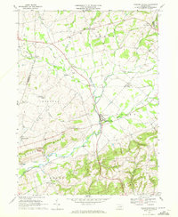
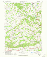 1968 Millville1972 Print · USGSMillville and the surrounding Columbia County townships appear here in the late sixties as a traditional landscape of creek-side hamlets and ridge-top farms. Genealogists can trace family footprints at Longs Ch Cem, St Johns Ch, and old settlements like Jerseytown or Eyers Grove.3 unique versions available
 - 1968 Map of Hughesville, 1972 Print
 1968 Hughesville1972 Print · USGSHughesville and its rural surroundings in Lycoming County appear here during the late sixties as a network of ridge-top farms and valley hamlets. Researchers can trace local heritage through sites like Moreland Community Ch, Pleasant Hill Cem, and the old Fairgrounds.3 unique versions available
 - 1968 Map of Lairdsville, 1972 Print
 1968 Lairdsville1972 Print · USGSThe rural borders of Lycoming and Columbia counties come into focus in the late sixties, showing a landscape of upland ridges and creek-side settlements. Genealogists can trace family roots through sites like Salem Ch, Gardner Cem, and the historic Shoemaker Bridge.3 unique versions available
 - 1969 Map of Shamokin, 1972 Print
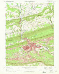 1969 Shamokin1972 Print · USGSNorthumberland County coal country is captured here in the late sixties, showing the dense industrial and residential growth of Shamokin and its surrounding boroughs. Trace the extensive rail networks of the Penn Central and find local landmarks like the Shamokin State Hospital and Kemp Stadium.2 unique versions available
 - 1969 Map of Danville, 1972 Print
 1969 Danville1972 Print · USGSDanville and the Susquehanna River valley are shown in the late sixties as the region's healthcare and rail legacy remained central to local life. Genealogists and historians can trace the foundations of Geisinger Hospital, find rural landmarks like the Riegel Covered Bridge, or locate family sites near Mechanicsville and Knoebels Grove.4 unique versions available
 - 1969 Map of Washingtonville, 1972 Print
 1969 Washingtonville1972 Print · USGSMontour County agriculture and rural life are preserved here in the late sixties as the region maintained its traditional crossroad hamlets. Researchers can locate family landmarks like the Billmeyer Cem, the historic Covered Bridge, and schools including DeLong Memorial Sch.4 unique versions available
 - 1969 Map of Elk Grove, 1973 Print
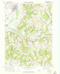
 1969 Elk Grove1973 Print · USGSSullivan and Columbia counties appear at a quiet moment in the late sixties, showing the small creek-side settlements that define the Endless Mountains. Researchers can trace the Old Railroad Grade or locate family sites near Elk Grove, Central, and Brandon Ch.3 unique versions available
 - 1969 Map of Red Rock, 1973 Print
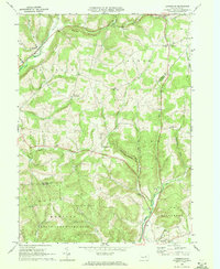
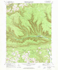
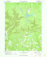 1969 Red Rock1973 Print · USGSThe high plateau of the Endless Mountains is captured in the late sixties, showing the Cold War presence of the Benton Air Force Station. Genealogists and historians can trace the remote settlements of Jamison City, Central, and Mossville alongside the waterfalls of Ricketts Glen State Park.4 unique versions available
End of results
Showing maps 1-14 of 14
Top cities of Columbia County
- Bloomsburg historical maps
- Berwick historical maps
- Greenwood Township historical maps
- North Centre Township historical maps
- Millville historical maps
- Benton historical maps
See more
Frequently asked questions
- What are the different types of historical maps available for Columbia County?
- What is the oldest map of Columbia County?
- Where can I purchase historical maps of Columbia County for my home or office?
- Where can I download high-res historical maps of Columbia County?
- Are there historical topographic maps available for Columbia County?
- Is there historical aerial imagery available for Columbia County?
- Where are historical maps of Columbia County sourced from?