1990s Maps of Columbia County, Pennsylvania
Explore 3 historic maps of Columbia County from the 1990s. These maps offer a rare glimpse into what life looked like during the 1990s — showing old roads, neighborhoods, homes, and landmarks that have changed or disappeared over time.
Whether you're researching your family's past, planning a metal detecting trip, or studying how Columbia County's landscape evolved across the 1990s, these high-resolution maps are a powerful tool for exploring the history of this region.
- Focus on a specific era: All maps on this page are from the 1990s, giving you a focused view of this time period.
- See what’s changed: Compare century-old streets, trails, and buildings to today's modern landscape using overlays and satellite layers.
- Research with precision: Use these maps for genealogy, historical research, land use analysis, or educational projects.
- View, download, or print: Maps are fully viewable online in high resolution, and can be downloaded or printed for your own records.
Start exploring Columbia County's history through authentic maps from the 1990s. This is your window into the past.
Columbia County, PA maps
(3)- 1994 Map of Danville, 1996 Print
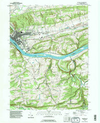 1994 Danville1996 Print · USGSDanville and the winding Susquehanna River corridor appear in the mid-1990s, revealing a landscape of ridge-top farms and riverbank industry. Genealogists can locate family landmarks like Wilson Cem, Straub Ch, and the grounds of the State Hospital.
 - 1995 Map of Red Rock, 1998 Print
 1995 Red Rock1998 Print · USGSThe high plateau where Sullivan, Luzerne, and Columbia counties converge was a hub of timbering and mountain recreation in the mid-nineties. Trace the path of the Old Railroad Grade or locate the Covered Bridge near historical settlements like Jamison City and Tri Mills.
 - 1999 Map of Bloomsburg, 2001 Print
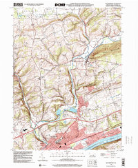 1999 Bloomsburg2001 Print · USGSThe Susquehanna River valley near Bloomsburg is seen here in the late twentieth century as a hub of education and industry. Researchers can trace the layout of the State Teachers College, local churches like Canby Ch, and the historic community of Light Street.
End of results
Showing maps 1-3 of 3
Top cities of Columbia County
- Bloomsburg historical maps
- Berwick historical maps
- Greenwood Township historical maps
- North Centre Township historical maps
- Millville historical maps
- Benton historical maps
See more
Frequently asked questions
- What are the different types of historical maps available for Columbia County?
- What is the oldest map of Columbia County?
- Where can I purchase historical maps of Columbia County for my home or office?
- Where can I download high-res historical maps of Columbia County?
- Are there historical topographic maps available for Columbia County?
- Is there historical aerial imagery available for Columbia County?
- Where are historical maps of Columbia County sourced from?