1900-1909 Maps of Crawford County, Pennsylvania
Explore 9 historic maps of Crawford County from 1900-1909. These maps offer a rare glimpse into what life looked like during the 1900s — showing old roads, neighborhoods, homes, and landmarks that have changed or disappeared over time.
Whether you're researching your family's past, planning a metal detecting trip, or studying how Crawford County's landscape evolved across the 1900s, these high-resolution maps are a powerful tool for exploring the history of this region.
- Focus on a specific era: All maps on this page are from the 1900s, giving you a focused view of this time period.
- See what’s changed: Compare century-old streets, trails, and buildings to today's modern landscape using overlays and satellite layers.
- Research with precision: Use these maps for genealogy, historical research, land use analysis, or educational projects.
- View, download, or print: Maps are fully viewable online in high resolution, and can be downloaded or printed for your own records.
Start exploring Crawford County's history through authentic maps from the 1900s. This is your window into the past.
Crawford County, PA maps
(9)- 1900 Map of Girard
 1900 Girard1900 Print · USGSNorthwestern Pennsylvania at the dawn of the twentieth century was a vital rail corridor defined by the shoreline of Lake Erie. You can trace the path of historic rail lines through Thornton Junction and locate vanished local landmarks like Lundys Lane and Paperville.5 unique versions available
 - 1905 Map of Andover
 1905 Andover1905 Print · USGSAshtabula County and the Pennsylvania border are shown here at the height of the steam era, before modern highways transformed these rural townships. Genealogists and researchers can locate early congregations like South Denmark Church and trace the paths of the Cooperage Co RR or the Lake Shore and Michigan Southern Railroad.3 unique versions available
 - 1906 Map of Conneaut, 1943 Print
 1906 Conneaut1943 Print · USGSAshtabula County's industrial and rural landscape is caught at a pivotal moment as the rail network expanded toward the Lake Erie shoreline. Researchers can trace early township life in Monroe Center or follow the heavy rail traffic through Conneaut and Kingsville Station.2 unique versions available
 - 1906 Map of Linesville, 1958 Print
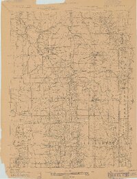
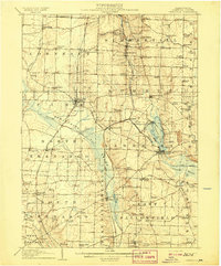
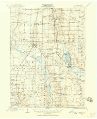 1906 Linesville1958 Print · USGSCrawford County at the turn of the century is defined by its massive wetland systems and the busy rail corridors crossing the Pymatuning Swamp. Researchers can trace the early layout of Exposition Park on Conneaut Lake or locate old rural centers like Espyville Station and Center Road Station.
 - 1907 Map of Andover
 1907 Andover1907 Print · USGSThe Ohio-Pennsylvania borderlands near Andover are captured here during a period of significant railway expansion. Local historians can trace early mail routes and church sites like the Williamsfield P O, South Denmark Church, and the vanished crossroads of Padanaram.4 unique versions available
 - 1907 Map of Kinsman, 1940 Print
 1907 Kinsman1940 Print · USGSEastern Trumbull County thrived at the start of the century as a vital crossroads of Ohio and Pennsylvania rail lines. Local historians can trace the foundations of Kinsman, Orangeville, and the remote State Line Church during the height of the steam rail era.2 unique versions available
 - 1908 Map of Shenango
 1908 Shenango1908 Print · USGSMercer County at the height of the steam era reveals a landscape defined by an intricate network of competing rail lines and rural hamlets. Genealogists can trace family roots through numerous country schools like Ray School and churches such as Goodhope Church.5 unique versions available
 - 1908 Map of Linesville
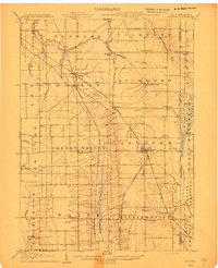
 1908 Linesville1908 Print · USGSCrawford County at the turn of the century is a landscape of expansive wetlands and rising rail towns. Genealogists can trace family roots through numerous country schools like Brush College School or locate the historic Steamboat Route on Conneaut Lake.4 unique versions available
 - 1909 Map of Franklin, 1956 Print
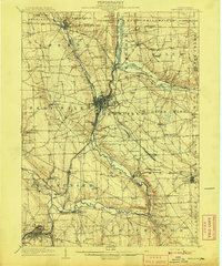
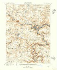 1909 Franklin1956 Print · USGSVenango County at the dawn of the twentieth century is a landscape defined by the deep meanders of the Allegheny River and a dense network of competing railroads. Genealogists can trace rural life through numerous landmarks like Five Points School, Hickory Grove Church, and the State Institute for Feeble Minded at Polk.2 unique versions available
End of results
Showing maps 1-9 of 9
Top cities of Crawford County
- Meadville historical maps
- Titusville historical maps
- Cambridge Springs historical maps
- Spring Township historical maps
- Linesville historical maps
- Cochranton historical maps
See more
Frequently asked questions
- What are the different types of historical maps available for Crawford County?
- What is the oldest map of Crawford County?
- Where can I purchase historical maps of Crawford County for my home or office?
- Where can I download high-res historical maps of Crawford County?
- Are there historical topographic maps available for Crawford County?
- Is there historical aerial imagery available for Crawford County?
- Where are historical maps of Crawford County sourced from?