1990s Maps of Crawford County, Pennsylvania
Explore 5 historic maps of Crawford County from the 1990s. These maps offer a rare glimpse into what life looked like during the 1990s — showing old roads, neighborhoods, homes, and landmarks that have changed or disappeared over time.
Whether you're researching your family's past, planning a metal detecting trip, or studying how Crawford County's landscape evolved across the 1990s, these high-resolution maps are a powerful tool for exploring the history of this region.
- Focus on a specific era: All maps on this page are from the 1990s, giving you a focused view of this time period.
- See what’s changed: Compare century-old streets, trails, and buildings to today's modern landscape using overlays and satellite layers.
- Research with precision: Use these maps for genealogy, historical research, land use analysis, or educational projects.
- View, download, or print: Maps are fully viewable online in high resolution, and can be downloaded or printed for your own records.
Start exploring Crawford County's history through authentic maps from the 1990s. This is your window into the past.
Crawford County, PA maps
(5)- 1994 Map of Andover, 1997 Print
 1994 Andover1997 Print · USGSAshtabula County and the Pennsylvania borderlands appear here in the mid-nineties, centered on the village of Andover. Researchers can trace family history through the West Lawn and Simons cemeteries or locate recreational landmarks like the Drive-in Theater.
 - 1994 Map of Kinsman, 1997 Print
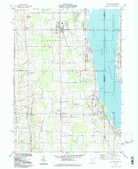
 1994 Kinsman1997 Print · USGSTrumbull County and the Pennsylvania border are captured in the late twentieth century, showing a landscape of fertile creek valleys and quiet crossroads. Trace family history at Gibson Cem, find the site of Farmdale (Kinsman Sta), or explore the Pymatuning State Wildlife Area.
 - 1994 Map of Pierpont, 1997 Print
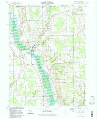
 1994 Pierpont1997 Print · USGSAshtabula County's rural borderlands remained a mosaic of energy extraction and small-town crossroads in the late twentieth century. Genealogists and historians can trace family locations through Evergreen Cem, identify old homesteads near Bushnell, or find the historic Covered Bridge on the Ashtabula River.
 - 1994 Map of Leon, 1997 Print
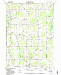
 1994 Leon1997 Print · USGSThe Ohio-Pennsylvania borderlands near the turn of the millennium retain a deep rural character centered on the Ashtabula River headwaters. Genealogists and local historians can trace family sites at Pennline Cem, Richmond Center, and the small settlement of Leon.
 - 1998 Map of Meadville, 1999 Print
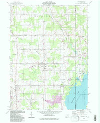
 1998 Meadville1999 Print · USGSMeadville and the French Creek valley are shown here at the close of the twentieth century, balancing industrial heritage with its role as an educational hub. Genealogists and historians can trace family sites at Littles Corners, explore the grounds of Allegheny College, and locate numerous local burials at Greendale Cem and St Agathas Cemetery.
End of results
Showing maps 1-5 of 5
Top cities of Crawford County
- Meadville historical maps
- Titusville historical maps
- Cambridge Springs historical maps
- Spring Township historical maps
- Linesville historical maps
- Cochranton historical maps
See more
Frequently asked questions
- What are the different types of historical maps available for Crawford County?
- What is the oldest map of Crawford County?
- Where can I purchase historical maps of Crawford County for my home or office?
- Where can I download high-res historical maps of Crawford County?
- Are there historical topographic maps available for Crawford County?
- Is there historical aerial imagery available for Crawford County?
- Where are historical maps of Crawford County sourced from?