1920s Maps of Crawford County, Pennsylvania
Explore 8 historic maps of Crawford County from the 1920s. These maps offer a rare glimpse into what life looked like during the 1920s — showing old roads, neighborhoods, homes, and landmarks that have changed or disappeared over time.
Whether you're researching your family's past, planning a metal detecting trip, or studying how Crawford County's landscape evolved across the 1920s, these high-resolution maps are a powerful tool for exploring the history of this region.
- Focus on a specific era: All maps on this page are from the 1920s, giving you a focused view of this time period.
- See what’s changed: Compare century-old streets, trails, and buildings to today's modern landscape using overlays and satellite layers.
- Research with precision: Use these maps for genealogy, historical research, land use analysis, or educational projects.
- View, download, or print: Maps are fully viewable online in high resolution, and can be downloaded or printed for your own records.
Start exploring Crawford County's history through authentic maps from the 1920s. This is your window into the past.
Crawford County, PA maps
(8)- 1923 Map of Meadville, 1962 Print
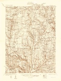
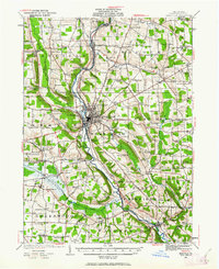 1923 Meadville1962 Print · USGSCrawford County's river valleys and rail corridors are captured here in the early 1920s, centered on the growing industrial hub of Meadville. Researchers can locate dozens of country schoolhouses like Huller School and trace the paths of the Erie R R and Perry Highway.
 - 1923 Map of Cambridge Springs, 1964 Print
 1923 Cambridge Springs1964 Print · USGSNorthwestern Pennsylvania in the 1920s reveals a landscape of rural schoolhouses and electric rail lines. Genealogists can trace family roots through numerous local landmarks like Saints Church, Carmel Cem, and the specialized Northwestern Electric railroad stops.
 - 1925 Map of Meadville
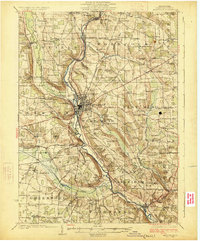 1925 Meadville1925 Print · USGSCrawford County settlements and rail corridors are captured in detail here during the mid-twenties. Genealogists can locate dozens of family-named schoolhouses and landmarks, from Booths Church to the County Farm and Frenchtown.3 unique versions available
 - 1925 Map of Cambridge Springs
 1925 Cambridge Springs1925 Print · USGSNorthwestern Pennsylvania in the mid-1920s shows a landscape of busy crossroads and river towns connected by expanding rail lines. Genealogists can locate family-named sites like Mishler Corners and dozens of country schools such as Strong School and Sedgwick School.4 unique versions available
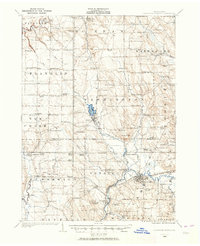
 - 1927 Map of Townville
 1927 Townville1927 Print · USGSNorthwestern Pennsylvania's rural landscape is captured here in the late 1920s, revealing a network of small townships and family settlements. Genealogists can locate family landmarks like the Donation School, Mt Hope Church, and the lakeside community at Sugar Lake.3 unique versions available
 - 1927 Map of Titusville, 1958 Print
 1927 Titusville1958 Print · USGSThe oil region of northwestern Pennsylvania is captured here in the late 1920s, centered on the industrial and rail hub of Titusville. Genealogists and researchers can locate the historic Drake Oil Well, dozens of country schools like Fink Ridge Sch, and the local Harrison Cem.3 unique versions available
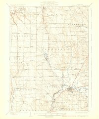
 - 1929 Map of Corry
 1929 Corry1929 Print · USGSThe industrial hub of Corry and the rural expanses of Erie and Crawford counties are captured here just before the Great Depression. Genealogists can trace family roots through numerous remote schools and churches, from Harbor Hall Ch to the tiny settlement of Hatchtown.2 unique versions available
 - 1929 Map of Union City, 1961 Print
 1929 Union City1961 Print · USGSNorthwestern Pennsylvania in the late twenties remains a landscape of busy rail junctions and crossroads hamlets like Wattsburg and Union City. Genealogists can trace family footprints across dozens of local landmarks, including the Cottage Hill Ch, Barton Sch, and Tillotson Corners.
End of results
Showing maps 1-8 of 8
Top cities of Crawford County
- Meadville historical maps
- Titusville historical maps
- Cambridge Springs historical maps
- Spring Township historical maps
- Linesville historical maps
- Cochranton historical maps
See more
Frequently asked questions
- What are the different types of historical maps available for Crawford County?
- What is the oldest map of Crawford County?
- Where can I purchase historical maps of Crawford County for my home or office?
- Where can I download high-res historical maps of Crawford County?
- Are there historical topographic maps available for Crawford County?
- Is there historical aerial imagery available for Crawford County?
- Where are historical maps of Crawford County sourced from?