1930s Maps of Elk County, Pennsylvania
Explore 7 historic maps of Elk County from the 1930s. These maps offer a rare glimpse into what life looked like during the 1930s — showing old roads, neighborhoods, homes, and landmarks that have changed or disappeared over time.
Whether you're researching your family's past, planning a metal detecting trip, or studying how Elk County's landscape evolved across the 1930s, these high-resolution maps are a powerful tool for exploring the history of this region.
- Focus on a specific era: All maps on this page are from the 1930s, giving you a focused view of this time period.
- See what’s changed: Compare century-old streets, trails, and buildings to today's modern landscape using overlays and satellite layers.
- Research with precision: Use these maps for genealogy, historical research, land use analysis, or educational projects.
- View, download, or print: Maps are fully viewable online in high resolution, and can be downloaded or printed for your own records.
Start exploring Elk County's history through authentic maps from the 1930s. This is your window into the past.
Elk County, PA maps
(7)- 1932 Map of Clearfield
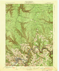 1932 Clearfield1932 Print · USGSClearfield and the West Branch of the Susquehanna are captured here in the early 1930s as a vital hub of rail and river industry. Researchers can trace ancestral locations through numerous rural landmarks like Lecontes Mills, Goshen Ch, and Mt Sinai Sch.4 unique versions available
 - 1932 Map of Penfield
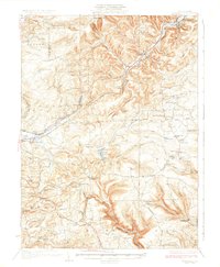 1932 Penfield1932 Print · USGSClearfield County is shown in the early thirties at a time when mountain railroads and forest management defined the region. Local historians can trace the paths of the Pennsylvania RR through Penfield or locate schools such as Coal Hill Sch and Hickory Sch.3 unique versions available
 - 1932 Map of Karthaus
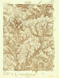
 1932 Karthaus1932 Print · USGSThe Susquehanna’s West Branch winds through Clearfield and Centre Counties in the late 1920s, a landscape shaped by the rail and timber industries. Genealogists can trace family names through dozens of rural schools and churches like Mignot Sch and Fairview Ch.3 unique versions available
 - 1934 Map of Kane
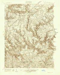
 1934 Kane1934 Print · USGSThe timber and oil lands of McKean and Elk counties are captured here in the mid-1930s as a network of railroads and pipelines. Researchers can trace family roots in settlements like De Young PO, locate CCC Camp No 7, or find the Greendale Sch.3 unique versions available
 - 1935 Map of Mt. Jewett
 1935 Mt. Jewett1935 Print · USGSElk and McKean counties at the height of the Great Depression reveal a landscape shaped by competing timber and rail interests. Researchers can trace the junction of three major railroads and find vanished operations at Burning Well and Instanter.3 unique versions available
 - 1936 Map of Marienville
 1936 Marienville1936 Print · USGSThe Pennsylvania highlands between the Clarion River and Allegheny National Forest appear here in the mid-1930s. Researchers can trace the Baltimore and Ohio RR through Marienville or locate family landmarks like Donnely Cem and Greenwood Ch.3 unique versions available
 - 1939 Map of Kane
 1939 Kane1939 Print · USGSThe northern Pennsylvania plateau in the late 1930s is a landscape of timber-towns and industrial rail sidings. Genealogists and researchers can trace the old Baltimore and Ohio line through Kane, James City, and the rural Russell City De Young P O.3 unique versions available
End of results
Showing maps 1-7 of 7
Top cities of Elk County
- Saint Marys historical maps
- Ridgway historical maps
- Johnsonburg historical maps
- Benezette Township historical maps
- Millstone Township historical maps
Frequently asked questions
- What are the different types of historical maps available for Elk County?
- What is the oldest map of Elk County?
- Where can I purchase historical maps of Elk County for my home or office?
- Where can I download high-res historical maps of Elk County?
- Are there historical topographic maps available for Elk County?
- Is there historical aerial imagery available for Elk County?
- Where are historical maps of Elk County sourced from?