1970s Maps of Elk County, Pennsylvania
Explore 5 historic maps of Elk County from the 1970s. These maps offer a rare glimpse into what life looked like during the 1970s — showing old roads, neighborhoods, homes, and landmarks that have changed or disappeared over time.
Whether you're researching your family's past, planning a metal detecting trip, or studying how Elk County's landscape evolved across the 1970s, these high-resolution maps are a powerful tool for exploring the history of this region.
- Focus on a specific era: All maps on this page are from the 1970s, giving you a focused view of this time period.
- See what’s changed: Compare century-old streets, trails, and buildings to today's modern landscape using overlays and satellite layers.
- Research with precision: Use these maps for genealogy, historical research, land use analysis, or educational projects.
- View, download, or print: Maps are fully viewable online in high resolution, and can be downloaded or printed for your own records.
Start exploring Elk County's history through authentic maps from the 1970s. This is your window into the past.
Elk County, PA maps
(5)- 1970 Map of Brandy Camp, 1972 Print
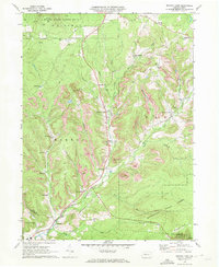 1970 Brandy Camp1972 Print · USGSElk County's coal and rail landscapes are meticulously detailed in this early 1970s survey. Researchers can trace the Erie-Lackawanna line through Brockport and locate family landmarks like Holy Cross Ch and Ridge Cem.3 unique versions available
 - 1970 Map of Kersey, 1972 Print
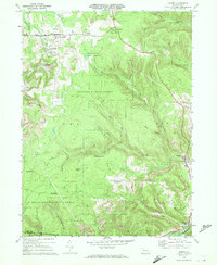 1970 Kersey1972 Print · USGSThe Elk County coal and timber country is captured here in the early seventies, showing a landscape shaped by resource extraction. Local historians can trace the Penn Central rail line and locate specific operations at Dagus Mines, Coal Hollow, and Byrnedale.3 unique versions available
 - 1970 Map of Carman, 1972 Print
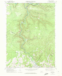 1970 Carman1972 Print · USGSElk and Jefferson counties during the 1970s show a landscape shaped by coal mining, timber, and the winding rail lines of the Baltimore and Ohio. Researchers can trace the industrial footprint of Strip Mine sites and find local landmarks like St Tobias Cem and the Empire Tunnel.3 unique versions available
 - 1970 Map of Weedville, 1973 Print
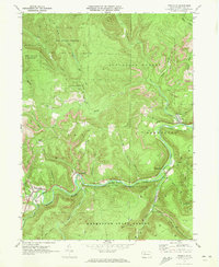 1970 Weedville1973 Print · USGSElk County at the start of the 1970s reveals a rugged coal and gas landscape along the Bennett Branch Sinnemahoning Creek. Trace the path of the Penn Central rail line through Weedville and Benezette, or locate family sites at Mt Zion Ch and Gray Cem.3 unique versions available
 - 1971 Map of Warren
 1971 Warren1971 Print · USGSNorth Central Pennsylvania is captured here in the early seventies, showing a landscape defined by industrial centers and massive state forests. Genealogists and historians can trace the rail lines of the Penn Central and Erie Lackawanna connecting towns like Warren, Kane, and Du Bois.
End of results
Showing maps 1-5 of 5
Top cities of Elk County
- Saint Marys historical maps
- Ridgway historical maps
- Johnsonburg historical maps
- Benezette Township historical maps
- Millstone Township historical maps
Frequently asked questions
- What are the different types of historical maps available for Elk County?
- What is the oldest map of Elk County?
- Where can I purchase historical maps of Elk County for my home or office?
- Where can I download high-res historical maps of Elk County?
- Are there historical topographic maps available for Elk County?
- Is there historical aerial imagery available for Elk County?
- Where are historical maps of Elk County sourced from?