1940s Maps of Elk County, Pennsylvania
Explore 14 historic maps of Elk County from the 1940s. These maps offer a rare glimpse into what life looked like during the 1940s — showing old roads, neighborhoods, homes, and landmarks that have changed or disappeared over time.
Whether you're researching your family's past, planning a metal detecting trip, or studying how Elk County's landscape evolved across the 1940s, these high-resolution maps are a powerful tool for exploring the history of this region.
- Focus on a specific era: All maps on this page are from the 1940s, giving you a focused view of this time period.
- See what’s changed: Compare century-old streets, trails, and buildings to today's modern landscape using overlays and satellite layers.
- Research with precision: Use these maps for genealogy, historical research, land use analysis, or educational projects.
- View, download, or print: Maps are fully viewable online in high resolution, and can be downloaded or printed for your own records.
Start exploring Elk County's history through authentic maps from the 1940s. This is your window into the past.
Elk County, PA maps
(14)- 1940 Map of Hallton
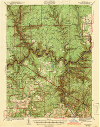
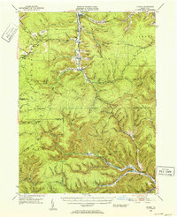
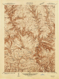 1940 Hallton1940 Print · USGSElk and Jefferson Counties appear here in the early 1940s, showing a landscape defined by the Clarion River valley and the growth of the Allegheny National Forest. Researchers can find old industrial sites and rural landmarks like the Empire Tunnel, St Tobias Cem, and the CCC Camp.3 unique versions available
 - 1940 Map of Mt. Jewett
 1940 Mt. Jewett1940 Print · USGSNorthern Pennsylvania’s timber and rail country is captured here during the mid-1930s, showing a landscape defined by industrial development. Researchers can locate vanished rural infrastructure like the Stenstrom Sch, the CCC Camp, and specific rail stops at Dahoga and Instanter.3 unique versions available
 - 1941 Map of Marienville
 1941 Marienville1941 Print · USGSForest, Clarion, and Jefferson counties meet along the winding Clarion River in this pre-war survey of northern Pennsylvania's timberlands. Genealogists can locate numerous rural schoolhouses and social landmarks like Kahletown Hall, Greenwood Ch, and the Downey Cem.3 unique versions available
 - 1941 Map of Benezette, 1952 Print
 1941 Benezette1952 Print · USGSElk County at the start of the 1940s reveals a network of valley settlements defined by the Pennsylvania RR and Sinnemahoning Creek. Researchers can trace rural life through scattered landmarks like Mt Zion Ch, Rathbun Sch, and the high point at Winslow Hill.3 unique versions available
 - 1941 Map of Ridgway, 1956 Print
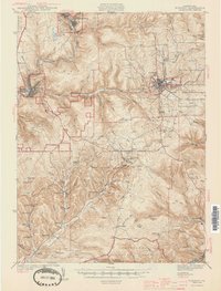
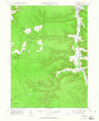
 1941 Ridgway1956 Print · USGSElk County at the start of the 1940s reveals a landscape shaped by coal mining and heavy rail industry. Genealogists can locate family homes near Dagus Mines or trace the early foundations of Ridgway and St. Marys.2 unique versions available
 - 1943 Map of Hallton
 1943 Hallton1943 Print · USGSThe Clarion River valley and surrounding plateau are captured here just before the mid-century, revealing a network of isolated settlements and forest industry. Researchers can find old sites like the CCC Camp near Croyland, the Empire Tunnel, and small rural schools including Lake City Sch.3 unique versions available
 - 1943 Map of Benezette
 1943 Benezette1943 Print · USGSElk and Cameron counties are captured during the early 1940s, showing a landscape of deep timber-run hollows and active rail corridors. Local historians can locate vanished schoolhouses like Rathbun Sch, mountain churches such as Mt Zion Ch, and the winding tracks of the Pennsylvania railroad.2 unique versions available
 - 1944 Map of Ridgway
 1944 Ridgway1944 Print · USGSElk County at the height of its industrial rail era reveals a landscape of coal mines and mountain settlements. Trace the operations of the Toby Mine and Kyler Mine or find family roots at Decker Chapel and Gardner Hill Sch.3 unique versions available
 - 1945 Map of Driftwood, 1953 Print
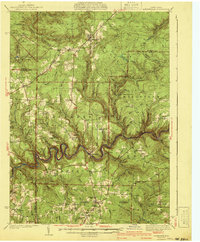
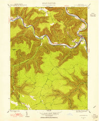
 1945 Driftwood1953 Print · USGSCameron County communities thrive along the river bends and rail lines at the end of World War II. Researchers can trace the dual rail paths of the Pennsylvania and Baltimore and Ohio railroads through Driftwood and locate the First Fork Sch.4 unique versions available
 - 1945 Map of Driftwood, 1955 Print
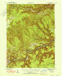
 1945 Driftwood1955 Print · USGSCameron and Elk Counties reveal their mid-century industrial character along the river valleys of the Allegheny Plateau. Researchers can trace the dual influence of the Baltimore and Ohio railroad and isolated mountain burial grounds like Mason Hill Cem and Mix Run Cem.3 unique versions available
 - 1947 Map of Driftwood
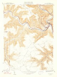 1947 Driftwood1947 Print · USGSCameron County's rugged rail corridors and remote river valleys are captured here just after the war. Researchers can trace historic family burial sites at Mason Hill Cem and Mix Run Cem or locate the old junctions at Driftwood and Castle Garden.2 unique versions available
 - 1948 Map of Crosby, 1952 Print
 1948 Crosby1952 Print · USGSPost-war McKean and Cameron counties appear here as a landscape of mountain rail lines and valley settlements. Trace the Pennsylvania Railroad through Hamlin Sta, locate the Sweets Sch, or find family names near Clermont Cem.3 unique versions available
 - 1948 Map of Wildwood Fire Tower, 1958 Print
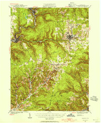
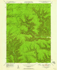 1948 Wildwood Fire Tower1958 Print · USGSThe Pennsylvania high country of Elk and McKean counties comes into focus in the years just after the war, showing a landscape of deep hollows and forest runs. Genealogists and hikers can trace the remote reaches of Wellendorf Station, Devils Hole, and Boy Scout Hollow.5 unique versions available
 - 1948 Map of Crosby, 1965 Print
 1948 Crosby1965 Print · USGSMcKean County at the end of the 1940s reveals a rugged landscape of narrow valley settlements and high-altitude pipe lines. Local historians can trace the rail sidings at Hamlin Sta and search for family roots at Norwich Cem or the isolated village of Betula.3 unique versions available
End of results
Showing maps 1-14 of 14
Top cities of Elk County
- Saint Marys historical maps
- Ridgway historical maps
- Johnsonburg historical maps
- Benezette Township historical maps
- Millstone Township historical maps
Frequently asked questions
- What are the different types of historical maps available for Elk County?
- What is the oldest map of Elk County?
- Where can I purchase historical maps of Elk County for my home or office?
- Where can I download high-res historical maps of Elk County?
- Are there historical topographic maps available for Elk County?
- Is there historical aerial imagery available for Elk County?
- Where are historical maps of Elk County sourced from?