1950s Maps of Elk County, Pennsylvania
Explore 10 historic maps of Elk County from the 1950s. These maps offer a rare glimpse into what life looked like during the 1950s — showing old roads, neighborhoods, homes, and landmarks that have changed or disappeared over time.
Whether you're researching your family's past, planning a metal detecting trip, or studying how Elk County's landscape evolved across the 1950s, these high-resolution maps are a powerful tool for exploring the history of this region.
- Focus on a specific era: All maps on this page are from the 1950s, giving you a focused view of this time period.
- See what’s changed: Compare century-old streets, trails, and buildings to today's modern landscape using overlays and satellite layers.
- Research with precision: Use these maps for genealogy, historical research, land use analysis, or educational projects.
- View, download, or print: Maps are fully viewable online in high resolution, and can be downloaded or printed for your own records.
Start exploring Elk County's history through authentic maps from the 1950s. This is your window into the past.
Elk County, PA maps
(10)- 1950 Map of Wildwood Fire Tower
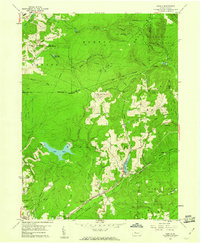
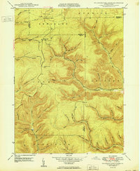 1950 Wildwood Fire Tower1950 Print · USGSThe Elk and McKean county line runs through this mid-century survey of the Pennsylvania highlands, featuring rugged drainage networks and early timbering hubs. Genealogists can trace family-named hollows and sites like Wellendorf Station, Dead Mans Lick, and Wildwood Fire Tower.2 unique versions available
 - 1950 Map of Crosby
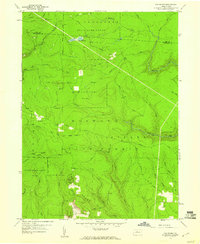
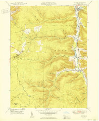 1950 Crosby1950 Print · USGSThe Potato Creek valley in McKean County is captured here at mid-century, following the river-and-rail corridor. Genealogists can trace family names and sites at Clermont, Hamlin Sta, and Norwich Cem, or follow the Pennsylvania railroad line.
 - 1957 Map of Warren, 1964 Print
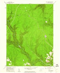
 1957 Warren1964 Print · USGSThe northern Pennsylvania oil and timber country comes into focus in the mid-fifties, showing the region before modern highway expansions. Trace the industrial rail networks of the Pennsylvania RR and the early Allegheny River Reservoir near Warren and Oil City.4 unique versions available
 - 1958 Map of Warren
 1958 Warren1958 Print · USGSNorthern Pennsylvania’s timber and oil country is captured here during the late fifties, showing the interplay of industrial valleys and vast state forests. Genealogists can trace family connections across the Cornplanter Indian Reservation or through rail hubs like Oil City and Saint Marys.
 - 1959 Map of Warren
 1959 Warren1959 Print · USGSNorthern Pennsylvania's oil and timber country comes alive in this late-fifties study of the forest-clad plateaus. Trace the historic Cornplanter (Indian Reservation), the sprawling Oil Field, and the rail lines of the Pennsylvania RR.2 unique versions available
 - 1959 Map of Huntley, 1960 Print
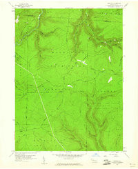 1959 Huntley1960 Print · USGSThe high woods of Clearfield and Elk counties are captured here at the end of the 1950s, showing a land balanced between resource extraction and recreation. Researchers can trace early energy development at various Gas Well sites or locate landmarks like Panther Rocks and Parker Dam State Park.3 unique versions available
 - 1959 Map of Penfield, 1960 Print
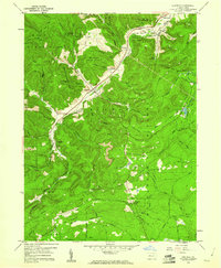 1959 Penfield1960 Print · USGSClearfield County is shown at a mid-century peak of resource extraction and forestry during the late 1950s. Genealogists and historians can trace rail-side settlements like Penfield and Winterburn, or locate family sites near the Mt Pleasant Cem and Laurel Run Cem.5 unique versions available
 - 1959 Map of Sabula, 1960 Print
 1959 Sabula1960 Print · USGSThe highland railroads and coal-mining operations of Clearfield and Jefferson counties are documented here in the late fifties. Researchers can trace historic family burial sites at Bundy Cem and Morningside Cemetery or locate the Sabula Tunnel and Boy Scout Camp.7 unique versions available
 - 1959 Map of The Knobs, 1960 Print
 1959 The Knobs1960 Print · USGSThe wooded highlands of Clearfield County are captured here in the late fifties, a time when fire towers and logging roads defined the backcountry. Researchers can trace historical routes like the Caledonia Pike and locate landmarks such as the Knobs Lookout Tower and Old Round Top.6 unique versions available
 - 1959 Map of Devils Elbow, 1960 Print
 1959 Devils Elbow1960 Print · USGSThe high plateau of Clearfield and Cameron Counties is shown here in the late fifties, dominated by the timberlands of the Moshannon State Forest. Genealogists and outdoorsmen can trace the rugged topography near Quehanna, locating isolated landmarks like the Lookout Tower and Arnold Mtn.4 unique versions available
End of results
Showing maps 1-10 of 10
Top cities of Elk County
- Saint Marys historical maps
- Ridgway historical maps
- Johnsonburg historical maps
- Benezette Township historical maps
- Millstone Township historical maps
Frequently asked questions
- What are the different types of historical maps available for Elk County?
- What is the oldest map of Elk County?
- Where can I purchase historical maps of Elk County for my home or office?
- Where can I download high-res historical maps of Elk County?
- Are there historical topographic maps available for Elk County?
- Is there historical aerial imagery available for Elk County?
- Where are historical maps of Elk County sourced from?