1960s Maps of Spring Creek Township, Pennsylvania
Explore 3 historic maps of Spring Creek Township from the 1960s. These maps offer a rare glimpse into what life looked like during the 1960s — showing old roads, neighborhoods, homes, and landmarks that have changed or disappeared over time.
Whether you're researching your family's past, planning a metal detecting trip, or studying how Spring Creek Township's landscape evolved across the 1960s, these high-resolution maps are a powerful tool for exploring the history of this region.
- Focus on a specific era: All maps on this page are from the 1960s, giving you a focused view of this time period.
- See what’s changed: Compare century-old streets, trails, and buildings to today's modern landscape using overlays and satellite layers.
- Research with precision: Use these maps for genealogy, historical research, land use analysis, or educational projects.
- View, download, or print: Maps are fully viewable online in high resolution, and can be downloaded or printed for your own records.
Start exploring Spring Creek Township's history through authentic maps from the 1960s. This is your window into the past.
Spring Creek Township, PA maps
(3)- 1969 Map of Munderf, 1972 Print
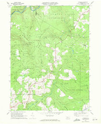 1969 Munderf1972 Print · USGSJefferson County was a landscape of dense timber and energy extraction in the late sixties, where state forests met active gas fields. Genealogists and researchers can trace local families through small settlements like Munderf, the remote Munderf Cem, and old crossroads at Schoffner Corner and Dutch Hill.3 unique versions available
 - 1969 Map of Hallton, 1972 Print
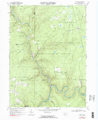 1969 Hallton1972 Print · USGSElk County's deep woods and river valleys are captured here in the late sixties as the regional gas industry and national forest lands shaped the terrain. Researchers can locate the Maxwell Run Cem, the river settlement of Arroyo, and the remote Lookout Tower.2 unique versions available
 - 1969 Map of Portland Mills, 1972 Print
 1969 Portland Mills1972 Print · USGSElk County during the late sixties shows a landscape of deep woods and industrial utility. Genealogists and historians can trace the Penn Central rail lines, find family names at Ott Cem, or locate landmarks like Kings Airfield and Portland Mills.2 unique versions available
End of results
Showing maps 1-3 of 3
Top cities near Spring Creek Township
- Sandy Township historical maps
- Ridgway historical maps
- Brookville historical maps
- Johnsonburg historical maps
- Brockway historical maps
- Warsaw Township historical maps
See more
Top neighborhoods of Spring Creek Township
- Arroyo historical maps
- Beuhler Corner historical maps
- Hallton historical maps
- Croyland historical maps
- Portland Mills historical maps
- Lake City historical maps
See more
Frequently asked questions
- What are the different types of historical maps available for Spring Creek Township?
- What is the oldest map of Spring Creek Township?
- Where can I purchase historical maps of Spring Creek Township for my home or office?
- Where can I download high-res historical maps of Spring Creek Township?
- Are there historical topographic maps available for Spring Creek Township?
- Is there historical aerial imagery available for Spring Creek Township?
- Where are historical maps of Spring Creek Township sourced from?