1930s Maps of Kingsley Township, Pennsylvania
Explore 3 historic maps of Kingsley Township from the 1930s. These maps offer a rare glimpse into what life looked like during the 1930s — showing old roads, neighborhoods, homes, and landmarks that have changed or disappeared over time.
Whether you're researching your family's past, planning a metal detecting trip, or studying how Kingsley Township's landscape evolved across the 1930s, these high-resolution maps are a powerful tool for exploring the history of this region.
- Focus on a specific era: All maps on this page are from the 1930s, giving you a focused view of this time period.
- See what’s changed: Compare century-old streets, trails, and buildings to today's modern landscape using overlays and satellite layers.
- Research with precision: Use these maps for genealogy, historical research, land use analysis, or educational projects.
- View, download, or print: Maps are fully viewable online in high resolution, and can be downloaded or printed for your own records.
Start exploring Kingsley Township's history through authentic maps from the 1930s. This is your window into the past.
Kingsley Township, PA maps
(3)- 1930 Map of Tidioute
 1930 Tidioute1930 Print · USGSThe Allegheny River valley and the Pennsylvania Railroad corridor are shown in detail during the late 1920s. Genealogists and historians can trace defunct school sites like Triumph Sch and remote settlements such as Fagundus or Trunkeyville.4 unique versions available
 - 1935 Map of Sheffield
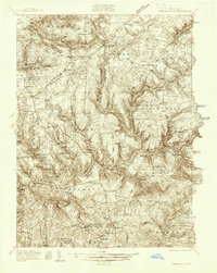
 1935 Sheffield1935 Print · USGSThe Allegheny National Forest region in the mid-1930s reveals a landscape of deep timber runs, winding rail lines, and isolated New Deal work camps. Researchers can trace family roots at Cherry Grove Cem or locate forgotten crossroads like Deadmans Corners and Seldom Seen Corners.2 unique versions available
 - 1936 Map of Marienville
 1936 Marienville1936 Print · USGSThe Pennsylvania highlands between the Clarion River and Allegheny National Forest appear here in the mid-1930s. Researchers can trace the Baltimore and Ohio RR through Marienville or locate family landmarks like Donnely Cem and Greenwood Ch.3 unique versions available
End of results
Showing maps 1-3 of 3
Top cities near Kingsley Township
- Sheffield Township historical maps
- Tidioute historical maps
- Tionesta historical maps
- President Township historical maps
- Triumph Township historical maps
- Cherry Grove Township historical maps
See more
Top neighborhoods of Kingsley Township
- Mayburg historical maps
- Whig Hill historical maps
- Crystal Springs historical maps
- Kellettville historical maps
- Starr historical maps
- Muzette historical maps
Frequently asked questions
- What are the different types of historical maps available for Kingsley Township?
- What is the oldest map of Kingsley Township?
- Where can I purchase historical maps of Kingsley Township for my home or office?
- Where can I download high-res historical maps of Kingsley Township?
- Are there historical topographic maps available for Kingsley Township?
- Is there historical aerial imagery available for Kingsley Township?
- Where are historical maps of Kingsley Township sourced from?