1990s Maps of Licking Creek Township, Pennsylvania
Explore 3 historic maps of Licking Creek Township from the 1990s. These maps offer a rare glimpse into what life looked like during the 1990s — showing old roads, neighborhoods, homes, and landmarks that have changed or disappeared over time.
Whether you're researching your family's past, planning a metal detecting trip, or studying how Licking Creek Township's landscape evolved across the 1990s, these high-resolution maps are a powerful tool for exploring the history of this region.
- Focus on a specific era: All maps on this page are from the 1990s, giving you a focused view of this time period.
- See what’s changed: Compare century-old streets, trails, and buildings to today's modern landscape using overlays and satellite layers.
- Research with precision: Use these maps for genealogy, historical research, land use analysis, or educational projects.
- View, download, or print: Maps are fully viewable online in high resolution, and can be downloaded or printed for your own records.
Start exploring Licking Creek Township's history through authentic maps from the 1990s. This is your window into the past.
Licking Creek Township, PA maps
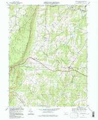
(3)- 1990 Map of Mc Connellsburg, 1995 Print
 1990 Mc Connellsburg1995 Print · USGSFranklin and Fulton Counties in the 1990s showcase a landscape of protected state forests and historic ridge-and-valley settlements. Researchers can trace the path of the Old Railroad Grade or locate local landmarks like Richmond Furnace and the Mountain View Sch.
 - 1994 Map of Hustontown, 1997 Print
 1994 Hustontown1997 Print · USGSCentral Pennsylvania's ridge-and-valley country is captured here in the mid-1990s, centered on the intersection of the turnpike and local rural life. Genealogists can locate family landmarks like Mellotts Mill, Dublin Mills, and several country churches including Fairview Ch.
 - 1994 Map of Meadow Grounds, 1997 Print
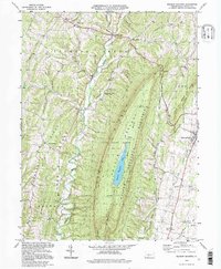 1994 Meadow Grounds1997 Print · USGSFulton County settlements and rugged ridge-and-valley terrain are captured here in the mid-1990s as the landscape balances conservation and community. Researchers can locate family landmarks like Wink Cem, Bethlehem Ch, and the valley village of Harrisonville.
End of results
Showing maps 1-3 of 3
Top cities near Licking Creek Township
- Metal Township historical maps
- Mercersburg historical maps
- McConnellsburg historical maps
- Todd Township historical maps
- Three Springs historical maps
- Broad Top City historical maps
See more
Top neighborhoods of Licking Creek Township
- Mellotts Mill historical maps
- Saluvia historical maps
- Andover historical maps
- Breezy Point historical maps
- Green Hill historical maps
- Harrisonville historical maps
See more
Frequently asked questions
- What are the different types of historical maps available for Licking Creek Township?
- What is the oldest map of Licking Creek Township?
- Where can I purchase historical maps of Licking Creek Township for my home or office?
- Where can I download high-res historical maps of Licking Creek Township?
- Are there historical topographic maps available for Licking Creek Township?
- Is there historical aerial imagery available for Licking Creek Township?
- Where are historical maps of Licking Creek Township sourced from?