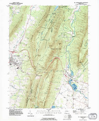
1990 Map of Mc Connellsburg
USGS Topo · Published 1995About this map
Tuscarora Mountain and Cove Mountain dominate this landscape in South Central Pennsylvania, carving out a series of narrow valleys where local industry and transportation networks took root by the late 20th century. The village of Richmond Furnace and the community of Fort Loudon highlight the region's historical industrial ties, while the Old Railroad Grade and Old RR Grade trace the legacy of mountain-spanning transport.
Find a feature on this map
85 named features on this map. Tap any name to fly to it.
Don’t see what you’re looking for? This feature index may not catch every label — zoom into the map to look around manually.
Map Details
Editions of this 1990 Mc Connellsburg Map
This is the sole edition of this map. No revisions or reprints were ever made.
Other maps of this area

1900 · Mercersburg
USGS Topo · 1:62,500

1902 · Mercersburg
USGS Topo · 1:62,500

1925 · Needmore
USGS Topo · 1:48,000

1930 · Broad Top
USGS Topo · 1:62,500

1933 · Broad Top
USGS Topo · 1:62,500

1935 · Needmore
USGS Topo · 1:62,500

1939 · Needmore
USGS Topo · 1:62,500

1939 · Orbisonia
USGS Topo · 1:62,500

1940 · Orbisonia
USGS Topo · 1:62,500

1942 · Hagerstown
USGS Topo · 1:125,000