Old Maps of Salisbury Township, Pennsylvania for Academic Research
Study the evolution of Salisbury Township with 64 high-resolution historic maps. Whether you're teaching, researching, or modeling changes in land use, these maps provide essential visual documentation of urban, environmental, and geographic change.
- Analyze long-term change: Track patterns in development, transportation, and natural features.
- Ideal for environmental or urban studies: Support academic projects with primary historical map data.
- Use in the classroom or lab: Educators and researchers rely on these maps to bring historical context to life.
These maps are a powerful tool for teaching, research, and visualizing how Salisbury Township has changed over the decades.
Salisbury Township, PA maps
(64)- 1904 Map of Coatesville, 1960 Print
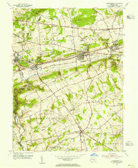
 1904 Coatesville1960 Print · USGSChester County at the turn of the century shows a bustling corridor of industry and education nestled between the Valley Hills and Mine Ridge. Trace the early development of Lincoln University, the rail hubs at Coatesville, and rural landmarks like Faggs Manor Ch.
 - 1905 Map of Honey Brook, 1962 Print
 1905 Honey Brook1962 Print · USGSSoutheastern Pennsylvania at the start of the twentieth century shows a landscape shaped by iron furnaces and a dense rail network. Genealogists can trace family footprints at Joanna Furnace, Hummels Store, and numerous rural sites like Silver Hill School.
 - 1906 Map of Coatesville
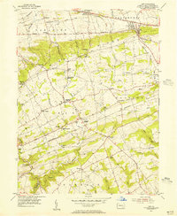
 1906 Coatesville1906 Print · USGSChester County during the first decade of the 1900s reveals a landscape defined by industrial expansion and established rural hamlets. Researchers can trace the early footprint of Lincoln University and follow historic turnpikes through settlements like Faggs Manor, Parkesburg, and Ercildoun.8 unique versions available
 - 1906 Map of New Holland, 1962 Print
 1906 New Holland1962 Print · USGSLancaster County at the start of the twentieth century shows a landscape transitioning from turnpikes to electric railways. Genealogists can trace family roots through an extensive network of rural landmarks, including Heller Church, Red Well School, and the early Waterworks at Ephrata.
 - 1907 Map of Honeybrook
 1907 Honeybrook1907 Print · USGSSoutheast Pennsylvania at the start of the twentieth century shows a landscape defined by small hamlets and early rail lines. Genealogists can trace family names and local hubs from Honeybrook and Churchtown to rural landmarks like Spoketown School and Harmony Church.7 unique versions available
 - 1908 Map of New Holland
 1908 New Holland1908 Print · USGSLancaster County at the turn of the century shows a thriving landscape of rural schoolhouses and turnpike villages. Genealogists can locate family landmarks like Middle Creek Church, Heller Church, and dozens of local schools from Stony Hill School to Clay School.6 unique versions available
 - 1912 Map of Quarryville
 1912 Quarryville1912 Print · USGSLancaster County's agrarian and industrial character is frozen in time here, shortly after the 1910 survey. Researchers can trace the heavy influence of the rail network through Nickel Mines or locate rural landmarks like Wheatland Mills and Mechanic Grove.6 unique versions available
 - 1918 Map of Coatesville, 1921 Print
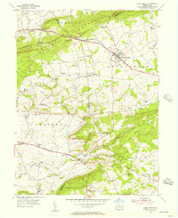
 1918 Coatesville1921 Print · USGSChester County and the Lancaster border are captured in the late First World War era as industrial and academic centers thrived. Trace the early layout of Lincoln University, the busy Pennsylvania R.R. corridor, and old post offices like Springdell Derbydown PO.
 - 1941 Map of Honeybrook
 1941 Honeybrook1941 Print · USGSSoutheastern Pennsylvania at the onset of the Second World War shows a landscape of established farm communities and the newly cut path of the Pennsylvania Turnpike. Researchers can locate numerous local landmarks such as Silver Hill School, Stone Church, and the rail stops along the Reading Lines.
 - 1941 Map of New Holland
 1941 New Holland1941 Print · USGSLancaster County’s agricultural heartland is documented here just as the modern highway era arrived. Genealogists and local historians can trace family locations through dozens of named rural landmarks like Heller Church, Fetter School, and the Pennsylvania RR corridor.
 - 1943 Map of Coatesville
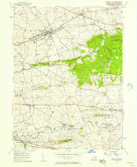
 1943 Coatesville1943 Print · USGSChester County's industrial and rural landscape is shown in detail during the early 1940s, centered on the rail-driven growth of the Octoraro and Brandywine valleys. Family historians can trace ancestral roots through small hamlets and transit points like Derbydown PO, Doe Run Sta, and Sadsburyville.
 - 1943 Map of Quarryville
 1943 Quarryville1943 Print · USGSSouthern Lancaster County is captured in detail during the early forties, showcasing a landscape of tight-knit rural townships and rail-connected villages. Genealogists can trace family footprints across numerous local sites like Nickel Mines, Conners Mill, and North Star School.
 - 1944 Map of Newark, 1971 Print
 1944 Newark1971 Print · USGSThe industrial corridor from Philadelphia to New York was in a period of massive transition during the mid-forties. Genealogists and researchers can trace the rail lines of the Lehigh Valley RR, locate military installations like Picatinny Arsenal, and explore the early sprawl near Levittown.5 unique versions available
 - 1946 Map of Wilmington, 1948 Print
 1946 Wilmington1948 Print · USGSThe Delaware Valley and Jersey Shore emerge in this mid-century portrait of a region defined by river commerce and seaside growth. Genealogists and historians can trace the rail networks of the Pennsylvania Railroad, locate early airfields like Dover Airpark, and find river defenses at Fort Delaware.2 unique versions available
 - 1948 Map of Baltimore
 1948 Baltimore1948 Print · USGSMaryland and Pennsylvania crossroads are captured in the late 1940s, showing a landscape defined by historic rail lines and major military installations. Genealogists can trace family connections in Gettysburg, Westminster, and near the U.S. Naval Academy in Annapolis.2 unique versions available
 - 1949 Map of Newark
 1949 Newark1949 Print · USGSThe industrial corridor between Philadelphia and New York comes alive in this post-war survey. Genealogists and historians can trace the massive rail networks of the Reading Railroad and locate major installations like Fort Dix or Picatinny Arsenal.2 unique versions available
 - 1950 Map of Harrisburg, 1952 Print
 1950 Harrisburg1952 Print · USGSMid-century Central Pennsylvania comes alive through its dense rail networks and river valley settlements during the post-war industrial era. Genealogists and historians can trace family roots through hubs like Harrisburg, locate Carlisle Barracks, or follow the Pennsylvania RR through the Lebanon Valley.
 - 1953 Map of Parkesburg, 1955 Print
 1953 Parkesburg1955 Print · USGSChester County's rail-and-valley landscape is captured here in the early fifties, showing the busy industrial corridor of the Pennsylvania Railroad. Trace old family sites near Sadsbury Meeting House or the rural crossroads of Cochranville.5 unique versions available
 - 1954 Map of Baltimore
 1954 Baltimore1954 Print · USGSThe Mid-Atlantic region in the early fifties shows a landscape of growing suburban centers and heavy rail corridors. Trace mid-century transit networks and military landmarks from the Aberdeen Proving Ground to the Gettysburg National Military Park.
 - 1955 Map of Wilmington
 1955 Wilmington1955 Print · USGSThe Delaware Valley and Jersey Shore are seen here during the mid-fifties era of rapid suburban expansion and highway development. You can trace the path of the New Jersey Turnpike, locate the Fort Dix Military Reservation, or explore the rail networks of the Pennsylvania Railroad.
 - 1955 Map of Gap, 1956 Print
 1955 Gap1956 Print · USGSEastern Lancaster County in the mid-fifties shows a landscape of ridge-top mines and valley farms centered on the strategic Gap pass. Genealogists can locate family homes and landmarks like Nickel Mines, Georgetown (Bart PO), and the Octoraro Ch.6 unique versions available
 - 1955 Map of Honey Brook, 1957 Print
 1955 Honey Brook1957 Print · USGSChester and Lancaster counties are captured here in the mid-fifties, showing a landscape shaped by historic turnpikes and the wooded heights of Welsh Mountain. Researchers can trace old family-named landmarks and institutions like St Johns Church, Bridgeville Ch, and the Kings Highway Sch.6 unique versions available
 - 1956 Map of Baltimore
 1956 Baltimore1956 Print · USGSMid-century Maryland and Pennsylvania are captured here during a period of massive suburban and military growth across the Chesapeake region. Genealogists and historians can trace the rail corridors of the Baltimore & Ohio RR and locate landmarks like Fort McHenry or the Aberdeen Proving Ground.
 - 1956 Map of Newark
 1956 Newark1956 Print · USGSThe industrial heart of the Mid-Atlantic is captured here at the dawn of the highway era, tracing the dense corridors between Newark and Philadelphia. Genealogists and local historians can map the rail networks of the Reading RR or locate mid-century military life at Fort Dix Military Reservation.2 unique versions available
 - 1956 Map of New Holland, 1957 Print
 1956 New Holland1957 Print · USGSLancaster County in the mid-fifties shows a landscape of deep-rooted settlements and thriving rural schools. Genealogists can trace family landmarks and community hubs like Intercourse, the Pequea Valley High Sch, and Lady of Lourdes Ch.5 unique versions available
Showing maps 1-25 of 64
Top cities near Salisbury Township
- West Lampeter Township historical maps
- Coatesville historical maps
- Ephrata historical maps
- Caln Township historical maps
- New Garden Township historical maps
- East Earl Township historical maps
See more
Top neighborhoods of Salisbury Township
- Salisbury Heights historical maps
- White Horse historical maps
- Buena Vista historical maps
- Cambridge historical maps
- Limeville historical maps
- Meadville historical maps
See more
Frequently asked questions
- What are the different types of historical maps available for Salisbury Township?
- What is the oldest map of Salisbury Township?
- Where can I purchase historical maps of Salisbury Township for my home or office?
- Where can I download high-res historical maps of Salisbury Township?
- Are there historical topographic maps available for Salisbury Township?
- Is there historical aerial imagery available for Salisbury Township?
- Where are historical maps of Salisbury Township sourced from?