1950s Maps of Luzerne County, Pennsylvania
Explore 26 historic maps of Luzerne County from the 1950s. These maps offer a rare glimpse into what life looked like during the 1950s — showing old roads, neighborhoods, homes, and landmarks that have changed or disappeared over time.
Whether you're researching your family's past, planning a metal detecting trip, or studying how Luzerne County's landscape evolved across the 1950s, these high-resolution maps are a powerful tool for exploring the history of this region.
- Focus on a specific era: All maps on this page are from the 1950s, giving you a focused view of this time period.
- See what’s changed: Compare century-old streets, trails, and buildings to today's modern landscape using overlays and satellite layers.
- Research with precision: Use these maps for genealogy, historical research, land use analysis, or educational projects.
- View, download, or print: Maps are fully viewable online in high resolution, and can be downloaded or printed for your own records.
Start exploring Luzerne County's history through authentic maps from the 1950s. This is your window into the past.
Luzerne County, PA maps
(26)- 1950 Map of Wilkes-Barre West
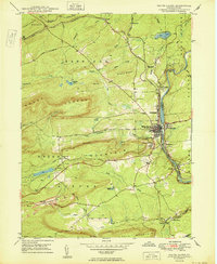
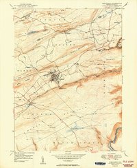
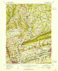
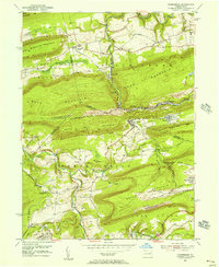
 1950 Wilkes-Barre West1950 Print · USGSThe Susquehanna Valley thrives in this mid-century portrait of Pennsylvania's coal country. Genealogists and historians can trace the footprint of Wilkes-Barre alongside local landmarks like Shawnee Cem and the Pennsylvania RR.2 unique versions available
 - 1950 Map of Wilkes-Barre East
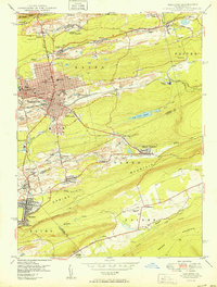
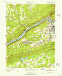
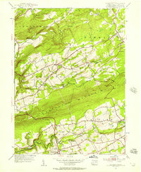
 1950 Wilkes-Barre East1950 Print · USGSLuzerne County at the midpoint of the century shows a landscape defined by coal extraction, mountain railroading, and upland resorts. Genealogists and researchers can trace family landmarks like Oliver Mills, Llewellyn Corners, and the historic Holy Trinity Cem.2 unique versions available
 - 1950 Map of White Haven
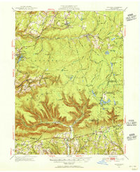
 1950 White Haven1950 Print · USGSThe industrial Lehigh River corridor is captured here just after the war, showing the vital rail and mining networks of the day. Researchers can trace family sites at White Haven or Pond Creek, and locate features like the Ripple Sch and Jefferson Hospital.2 unique versions available
 - 1950 Map of Hazleton
 1950 Hazleton1950 Print · USGSThe anthracite coal region of Pennsylvania comes into sharp focus during the post-war era. Researchers can trace the extensive rail networks of the Lehigh Valley and identify localized mining communities like Lattimer Mines (PO) and Coxes Village.2 unique versions available
 - 1950 Map of Nuremberg
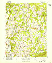
 1950 Nuremberg1950 Print · USGSThe tri-county borderlands of Eastern Pennsylvania are captured here at the start of the 1950s. Genealogists can trace family names at Millers Corner and Raricks, or locate ancestors at the Nuremberg Cem and Mt Zion Ch.2 unique versions available
 - 1950 Map of Freeland
 1950 Freeland1950 Print · USGSLuzerne County's anthracite country is documented here in the mid-century, showing the intensive mining operations and rail networks around the borough of Freeland. Researchers can trace the industrial landscape of Upper Lehigh or locate local landmarks like Honey Hole, Kis-Lyn, and St Ann Cem.2 unique versions available
 - 1950 Map of Weatherly
 1950 Weatherly1950 Print · USGSWeatherly and the surrounding anthracite coal fields are documented here in the late 1940s as industry and local life intertwined. Genealogists and historians can trace family locations near St Joseph Ch, the Larrytown Sch, and the old company town at Eckley.2 unique versions available
 - 1950 Map of Harrisburg, 1952 Print
 1950 Harrisburg1952 Print · USGSMid-century Central Pennsylvania comes alive through its dense rail networks and river valley settlements during the post-war industrial era. Genealogists and historians can trace family roots through hubs like Harrisburg, locate Carlisle Barracks, or follow the Pennsylvania RR through the Lebanon Valley.
 - 1950 Map of Scranton, 1952 Print
 1950 Scranton1952 Print · USGSMid-century Northeast Pennsylvania and the Hudson Valley come alive in this survey of the tri-state region. Genealogists and historians can trace the dense rail networks of the Erie RR and DL&W RR between industrial hubs like Scranton and Wilkes-Barre.
 - 1953 Map of Scranton
 1953 Scranton1953 Print · USGSNortheastern Pennsylvania and the Catskills are shown in great detail during the early fifties, a time when rail lines and river valleys dictated the region's growth. Genealogists and historians can trace the industrial hearts of Scranton and Wilkes-Barre or locate remote landmarks like High Point and Lake Wallenpaupack.
 - 1953 Map of LaPorte, 1956 Print
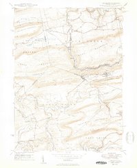
 1953 LaPorte1956 Print · USGSSullivan County's plateau country is captured here during the early 1950s, showing a landscape of small coal towns and growing state parks. Researchers can find many rural landmarks, including Painter Mills, Sugarloaf Sch, and the high waters of Ganoga Lake.3 unique versions available
 - 1954 Map of Williamsport
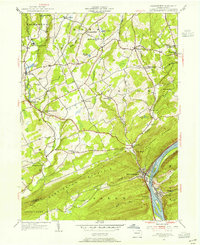
 1954 Williamsport1954 Print · USGSNorth-central Pennsylvania in the mid-fifties is defined by the winding West Branch Susquehanna River and its industrial valley. Local historians can trace the massive Susquehanna Ordnance Depot and the extensive rail networks of the Pennsylvania Railroad.
 - 1954 Map of Stillwater, 1955 Print
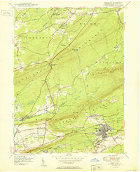
 1954 Stillwater1955 Print · USGSNortheastern Pennsylvania’s agricultural and woodland landscape is captured here in the mid-fifties, centered on the boundary of Columbia and Luzerne counties. Genealogists can trace family roots through landmarks like Thompson Cem, Zaner Sch, and the Reading rail corridor.4 unique versions available
 - 1954 Map of Shickshinny, 1955 Print
 1954 Shickshinny1955 Print · USGSLuzerne County's river-and-mountain landscape is captured here in the mid-1950s, centered on the borough of Shickshinny and its crossing to Mocanaqua. Researchers can trace rural life through landmarks like Patterson Grove, the Lower Muhlenburg Ch, and the Pennsylvania rail line.5 unique versions available
 - 1954 Map of Bloomsburg, 1955 Print
 1954 Bloomsburg1955 Print · USGSBloomsburg and the Susquehanna River valley are captured in the mid-fifties, showing the region's transition from riverfront industry to upland farming. Genealogists can trace family names across Coles Mill, Hidlay Ch Cem, and the State Teachers College.2 unique versions available
 - 1954 Map of Nanticoke, 1956 Print
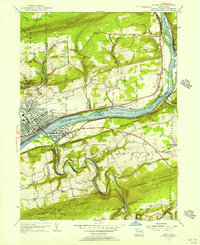
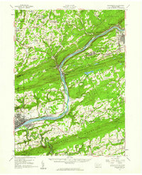
 1954 Nanticoke1956 Print · USGSLuzerne County's industrial heartland is captured here in the mid-fifties, showing the rail-heavy corridor of the Susquehanna River. Genealogists can trace family footprints at St Marys Cem, Hunlock Creek, and the many coal-patch churches like Mt Zion Union Ch.5 unique versions available
 - 1955 Map of Berwick, 1956 Print
 1955 Berwick1956 Print · USGSThe Susquehanna River valley thrives in the mid-fifties, showing the industrial heart of Berwick and its rail-connected neighbors. Genealogists can trace family roots through numerous local landmarks like Stone Ch, Hunter Sch, and Township School.6 unique versions available
 - 1955 Map of Conyngham, 1956 Print
 1955 Conyngham1956 Print · USGSThe anthracite coal fields of Luzerne and Schuylkill counties are shown here in the mid-fifties, just as strip mining began to reshape the ridges. Genealogists and historians can locate family homes in Oneida, Sheppton, or Kelayres, and trace the rail lines of the Reading and Lehigh Valley railroads.6 unique versions available
 - 1955 Map of Nuremberg, 1956 Print
 1955 Nuremberg1956 Print · USGSThe anthracite region near the Luzerne and Schuylkill border is shown here in the mid-1950s, highlighting the industrial rail network and hilltop mining towns. Researchers can trace family roots through sites like Nuremberg Cem, Zion Grove, and the mining village of Oneida.6 unique versions available
 - 1955 Map of Sybertsville, 1957 Print
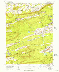
 1955 Sybertsville1957 Print · USGSLuzerne County's rural townships are shown here in the mid-1950s, defined by the prominent ridge of Nescopeck Mountain. Genealogists and local historians can locate family-named sites such as Groover Cem and country landmarks like Brainerd Ch and the Township Sch.4 unique versions available
 - 1955 Map of Shickshinny, 1960 Print
 1955 Shickshinny1960 Print · USGSThe Susquehanna River valley and the anthracite coal region appear in fine detail during the mid-fifties. Researchers can trace old rail corridors, family cemeteries like St Alberts Cem, and smaller settlements such as Mocanaqua or Patterson Grove.
 - 1955 Map of Mahanoy, 1960 Print
 1955 Mahanoy1960 Print · USGSThe anthracite coalfields of Schuylkill County are shown in full industrial operation during the mid-1950s. Researchers can locate specific colliery sites and landmarks like Harwood, the Mahanoy Tunnel, and the lone Peddlars Grave.
 - 1956 Map of Newark
 1956 Newark1956 Print · USGSThe industrial heart of the Mid-Atlantic is captured here at the dawn of the highway era, tracing the dense corridors between Newark and Philadelphia. Genealogists and local historians can map the rail networks of the Reading RR or locate mid-century military life at Fort Dix Military Reservation.2 unique versions available
 - 1957 Map of Harrisburg
 1957 Harrisburg1957 Print · USGSMid-century Central Pennsylvania comes into focus as a bustling network of rail, river, and mountain ridges. Genealogists and historians can trace the development of the State Capitol and surrounding hubs like Middletown, Columbia, and Pottsville.7 unique versions available
 - 1957 Map of Newark
 1957 Newark1957 Print · USGSThe industrial and military heart of the Mid-Atlantic is mapped during its post-war suburban boom. Genealogists and historians can trace the intricate rail corridors of the Reading Railroad and locate key landmarks from Princeton University to Fort Hancock.
Showing maps 1-25 of 26
Top cities of Luzerne County
- Wilkes-Barre historical maps
- Hazleton historical maps
- Kingston historical maps
- Nanticoke historical maps
- Plains Township historical maps
- Dallas Township historical maps
See more
Frequently asked questions
- What are the different types of historical maps available for Luzerne County?
- What is the oldest map of Luzerne County?
- Where can I purchase historical maps of Luzerne County for my home or office?
- Where can I download high-res historical maps of Luzerne County?
- Are there historical topographic maps available for Luzerne County?
- Is there historical aerial imagery available for Luzerne County?
- Where are historical maps of Luzerne County sourced from?