1960s Maps of Luzerne County, Pennsylvania
Explore 15 historic maps of Luzerne County from the 1960s. These maps offer a rare glimpse into what life looked like during the 1960s — showing old roads, neighborhoods, homes, and landmarks that have changed or disappeared over time.
Whether you're researching your family's past, planning a metal detecting trip, or studying how Luzerne County's landscape evolved across the 1960s, these high-resolution maps are a powerful tool for exploring the history of this region.
- Focus on a specific era: All maps on this page are from the 1960s, giving you a focused view of this time period.
- See what’s changed: Compare century-old streets, trails, and buildings to today's modern landscape using overlays and satellite layers.
- Research with precision: Use these maps for genealogy, historical research, land use analysis, or educational projects.
- View, download, or print: Maps are fully viewable online in high resolution, and can be downloaded or printed for your own records.
Start exploring Luzerne County's history through authentic maps from the 1960s. This is your window into the past.
Luzerne County, PA maps
(15)- 1960 Map of Williamsport
 1960 Williamsport1960 Print · USGSNorth-central Pennsylvania in the mid-twentieth century was a vital corridor of rail and river industry stretching from the New York line to the coal regions. Genealogists can trace the rail networks of the Pennsylvania RR and Lehigh Valley RR connecting towns like Williamsport, Towanda, and Lock Haven.
 - 1960 Map of Newark
 1960 Newark1960 Print · USGSThe industrial heart of the Mid-Atlantic is shown at mid-century, stretching from the dense urban centers of Newark and Philadelphia to the Blue Mountain ridges. Researchers can trace historic rail lines, coastal defenses at Fort Hancock, and the riverfront growth of Trenton and Easton.3 unique versions available
 - 1961 Map of Harrisburg
 1961 Harrisburg1961 Print · USGSCentral Pennsylvania is shown at a mid-century peak of industrial and military activity, from the Susquehanna water gaps to the fertile Dutch Country. Genealogists and historians can trace the rail corridors of the Pennsylvania RR and find landmarks like Carlisle Barracks or the Anthracite Coal Fields.2 unique versions available
 - 1962 Map of Williamsport, 1966 Print
 1962 Williamsport1966 Print · USGSNorth-central Pennsylvania was a landscape of industrial river hubs and vast state woodlands in the early sixties. Researchers can trace the path of the Pennsylvania Railroad through Williamsport and explore the remote reaches of Bucktail State Park.5 unique versions available
 - 1962 Map of Scranton, 1977 Print
 1962 Scranton1977 Print · USGSThe industrial heart of eastern Pennsylvania and the New York Catskills are captured here in the early sixties. Genealogists and historians can trace the dense valley settlements from Scranton to Wilkes-Barre and the rail lines of the Erie Lackawanna Railroad.2 unique versions available
 - 1964 Map of Newark
 1964 Newark1964 Print · USGSGreater New Jersey and eastern Pennsylvania appear at the peak of their industrial and rail-centered development in the mid-sixties. Genealogists and historians can trace the paths of the Pennsylvania RR, identify mid-century landmarks like CAMP KILMER, or follow the Schuylkill River through READING.2 unique versions available
 - 1964 Map of Harrisburg
 1964 Harrisburg1964 Print · USGSCentral Pennsylvania in the mid-fifties reveals a landscape shaped by ridge-and-valley geology and critical Cold War infrastructure. Researchers can trace the massive Indiantown Gap Military Reservation or the rail corridors of the Pennsylvania RR and Reading RR.
 - 1965 Map of Scranton
 1965 Scranton1965 Print · USGSThe tri-state highlands of Pennsylvania, New York, and New Jersey come alive in the mid-sixties as industry and recreation converge. Trace the intricate rail lines of the Erie Lackawanna RR or locate landmarks like the U S Military Academy.2 unique versions available
 - 1965 Map of Williamsport
 1965 Williamsport1965 Print · USGSNorth-central Pennsylvania in the mid-1960s is defined by the industrial river towns and vast timberlands of the Allegheny Plateau. Researchers can trace historic rail lines like the Erie Lackawanna and Reading as they thread through Williamsport, Lock Haven, and Jersey Shore.
 - 1965 Map of Thornhurst, 1967 Print
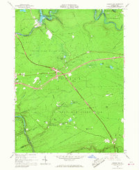
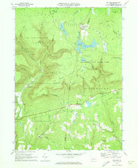
 1965 Thornhurst1967 Print · USGSThe Lehigh River corridor near Thornhurst shows a landscape of public forests and wetlands in the mid-1960s. Researchers can locate burial grounds like Pine Grove Cem and explore named swales such as City of Rome Dark Swamp.6 unique versions available
 - 1965 Map of Pleasant View Summit, 1967 Print
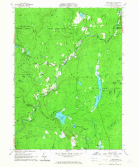
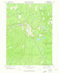
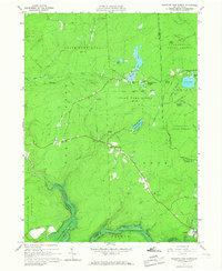 1965 Pleasant View Summit1967 Print · USGSThe Luzerne County highlands in the mid-sixties are shown here as a landscape of conservation and water management. You can trace the Francis E Walter Reservoir, the historic settlement at Stoddartsville, and an Old Railroad Grade.4 unique versions available
 - 1966 Map of Williamsport
 1966 Williamsport1966 Print · USGSThe Susquehanna Valley was a hub of transit and industry in the mid-seventies, where the river's West Branch connected major college towns and timberlands. Researchers can trace historical rail lines like the Reading or locate regional landmarks from Jersey Shore to Ricketts Glen State Park.
 - 1966 Map of Hickory Run, 1967 Print
 1966 Hickory Run1967 Print · USGSCarbon County is captured during its mid-century transition into a recreational hub as the new interstate highway system intersects old mountain roads. Trace the evolution of this landscape from the Central Railroad of New Jersey to the Boulder Field and Hickory Run State Park.3 unique versions available
 - 1969 Map of Red Rock, 1973 Print
 1969 Red Rock1973 Print · USGSThe high plateau of the Endless Mountains is captured in the late sixties, showing the Cold War presence of the Benton Air Force Station. Genealogists and historians can trace the remote settlements of Jamison City, Central, and Mossville alongside the waterfalls of Ricketts Glen State Park.4 unique versions available
 - 1969 Map of Lopez, 1973 Print
 1969 Lopez1973 Print · USGSSullivan County’s high plateaus and creek valleys are captured here in the late sixties as conservation lands began to surround older industrial sites. Researchers can trace the Old Railroad Grade near Lopez or locate family sites at St Vladimirs Cem and Murray.5 unique versions available
End of results
Showing maps 1-15 of 15
Top cities of Luzerne County
- Wilkes-Barre historical maps
- Hazleton historical maps
- Kingston historical maps
- Nanticoke historical maps
- Plains Township historical maps
- Dallas Township historical maps
See more
Frequently asked questions
- What are the different types of historical maps available for Luzerne County?
- What is the oldest map of Luzerne County?
- Where can I purchase historical maps of Luzerne County for my home or office?
- Where can I download high-res historical maps of Luzerne County?
- Are there historical topographic maps available for Luzerne County?
- Is there historical aerial imagery available for Luzerne County?
- Where are historical maps of Luzerne County sourced from?