1970s Maps of Jackson Township, Pennsylvania
Explore 4 historic maps of Jackson Township from the 1970s. These maps offer a rare glimpse into what life looked like during the 1970s — showing old roads, neighborhoods, homes, and landmarks that have changed or disappeared over time.
Whether you're researching your family's past, planning a metal detecting trip, or studying how Jackson Township's landscape evolved across the 1970s, these high-resolution maps are a powerful tool for exploring the history of this region.
- Focus on a specific era: All maps on this page are from the 1970s, giving you a focused view of this time period.
- See what’s changed: Compare century-old streets, trails, and buildings to today's modern landscape using overlays and satellite layers.
- Research with precision: Use these maps for genealogy, historical research, land use analysis, or educational projects.
- View, download, or print: Maps are fully viewable online in high resolution, and can be downloaded or printed for your own records.
Start exploring Jackson Township's history through authentic maps from the 1970s. This is your window into the past.
Jackson Township, PA maps
(4)- 1976 Map of Mount Pocono, 1978 Print
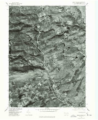 1976 Mount Pocono1978 Print · USGSMonroe County was undergoing significant land-use changes in the mid-seventies, as seen in this detailed aerial orthophotomap. Genealogists and local historians can trace property developments and road networks near Tannersville, Bartonsville, and Mount Pocono.
 - 1976 Map of Saylorsburg, 1978 Print
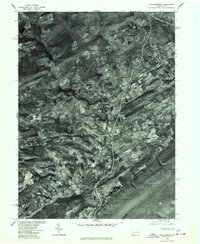 1976 Saylorsburg1978 Print · USGSThe Monroe County countryside appears in photographic detail during the mid-seventies, showing the intersection of ridge-top forests and valley farms. Genealogists and land researchers can trace exact property layouts around Saylorsburg, Sciota, and Snydersville.
 - 1976 Map of Pocono Pines, 1978 Print
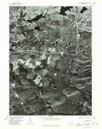 1976 Pocono Pines1978 Print · USGSThe Pocono Mountains landscape in the mid-seventies reveals a mix of dense forest and growing recreational communities. Genealogists and local historians can trace the footprint of Pocono Pines and the early development surrounding Pocono Lake and Crescent Lake.
 - 1976 Map of Broadheadsville, 1979 Print
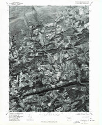 1976 Broadheadsville1979 Print · USGSMonroe County's rural landscape is captured here during the late 1970s through detailed aerial photography. You can trace the development of crossroads settlements like Effort, Gilbert, and the expanding community of Sun Valley.
End of results
Showing maps 1-4 of 4
Top cities near Jackson Township
- East Stroudsburg historical maps
- Tobyhanna historical maps
- Stroudsburg historical maps
- Bangor historical maps
- Pen Argyl historical maps
- Mount Pocono historical maps
See more
Top neighborhoods of Jackson Township
- Reeders historical maps
- Wooded Acres historical maps
- Appenzell historical maps
- Neola historical maps
- Jackson Heights historical maps
- Northridge historical maps
See more
Frequently asked questions
- What are the different types of historical maps available for Jackson Township?
- What is the oldest map of Jackson Township?
- Where can I purchase historical maps of Jackson Township for my home or office?
- Where can I download high-res historical maps of Jackson Township?
- Are there historical topographic maps available for Jackson Township?
- Is there historical aerial imagery available for Jackson Township?
- Where are historical maps of Jackson Township sourced from?