1900s (20th Century) Maps of Northumberland County, Pennsylvania
Explore 66 historic maps of Northumberland County from the 1900s (20th Century). These maps offer a rare glimpse into what life looked like during the 1900s — showing old roads, neighborhoods, homes, and landmarks that have changed or disappeared over time.
Whether you're researching your family's past, planning a metal detecting trip, or studying how Northumberland County's landscape evolved across the 1900s, these high-resolution maps are a powerful tool for exploring the history of this region.
- Focus on a specific era: All maps on this page are from the 1900s, giving you a focused view of this time period.
- See what’s changed: Compare century-old streets, trails, and buildings to today's modern landscape using overlays and satellite layers.
- Research with precision: Use these maps for genealogy, historical research, land use analysis, or educational projects.
- View, download, or print: Maps are fully viewable online in high resolution, and can be downloaded or printed for your own records.
Start exploring Northumberland County's history through authentic maps from the 1900s. This is your window into the past.
Northumberland County, PA maps
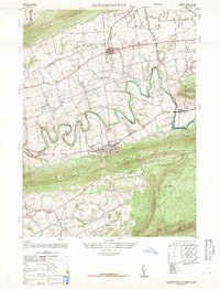
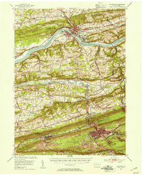
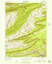
(66)- 1924 Map of Milton
 1924 Milton1924 Print · USGSNorthumberland and Lycoming counties thrived along the river during the 1920s, dominated by a dense network of mountain ridges and rail corridors. Genealogists can locate dozens of rural landmarks, from the Old Furnace to the Stone Church and Pioneer School.4 unique versions available
 - 1935 Map of Hughesville
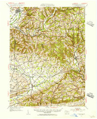
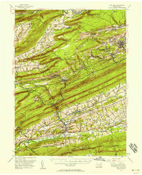
 1935 Hughesville1935 Print · USGSThe rural landscapes of Lycoming and Columbia counties are captured here in the mid-1930s, documenting a time when small schoolhouses and family farms still defined the region. Researchers can trace the Pennsylvania rail line and locate ancestral sites like Wintersteen Sch, Exchange, and Washingtonville.3 unique versions available
 - 1943 Map of Millersburg
 1943 Millersburg1943 Print · USGSDauphin and Northumberland counties appear here during the mid-1940s, defined by the river-and-rail economy along the Susquehanna River. Researchers can trace the heritage of small valley towns through landmarks like St Johns Church, Morning Glory School, and the Limestone Quarries.
 - 1943 Map of Lykens
 1943 Lykens1943 Print · USGSDauphin and Schuylkill counties are shown in the 1940s as a high-density corridor of anthracite coal production and valley farming. Genealogists and industrial historians can trace the Reading rail lines connecting Williamstown to an Abandoned Colliery and rural landmarks like Himmels Ch.
 - 1943 Map of Shamokin
 1943 Shamokin1943 Print · USGSNorthumberland and Montour Counties were hubs of industry and river trade in the 1940s. Genealogists and historians can trace rail-era landmarks like Wolverton Station and coal-country staples such as the Trevorton Colliery and Zion Church.
 - 1943 Map of Sunbury
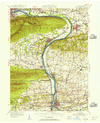
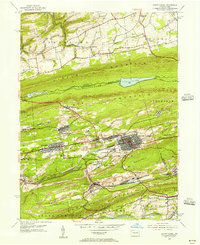
 1943 Sunbury1943 Print · USGSDuring the mid-1940s, the Susquehanna River valley functioned as a vital corridor for both higher education and heavy industry. Genealogists can trace family roots through numerous country schools like Ulrich School and landmarks such as Hummels Wharf or the Isle of Que.
 - 1947 Map of Elizabethville
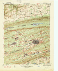
 1947 Elizabethville1947 Print · USGSPost-war Dauphin County unfolds across the Lykens Valley in this mid-century survey of rural townships and mountain ridges. Genealogists can trace family roots through numerous local landmarks like Maple Grove Cem, Straw Church & Cem, and the Pennsylvania RR corridor.2 unique versions available
 - 1947 Map of Millersburg
 1947 Millersburg1947 Print · USGSThe Susquehanna River valley and the ridges of Central Pennsylvania are captured here just after the war. Local historians can trace family sites like Killinger School, navigate the Millersburg Ferry, and locate old river crossings such as Montgomery Ferry.2 unique versions available
 - 1947 Map of Klingerstown
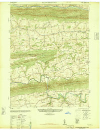 1947 Klingerstown1947 Print · USGSThe rural borderlands of Northumberland and Schuylkill counties are captured here just after the war. Genealogists can trace family names through landmarks like St Peters-Himmels Church, the Kissingers School, and the village of Rough and Ready.2 unique versions available
 - 1947 Map of Mt. Carmel
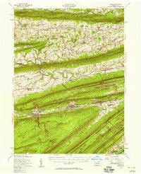
 1947 Mt. Carmel1947 Print · USGSThe Pennsylvania coal region is shown here at its post-war industrial peak, bounded by the ridges of Big Mountain and Locust Mountain. Genealogists and historians can trace the intricate rail networks and compact neighborhoods of Mount Carmel, Kulpmont, and Locust Summit.2 unique versions available
 - 1947 Map of Pillow
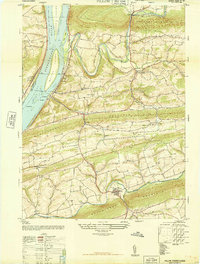 1947 Pillow1947 Print · USGSThe river and ridge country of Dauphin and Northumberland Counties comes alive in this post-war survey. Genealogists can trace family roots through numerous local landmarks like Withers School, St Pauls Church, and the riverfront at Port Trevorton.3 unique versions available
 - 1947 Map of Valley View
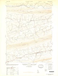 1947 Valley View1947 Print · USGSSchuylkill County communities are captured here in the late 1940s, nestled in the long valleys between the steep ridges of the Appalachians. Family historians can locate family landmarks such as Hepler, the Pitman School, and St Pauls Union Church.3 unique versions available
 - 1947 Map of Dalmatia
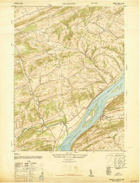 1947 Dalmatia1947 Print · USGSThe Susquehanna River corridor in the late 1940s serves as a vital artery for the Pennsylvania Railroad and the historic Susquehanna Trail. Genealogists and local historians can trace family roots through numerous rural landmarks like Aline School, Bot Schafts Church, and the riverfront village of Dalmatia.2 unique versions available
 - 1947 Map of Tremont
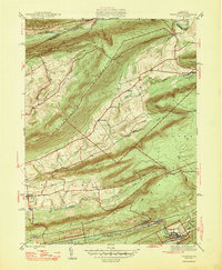 1947 Tremont1947 Print · USGSSchuylkill County is shown here in the late 1940s, where rail lines and mountain ridges dictate the flow of local life. Researchers can trace the Reading railroad corridor through Tremont or locate rural landmarks like Salem Ch and Beury Lake.2 unique versions available
 - 1950 Map of Harrisburg, 1952 Print
 1950 Harrisburg1952 Print · USGSMid-century Central Pennsylvania comes alive through its dense rail networks and river valley settlements during the post-war industrial era. Genealogists and historians can trace family roots through hubs like Harrisburg, locate Carlisle Barracks, or follow the Pennsylvania RR through the Lebanon Valley.
 - 1952 Map of Shamokin, 1954 Print
 1952 Shamokin1954 Print · USGSNorthumberland County in the early 1950s shows a landscape defined by the Susquehanna River and the coal-rich ridges of Big Mountain. Genealogists can locate family names at Pine Hill Cem or trace landmarks like the Slovac Academy and Geisinger Hospital.3 unique versions available
 - 1953 Map of Hughesville, 1956 Print
 1953 Hughesville1956 Print · USGSThe rural heart of Lycoming and Columbia Counties is captured here in the early fifties, showing a landscape defined by small townships and creek-side settlements. Researchers can locate vanished rural landmarks like Frenchtown Sch, Hendrickson Ch, and the streets of Washingtonville or Jerseytown.3 unique versions available
 - 1953 Map of Millersburg, 1956 Print
 1953 Millersburg1956 Print · USGSCentral Pennsylvania's river valleys and mountain ridges are captured here during the early fifties, showing a landscape defined by the Susquehanna River. Researchers can locate vanished landmarks like the Abandoned Canal, the Oakdale Sta, and numerous country schools including Keiters Sch.3 unique versions available
 - 1953 Map of Sunbury, 1956 Print
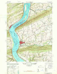
 1953 Sunbury1956 Print · USGSThe Susquehanna River Valley in the early fifties shows a bustling corridor of rail, industry, and academia. Genealogists can trace family names at Stoltzfus Cem, explore the grounds of Bucknell University, or locate the historic Joseph Priestley Home.3 unique versions available
 - 1953 Map of Milton, 1956 Print
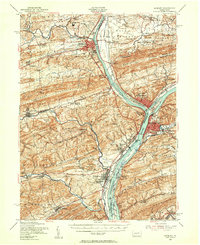
 1953 Milton1956 Print · USGSThe Susquehanna Valley thrives during the early fifties, defined by its river-town industries and coal-hauling rail lines. Genealogists can trace family names through country landmarks like Stone Church, Old Furnace, and the U S Military Reservation.2 unique versions available
 - 1954 Map of Williamsport
 1954 Williamsport1954 Print · USGSNorth-central Pennsylvania in the mid-fifties is defined by the winding West Branch Susquehanna River and its industrial valley. Local historians can trace the massive Susquehanna Ordnance Depot and the extensive rail networks of the Pennsylvania Railroad.
 - 1954 Map of Tremont, 1956 Print
 1954 Tremont1956 Print · USGSSchuylkill County in the mid-fifties shows a landscape defined by the anthracite valleys and the parallel ridges of the Appalachians. Researchers can trace the READING rail lines through Tremont and Donaldson, or locate family landmarks like Salem Ch and Klingers Sch.4 unique versions available
 - 1955 Map of Mount Carmel, 1956 Print
 1955 Mount Carmel1956 Print · USGSNorthumberland County's coal-country landscape is meticulously detailed here in the mid-fifties, showing the rail-dependent corridor between Kulpmont and Mount Carmel. Genealogists and historians can trace the foundations of local life through the Township Sch, Mount Carmel Cemetery, and the Drive-in Theater at Natalie.5 unique versions available
 - 1955 Map of Lykens, 1958 Print
 1955 Lykens1958 Print · USGSThe anthracite coal valleys of Dauphin and Schuylkill counties are shown here in the mid-1950s, a time of transition for the region's industrial landscape. Genealogists can trace family roots through numerous country landmarks like Himmels Ch, Kissingers Sch, and the Pitman Post Office.2 unique versions available
 - 1955 Map of Pine Grove, 1958 Print
 1955 Pine Grove1958 Print · USGSSchuylkill County coal towns and the Blue Mountain ridges are documented here in the mid-1950s. Genealogists and researchers can locate family-named landmarks like Klingers Sch and Hauer Ch alongside coal-era infrastructure like Coal Castle.3 unique versions available
Showing maps 1-25 of 66
Top cities of Northumberland County
- Sunbury historical maps
- Shamokin historical maps
- Mount Carmel historical maps
- Northumberland historical maps
- Kulpmont historical maps
- Riverside historical maps
See more
Frequently asked questions
- What are the different types of historical maps available for Northumberland County?
- What is the oldest map of Northumberland County?
- Where can I purchase historical maps of Northumberland County for my home or office?
- Where can I download high-res historical maps of Northumberland County?
- Are there historical topographic maps available for Northumberland County?
- Is there historical aerial imagery available for Northumberland County?
- Where are historical maps of Northumberland County sourced from?