1990s Maps of Northumberland County, Pennsylvania
Explore 8 historic maps of Northumberland County from the 1990s. These maps offer a rare glimpse into what life looked like during the 1990s — showing old roads, neighborhoods, homes, and landmarks that have changed or disappeared over time.
Whether you're researching your family's past, planning a metal detecting trip, or studying how Northumberland County's landscape evolved across the 1990s, these high-resolution maps are a powerful tool for exploring the history of this region.
- Focus on a specific era: All maps on this page are from the 1990s, giving you a focused view of this time period.
- See what’s changed: Compare century-old streets, trails, and buildings to today's modern landscape using overlays and satellite layers.
- Research with precision: Use these maps for genealogy, historical research, land use analysis, or educational projects.
- View, download, or print: Maps are fully viewable online in high resolution, and can be downloaded or printed for your own records.
Start exploring Northumberland County's history through authentic maps from the 1990s. This is your window into the past.
Northumberland County, PA maps
(8)- 1994 Map of Lewisburg, 1996 Print
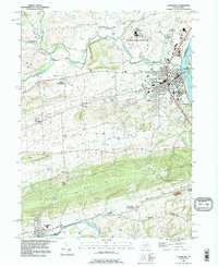 1994 Lewisburg1996 Print · USGSThe West Branch Susquehanna River corridor in the mid-1990s showcases a blend of college-town life and traditional rural valleys. Trace the historic footprint of Bucknell University or locate family sites like Stoltzfus Cem and the Dreisbach Ch.
 - 1994 Map of Montoursville South, 1996 Print
 1994 Montoursville South1996 Print · USGSLycoming County in the mid-1990s shows a complex landscape where the Susquehanna River valley meets the northern Appalachian ridges. Researchers can trace historic riverfront growth and institutional sites like the Allenwood Prison Camp and the Pennsylvania College of Technology.
 - 1994 Map of Danville, 1996 Print
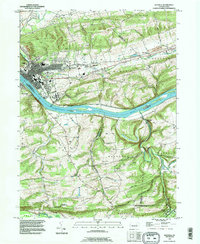 1994 Danville1996 Print · USGSDanville and the winding Susquehanna River corridor appear in the mid-1990s, revealing a landscape of ridge-top farms and riverbank industry. Genealogists can locate family landmarks like Wilson Cem, Straub Ch, and the grounds of the State Hospital.
 - 1994 Map of Northumberland, 1996 Print
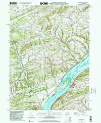
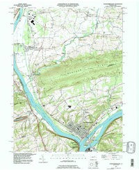 1994 Northumberland1996 Print · USGSThe Susquehanna River forks define this central Pennsylvania landscape during the mid-1990s, where river island parks meet industrial and residential growth. Genealogists and historians can trace local landmarks like Sodom Sch (Historic), Mt Zion Ch, and the streets of Northumberland.
 - 1998 Map of Milton, 2000 Print
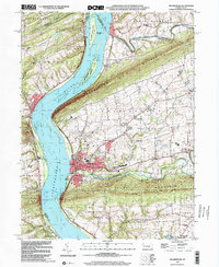
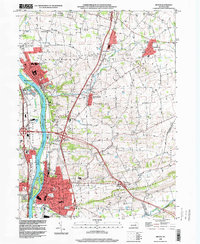 1998 Milton2000 Print · USGSNorthumberland County at the close of the century shows a landscape of river-fronting boroughs and well-preserved rural townships. Family historians can locate several burial grounds like Harmony Cemetery and Chillisquaque Cem or landmarks such as Warrior Run High Sch.
 - 1999 Map of Dalmatia, 2001 Print
 1999 Dalmatia2001 Print · USGSThe Susquehanna River valley at the turn of the millennium shows a landscape of river islands and ridge-side settlements. Researchers can locate vanished rural landmarks and family-named sites like McKees Half Falls, the Covered Bridge near Meiserville, and Grubbs Ch.
 - 1999 Map of Sunbury, 2001 Print
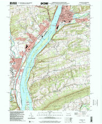 1999 Sunbury2001 Print · USGSNear the close of the century, the river towns of Sunbury and Selinsgrove were centers of commerce and education at the confluence of the Susquehanna and Shamokin Creek. Researchers can trace the grounds of Susquehanna University or find family landmarks like Pomfret Manor Cemetery and Fishers Ferry.
 - 1999 Map of Millersburg, 2001 Print
 1999 Millersburg2001 Print · USGSDauphin County river towns and mountain ridges are captured here at the end of the century. Genealogists and local historians can trace the paths of the Ferry and Montgomery Ferry or locate rural landmarks like St Lukes Ch and the Covered Bridge.
End of results
Showing maps 1-8 of 8
Top cities of Northumberland County
- Sunbury historical maps
- Shamokin historical maps
- Mount Carmel historical maps
- Northumberland historical maps
- Kulpmont historical maps
- Riverside historical maps
See more
Frequently asked questions
- What are the different types of historical maps available for Northumberland County?
- What is the oldest map of Northumberland County?
- Where can I purchase historical maps of Northumberland County for my home or office?
- Where can I download high-res historical maps of Northumberland County?
- Are there historical topographic maps available for Northumberland County?
- Is there historical aerial imagery available for Northumberland County?
- Where are historical maps of Northumberland County sourced from?