1890s Maps of Northumberland County, Pennsylvania
Explore 9 historic maps of Northumberland County from the 1890s. These maps offer a rare glimpse into what life looked like during the 1890s — showing old roads, neighborhoods, homes, and landmarks that have changed or disappeared over time.
Whether you're researching your family's past, planning a metal detecting trip, or studying how Northumberland County's landscape evolved across the 1890s, these high-resolution maps are a powerful tool for exploring the history of this region.
- Focus on a specific era: All maps on this page are from the 1890s, giving you a focused view of this time period.
- See what’s changed: Compare century-old streets, trails, and buildings to today's modern landscape using overlays and satellite layers.
- Research with precision: Use these maps for genealogy, historical research, land use analysis, or educational projects.
- View, download, or print: Maps are fully viewable online in high resolution, and can be downloaded or printed for your own records.
Start exploring Northumberland County's history through authentic maps from the 1890s. This is your window into the past.
Northumberland County, PA maps
(9)- 1892 Map of Catawissa
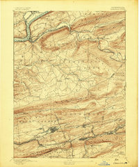
 1892 Catawissa1892 Print · USGSThe Pennsylvania anthracite region comes into focus during the late nineteenth-century coal boom. Genealogists and historians can trace rail-centered towns like Centralia, Ashland, and Mount Carmel alongside the historic Bloomsburg Ferry.
 - 1892 Map of Lykens
 1892 Lykens1892 Print · USGSDauphin and Schuylkill counties are shown here in the late nineteenth century as the coal and rail industries shaped the valley floors. Genealogists can trace family roots in mining centers like Williamstown and Lykens or agricultural hamlets such as Rough and Ready.2 unique versions available
 - 1892 Map of Shamokin
 1892 Shamokin1892 Print · USGSNorthumberland and Montour Counties are shown here during their industrial prime, when coal and rail shaped every valley. Researchers can trace the early footprints of Shamokin and Danville or locate smaller rail stops like Wolverton Station and Paxinos.
 - 1892 Map of Pine Grove
 1892 Pine Grove1892 Print · USGSSchuylkill County coal country comes alive in the late 1800s, showing a landscape defined by sharp ridges and heavy industry. Genealogists and historians can trace rail-dependent mining towns like Minersville, Branch Dale, and the bustling junction at Tremont.10 unique versions available
 - 1893 Map of Sunbury
 1893 Sunbury1893 Print · USGSThe Susquehanna River forks define this late nineteenth-century Pennsylvania landscape during a peak era of rail and canal competition. Researchers can trace historic riverfronts at Sunbury and Northumberland or find old family footprints in Selins Grove, Mazeppa, and Freeburg.6 unique versions available
 - 1893 Map of Lykens
 1893 Lykens1893 Print · USGSThe anthracite coal region of central Pennsylvania comes to life in the late nineteenth century, showing a landscape defined by mountain ridges and mining railways. Local historians can trace the early industrial footprints of Williamstown and Lykens or find rural homesteads near Klingerstown and Leck Kill.7 unique versions available
 - 1893 Map of Shamokin
 1893 Shamokin1893 Print · USGSNorthumberland County's coal-and-rail landscape is captured here during the peak of its industrial development in the late nineteenth century. Researchers can trace the extensive rail networks serving settlements like Shamokin, Danville, and Trevorton, alongside early infrastructure like the Weigh Scale.6 unique versions available
 - 1893 Map of Millersburg
 1893 Millersburg1893 Print · USGSThe Susquehanna River valley in the 1890s shows a landscape shaped by competing transport systems and mountain ridges. Trace the path of the Pennsylvania Canal through Liverpool or locate family roots in Millersburg and Elizabethville.7 unique versions available
 - 1894 Map of Catawissa
 1894 Catawissa1894 Print · USGSPennsylvania's anthracite coal region and the Susquehanna valley appear here in the late nineteenth century, defined by a massive expansion of rail and ridge-top settlements. Researchers can trace old transit lines like the Lehigh Valley Railroad through Centralia or locate early rural hubs like Mifflin X Roads.6 unique versions available
End of results
Showing maps 1-9 of 9
Top cities of Northumberland County
- Sunbury historical maps
- Shamokin historical maps
- Mount Carmel historical maps
- Northumberland historical maps
- Kulpmont historical maps
- Riverside historical maps
See more
Frequently asked questions
- What are the different types of historical maps available for Northumberland County?
- What is the oldest map of Northumberland County?
- Where can I purchase historical maps of Northumberland County for my home or office?
- Where can I download high-res historical maps of Northumberland County?
- Are there historical topographic maps available for Northumberland County?
- Is there historical aerial imagery available for Northumberland County?
- Where are historical maps of Northumberland County sourced from?