1970s Maps of Northumberland County, Pennsylvania
Explore 4 historic maps of Northumberland County from the 1970s. These maps offer a rare glimpse into what life looked like during the 1970s — showing old roads, neighborhoods, homes, and landmarks that have changed or disappeared over time.
Whether you're researching your family's past, planning a metal detecting trip, or studying how Northumberland County's landscape evolved across the 1970s, these high-resolution maps are a powerful tool for exploring the history of this region.
- Focus on a specific era: All maps on this page are from the 1970s, giving you a focused view of this time period.
- See what’s changed: Compare century-old streets, trails, and buildings to today's modern landscape using overlays and satellite layers.
- Research with precision: Use these maps for genealogy, historical research, land use analysis, or educational projects.
- View, download, or print: Maps are fully viewable online in high resolution, and can be downloaded or printed for your own records.
Start exploring Northumberland County's history through authentic maps from the 1970s. This is your window into the past.
Northumberland County, PA maps
(4)- 1977 Map of Tremont, 1979 Print
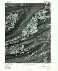 1977 Tremont1979 Print · USGSSchuylkill County's ridge-and-valley landscape is captured in the late seventies through detailed aerial imagery. Trace the development of valley settlements like Hegins and Donaldson alongside the industrial corridors of Broad Mountain.
 - 1977 Map of Dalmatia, 1979 Print
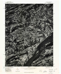 1977 Dalmatia1979 Print · USGSThe Susquehanna River valley and its complex ridge-side farms are captured here in the late seventies. Researchers can trace the layout of small crossroads settlements like Meiservill and Verdilla or follow the path of Mahantango Creek.
 - 1977 Map of Millersburg, 1979 Print
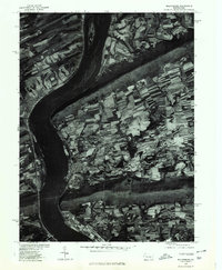 1977 Millersburg1979 Print · USGSThe Susquehanna River valley near the end of the 1970s shows a landscape of riverfront towns and ridge-top forests. Trace the historic layouts of Millersburg, Lenkerville, and Liverpool set against Mahantango Mountain.
 - 1977 Map of Mount Carmel, 1979 Print
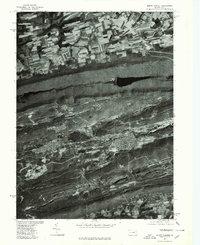 1977 Mount Carmel1979 Print · USGSMount Carmel and the anthracite coal region appear here in the late seventies, captured in detailed aerial imagery. Genealogists and historians can trace the gridded streets of Mount Carmel, Kulpmont, and Locust Gap against the ridges of Big Mountain.
End of results
Showing maps 1-4 of 4
Top cities of Northumberland County
- Sunbury historical maps
- Shamokin historical maps
- Mount Carmel historical maps
- Northumberland historical maps
- Kulpmont historical maps
- Riverside historical maps
See more
Frequently asked questions
- What are the different types of historical maps available for Northumberland County?
- What is the oldest map of Northumberland County?
- Where can I purchase historical maps of Northumberland County for my home or office?
- Where can I download high-res historical maps of Northumberland County?
- Are there historical topographic maps available for Northumberland County?
- Is there historical aerial imagery available for Northumberland County?
- Where are historical maps of Northumberland County sourced from?