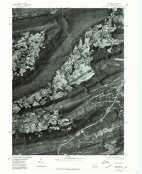
1977 Map of Tremont
USGS Topo · Published 1979About this map
The distinct parallel ridges of the Pennsylvania coal region define the landscape in this 1977 orthophotographic study. Line Mountain, Mahantango Mountain, and Broad Mountain form the physical backbone of the terrain, sandwiching narrow valleys where agriculture and industry coexist. This aerial perspective, produced by the Geological Survey and the Soil Conservation Service, reveals the intricate land-use patterns in the valley between Hegins and Fountain.
Find a feature on this map
9 named features on this map. Tap any name to fly to it.
Don’t see what you’re looking for? This feature index may not catch every label — zoom into the map to look around manually.
Map Details
Editions of this 1977 Tremont Map
This is the sole edition of this map. No revisions or reprints were ever made.
Other maps of this area

1889 · Catawissa
USGS Topo · 1:62,500

1892 · Catawissa
USGS Topo · 1:62,500

1892 · Lykens
USGS Topo · 1:62,500

1892 · Shamokin
USGS Topo · 1:62,500

1892 · Pine Grove
USGS Topo · 1:62,500

1893 · Lykens
USGS Topo · 1:62,500

1893 · Shamokin
USGS Topo · 1:62,500

1894 · Catawissa
USGS Topo · 1:62,500

1943 · Lykens
USGS Topo · 1:62,500

1943 · Shamokin
USGS Topo · 1:62,500