1940s Maps of Conemaugh Township, Pennsylvania
Explore 3 historic maps of Conemaugh Township from the 1940s. These maps offer a rare glimpse into what life looked like during the 1940s — showing old roads, neighborhoods, homes, and landmarks that have changed or disappeared over time.
Whether you're researching your family's past, planning a metal detecting trip, or studying how Conemaugh Township's landscape evolved across the 1940s, these high-resolution maps are a powerful tool for exploring the history of this region.
- Focus on a specific era: All maps on this page are from the 1940s, giving you a focused view of this time period.
- See what’s changed: Compare century-old streets, trails, and buildings to today's modern landscape using overlays and satellite layers.
- Research with precision: Use these maps for genealogy, historical research, land use analysis, or educational projects.
- View, download, or print: Maps are fully viewable online in high resolution, and can be downloaded or printed for your own records.
Start exploring Conemaugh Township's history through authentic maps from the 1940s. This is your window into the past.
Conemaugh Township, PA maps
(3)- 1944 Map of Somerset
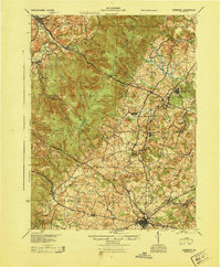 1944 Somerset1944 Print · USGSThe Laurel Highlands during the early years of the Pennsylvania Turnpike are captured here, showing the transition from old mountain roads to modern highways. Genealogists can trace family names at Rector Mill, Rhoads Field, and dozens of local schools like Knepper Sch.
 - 1944 Map of Windber
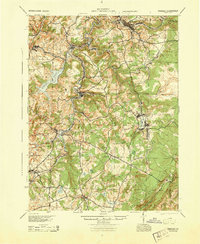 1944 Windber1944 Print · USGSSomerset County's coal and rail corridors are captured here during the 1940s, showing the region's industrial peak. Genealogists can locate family landmarks like Kaufman Ch, Stoystown Sta, and numerous country schools such as Breastwork Sch.
 - 1944 Map of New Florence
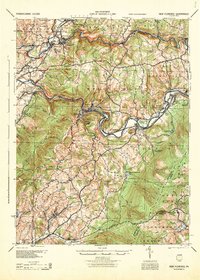 1944 New Florence1944 Print · USGSWestmoreland and Indiana counties during the wartime years reveal a landscape shaped by coal, steam, and rail. Genealogists can trace family footprints in vanished settlements and school districts like Robindale Smokeless PO, Scottglen Sta, and Mahan Sch.
End of results
Showing maps 1-3 of 3
Top cities near Conemaugh Township
- Johnstown historical maps
- Somerset historical maps
- Franklin historical maps
- Westmont historical maps
- Windber historical maps
- Stonycreek Township historical maps
See more
Top neighborhoods of Conemaugh Township
- Foustwell historical maps
- Maple Ridge historical maps
- Thomas Mill historical maps
- Davidsville historical maps
- Krings historical maps
- Tire Hill historical maps
See more
Frequently asked questions
- What are the different types of historical maps available for Conemaugh Township?
- What is the oldest map of Conemaugh Township?
- Where can I purchase historical maps of Conemaugh Township for my home or office?
- Where can I download high-res historical maps of Conemaugh Township?
- Are there historical topographic maps available for Conemaugh Township?
- Is there historical aerial imagery available for Conemaugh Township?
- Where are historical maps of Conemaugh Township sourced from?