1990s Maps of Washington Township, Pennsylvania
Explore 2 historic maps of Washington Township from the 1990s. These maps offer a rare glimpse into what life looked like during the 1990s — showing old roads, neighborhoods, homes, and landmarks that have changed or disappeared over time.
Whether you're researching your family's past, planning a metal detecting trip, or studying how Washington Township's landscape evolved across the 1990s, these high-resolution maps are a powerful tool for exploring the history of this region.
- Focus on a specific era: All maps on this page are from the 1990s, giving you a focused view of this time period.
- See what’s changed: Compare century-old streets, trails, and buildings to today's modern landscape using overlays and satellite layers.
- Research with precision: Use these maps for genealogy, historical research, land use analysis, or educational projects.
- View, download, or print: Maps are fully viewable online in high resolution, and can be downloaded or printed for your own records.
Start exploring Washington Township's history through authentic maps from the 1990s. This is your window into the past.
Washington Township, PA maps
(2)- 1999 Map of Meshoppen, 2001 Print
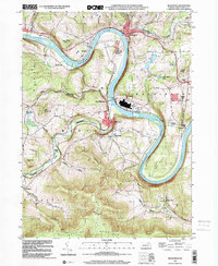 1999 Meshoppen2001 Print · USGSThe Susquehanna River winds through Wyoming County at the turn of the millennium, shaping a landscape of deep valleys and narrow ridge-top settlements. Researchers can locate vanished rural landmarks like Russell Hill Sch, the Vosburg Tunnel, and the remote Mehoopany Fire Tower.
 - 1999 Map of Auburn Center, 2001 Print
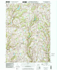 1999 Auburn Center2001 Print · USGSSusquehanna County remains a landscape of high ridges and rural crossroads at the close of the twentieth century. Genealogists can trace family landmarks and burial sites like Boles Cem, Jersey Hill Ch, and the settlement at Auburn Center.
End of results
Showing maps 1-2 of 2
Top cities near Washington Township
- Dallas Township historical maps
- Kingston Township historical maps
- Harveys Lake historical maps
- Bridgewater Township historical maps
- Falls Township historical maps
- Lenox Township historical maps
See more
Top neighborhoods of Washington Township
Frequently asked questions
- What are the different types of historical maps available for Washington Township?
- What is the oldest map of Washington Township?
- Where can I purchase historical maps of Washington Township for my home or office?
- Where can I download high-res historical maps of Washington Township?
- Are there historical topographic maps available for Washington Township?
- Is there historical aerial imagery available for Washington Township?
- Where are historical maps of Washington Township sourced from?