Old Maps of Horry County, South Carolina
Explore 234 old maps of Horry County, spanning from 1937 to today. These high-resolution historic maps reveal how streets, neighborhoods, landmarks, and natural features evolved over time — perfect for genealogy, metal detecting, research, and local history exploration.
What you can do with these maps:
- See how Horry County changed over time: Compare historical maps to modern-day views to trace roads, homesites, rail lines & more.
- View detailed metadata: Each map includes creators, publishers, year, scale, and archive source.
- Overlay maps with satellite & LiDAR: Visualize the past alongside modern tools to explore terrain & human change.
- Trusted historical sources: Maps sourced from the USGS, Library of Congress, and other archives.
- Access maps your way: View online, download high-res files, or order prints for personal or research use.
Start exploring old maps of Horry County to uncover forgotten places, hidden landmarks, and the deep history beneath your feet.
Horry County, SC maps
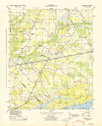
(234)- 1937 Map of Myrtle Beach
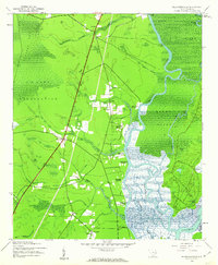
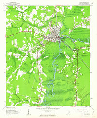
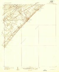 1937 Myrtle Beach1937 Print · USGSThe Grand Strand is seen here in the late 1930s as a developing coastal corridor transitioning from swampy lowlands to a vacation destination. Trace early infrastructure including the Intracoastal Waterway, Myrtle Beach State Park, and the CCC Camp.3 unique versions available
 - 1937 Map of Nixonville
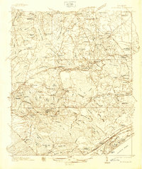 1937 Nixonville1937 Print · USGSCoastal South Carolina is depicted just before the war as a landscape of river landings and rural schoolhouses. Researchers can locate family landmarks like Graham Cem, identify the location of the Chain Gang Shanty, and trace the path of the Atlantic Coast Line.2 unique versions available
 - 1940 Map of Myrtle Beach
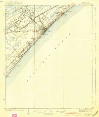 1940 Myrtle Beach1940 Print · USGSBefore the rise of modern resorts, the Grand Strand was a network of swashes and small coastal outposts. Genealogists and historians can trace the early footprints of Socastee, Myrtle Ridge, and the Ocean Forest Club along the historic Kings Highway.3 unique versions available
 - 1942 Map of Nixonville
 1942 Nixonville1942 Print · USGSCoastal South Carolina was a landscape of river landings and remote wetlands in the late thirties. Researchers can trace family roots through numerous local landmarks like Hickory Grove Sch, Mt Calvary Ch, and Reeves Log along the Waccamaw River.2 unique versions available
 - 1943 Map of Pages Mill
 1943 Pages Mill1943 Print · USGSThe Carolina borderlands come alive in the 1940s, showing a landscape shaped by the Lumber River and the Atlantic Coast Line railroad. Genealogists can trace family names through numerous rural landmarks like Oliver Cross Roads, Tabernacle Ch, and White Pond Ch & Sch.
 - 1943 Map of Little River
 1943 Little River1943 Print · USGSThe coastal border between Horry County and Brunswick County is captured here in the early 1940s, highlighting a landscape of tidal marshes and barrier islands. Researchers can trace the early layout of Little River and find landmarks like The Battery, Goat Island, and Futch Beach.
 - 1943 Map of Pireway
 1943 Pireway1943 Print · USGSCoastal Carolina and the borderlands near the Waccamaw River appear here during the wartime years, showing a landscape defined by expansive swamps and rural bay formations. Genealogists can trace family roots through the Dothans Sch, the Old Tram Road, and local landmarks like Dulah Mormon Church.
 - 1943 Map of Calabash
 1943 Calabash1943 Print · USGSThe coastal borderlands of North Carolina and South Carolina are captured here during the early forties, showing a landscape of dense swamps and timber bays. Genealogists can locate family landmarks like Philadelphia Wesley Church, Hickmans Crossroads, and the school at La Savannah Sch.
 - 1943 Map of Wampee, 1947 Print
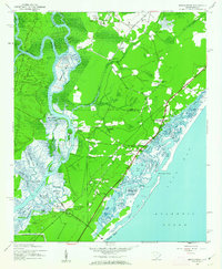
 1943 Wampee1947 Print · USGSCoastal Horry County during the Second World War reveals a landscape shifting from rural swamps to military training grounds and early beach resorts. Genealogists can locate family landmarks like the Matthew Dolan Church or trace the early footprints of Ocean Drive and Wampee.
 - 1943 Map of Yauhannah, 1958 Print
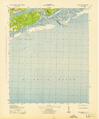
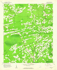
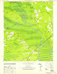 1943 Yauhannah1958 Print · USGSThe South Carolina lowcountry is captured here in the mid-1940s, showing a river-driven landscape of swamps and isolated settlements. Researchers can trace rural life through landmarks like Gravel Gully School, the Yauhannah Church and Cem, and the old Lucas Bay Plantation.4 unique versions available
 - 1943 Map of Bucksville, 1962 Print
 1943 Bucksville1962 Print · USGSThe Lowcountry river system and its transition into a modern waterway define this wartime era map of the Horry County swamplands. Researchers can trace old schoolhouses and rural parishes like Richardson Sch and Hebron Ch along the Waccamaw River.3 unique versions available
 - 1943 Map of Brookgreen, 1962 Print
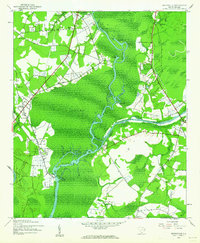
 1943 Brookgreen1962 Print · USGSThe South Carolina Lowcountry comes to life during the early 1940s, showing the intricate wetlands and river landings of the Waccamaw region. Genealogists and historians can trace family locations near Brookgreen Gardens or locate old community hubs like St Peters Ch and Burgess.5 unique versions available
 - 1943 Map of Plantersville, 1962 Print
 1943 Plantersville1962 Print · USGSThe Lowcountry riverfronts of Georgetown County are captured here during the 1940s, showing a landscape of traditional estates and tidal waterways. Genealogists can trace family footprints through numerous river estates like Hasty Point Plantation and rural landmarks such as Prince Frederick Ch or Birdfield Sch.3 unique versions available
 - 1943 Map of Dongola, 1962 Print
 1943 Dongola1962 Print · USGSHorry County during the 1940s reveals a landscape of river-bottom settlements and winding swamp channels. Genealogists can trace family roots through numerous local landmarks like Old Antioch Ch, Singleton Crossroads, and the rural community of Dongola.2 unique versions available
 - 1943 Map of Adrian, 1962 Print
 1943 Adrian1962 Print · USGSCoastal South Carolina is captured here in the early 1940s, showing a world of cypress swamps and railroad hamlets. Researchers can trace the legacy of small communities at Adrian and Homewood, or locate rural landmarks like Mt Aerial Ch and the Old Railroad Grade.2 unique versions available
 - 1943 Map of Horry, 1962 Print
 1943 Horry1962 Print · USGSHorry County at the height of the Second World War reveals a landscape of rural crossroads and extensive swamplands. Researchers can trace the heritage of local congregations and school districts through St Elizabeth Ch, St Matthew Ch, and Brunson Sch.2 unique versions available
 - 1943 Map of Conway, 1962 Print
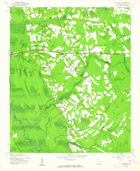
 1943 Conway1962 Print · USGSCoastal South Carolina life during the early 1940s is centered here on the river traffic and rail lines of Conway. Genealogists can trace family roots through numerous country landmarks like Savannah Bluff Ch, Toddville, and the Evergreen Sch.3 unique versions available
 - 1944 Map of Longs
 1944 Longs1944 Print · USGSCoastal South Carolina and North Carolina were defined by river ferries and swamp agriculture during the mid-forties. Genealogists can trace local family landmarks such as Butler Cem, Buck Creek Church, and the former Olyphic PO.
 - 1944 Map of Adrian
 1944 Adrian1944 Print · USGSHorry County at the height of the Second World War shows a rural landscape of family settlements and swamp-bottom timberlands. Genealogists can trace family roots through the Brown Bay Settlement, Thompson Cem, and numerous schools like Cockran School.
 - 1946 Map of Johnsonville
 1946 Johnsonville1946 Print · USGSThe Pee Dee River basin and its surrounding swamplands are captured here in the mid-1940s, showing a landscape defined by river landings and rural crossroads. Genealogists and historians can locate dozens of country churches and schools, from Buzzard Skull Ch to the Gunter Island School.
 - 1947 Map of Centenary
 1947 Centenary1947 Print · USGSMarion County is documented here in the mid-1940s, showing a rural landscape defined by the winding Little Pee Dee River and the Seaboard Air Line railroad. Genealogists can trace family footprints through sites like Beauty Spot Sch, Palmer Cem, and the community of Centenary.3 unique versions available
 - 1948 Map of Galivants Ferry, 1981 Print
 1948 Galivants Ferry1981 Print · USGSThe rural landscape of Horry and Marion counties comes alive in the mid-twentieth century as communities shifted from river landings to crossroads commerce. Genealogists can trace family landmarks and rural school sites like Ketchuptown, Galivants Ferry, and Mill Swamp Sch.
 - 1948 Map of Nichols, 1981 Print
 1948 Nichols1981 Print · USGSMarion and Horry counties are shown here at the mid-century, where the Little Pee Dee River meets the Lumber River. Researchers can trace the river economy through historic landings and crossings like Grice Ferry, Pitch Landing, and Sandy Bluff Bridge.
 - 1948 Map of Bayboro, 1981 Print
 1948 Bayboro1981 Print · USGSHorry County's swampy lowlands are captured here mid-century, showing a landscape defined by small-scale farming and local parishes. Genealogists can locate family landmarks like Martin Cem, Joiner Swamp Sch, and New Hope Ch.
 - 1949 Map of Bayboro
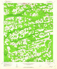
 1949 Bayboro1949 Print · USGSHorry County in the late 1940s was a landscape defined by its wetlands and small rural schoolhouses. Researchers can locate family cemeteries like Graham Cem, community centers like Bayboro, and vanished landmarks such as Athens Sch and Playcards.2 unique versions available
Showing maps 1-25 of 234
Top cities of Horry County
- Myrtle Beach historical maps
- Conway historical maps
- Carolina Forest historical maps
- North Myrtle Beach historical maps
- Surfside Beach historical maps
- Loris historical maps
See more
Frequently asked questions
- What are the different types of historical maps available for Horry County?
- What is the oldest map of Horry County?
- Where can I purchase historical maps of Horry County for my home or office?
- Where can I download high-res historical maps of Horry County?
- Are there historical topographic maps available for Horry County?
- Is there historical aerial imagery available for Horry County?
- Where are historical maps of Horry County sourced from?