1930s Maps of Horry County, South Carolina
Explore 2 historic maps of Horry County from the 1930s. These maps offer a rare glimpse into what life looked like during the 1930s — showing old roads, neighborhoods, homes, and landmarks that have changed or disappeared over time.
Whether you're researching your family's past, planning a metal detecting trip, or studying how Horry County's landscape evolved across the 1930s, these high-resolution maps are a powerful tool for exploring the history of this region.
- Focus on a specific era: All maps on this page are from the 1930s, giving you a focused view of this time period.
- See what’s changed: Compare century-old streets, trails, and buildings to today's modern landscape using overlays and satellite layers.
- Research with precision: Use these maps for genealogy, historical research, land use analysis, or educational projects.
- View, download, or print: Maps are fully viewable online in high resolution, and can be downloaded or printed for your own records.
Start exploring Horry County's history through authentic maps from the 1930s. This is your window into the past.
Horry County, SC maps
(2)- 1937 Map of Myrtle Beach
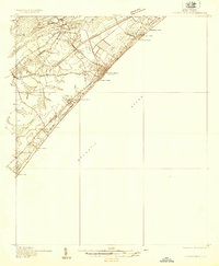 1937 Myrtle Beach1937 Print · USGSThe Grand Strand is seen here in the late 1930s as a developing coastal corridor transitioning from swampy lowlands to a vacation destination. Trace early infrastructure including the Intracoastal Waterway, Myrtle Beach State Park, and the CCC Camp.3 unique versions available
 - 1937 Map of Nixonville
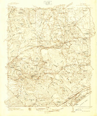 1937 Nixonville1937 Print · USGSCoastal South Carolina is depicted just before the war as a landscape of river landings and rural schoolhouses. Researchers can locate family landmarks like Graham Cem, identify the location of the Chain Gang Shanty, and trace the path of the Atlantic Coast Line.2 unique versions available
End of results
Showing maps 1-2 of 2
Top cities of Horry County
- Myrtle Beach historical maps
- Conway historical maps
- Carolina Forest historical maps
- North Myrtle Beach historical maps
- Surfside Beach historical maps
- Loris historical maps
See more
Frequently asked questions
- What are the different types of historical maps available for Horry County?
- What is the oldest map of Horry County?
- Where can I purchase historical maps of Horry County for my home or office?
- Where can I download high-res historical maps of Horry County?
- Are there historical topographic maps available for Horry County?
- Is there historical aerial imagery available for Horry County?
- Where are historical maps of Horry County sourced from?