1970s Maps of Horry County, South Carolina
Explore 4 historic maps of Horry County from the 1970s. These maps offer a rare glimpse into what life looked like during the 1970s — showing old roads, neighborhoods, homes, and landmarks that have changed or disappeared over time.
Whether you're researching your family's past, planning a metal detecting trip, or studying how Horry County's landscape evolved across the 1970s, these high-resolution maps are a powerful tool for exploring the history of this region.
- Focus on a specific era: All maps on this page are from the 1970s, giving you a focused view of this time period.
- See what’s changed: Compare century-old streets, trails, and buildings to today's modern landscape using overlays and satellite layers.
- Research with precision: Use these maps for genealogy, historical research, land use analysis, or educational projects.
- View, download, or print: Maps are fully viewable online in high resolution, and can be downloaded or printed for your own records.
Start exploring Horry County's history through authentic maps from the 1970s. This is your window into the past.
Horry County, SC maps
(4)- 1971 Map of Little River
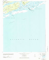 1971 Little River1971 Print · USGSThe coastal border of South Carolina and North Carolina is captured here in the mid-century, before the rise of major seaside resorts. Trace the maritime history of Little River and the winding reaches of Dunn Sound, The Battery, and the Eden Saltworks Cr.
 - 1974 Map of Georgetown, 1978 Print
 1974 Georgetown1978 Print · USGSThe Carolina coast and Pee Dee region are shown here in the mid-seventies, just as the Grand Strand was maturing into a premier destination. Researchers can trace the inland rail corridors of the Seaboard Coast Line Railroad or explore the coastal reaches of the Cape Romain National Wildlife Refuge and Myrtle Beach State Park.2 unique versions available
 - 1976 Map of Fair Bluff, 1978 Print
 1976 Fair Bluff1978 Print · USGSThe Lumber River basin comes into sharp focus during the mid-seventies, showing the intersection of North and South Carolina. Researchers can trace the river's path past Fair Bluff or locate smaller outposts like Marietta and Causey.
 - 1976 Map of Lake View, 1978 Print
 1976 Lake View1978 Print · USGSThe rural landscapes of Dillon County come to life in the mid-1970s, showcasing the agricultural heart of the South Carolina borderlands. Researchers can trace the layout of Lake View and locate outlying communities like Hodgesville and May Hilltop.
End of results
Showing maps 1-4 of 4
Top cities of Horry County
- Myrtle Beach historical maps
- Conway historical maps
- Carolina Forest historical maps
- North Myrtle Beach historical maps
- Surfside Beach historical maps
- Loris historical maps
See more
Frequently asked questions
- What are the different types of historical maps available for Horry County?
- What is the oldest map of Horry County?
- Where can I purchase historical maps of Horry County for my home or office?
- Where can I download high-res historical maps of Horry County?
- Are there historical topographic maps available for Horry County?
- Is there historical aerial imagery available for Horry County?
- Where are historical maps of Horry County sourced from?