1990s Maps of Horry County, South Carolina
Explore 10 historic maps of Horry County from the 1990s. These maps offer a rare glimpse into what life looked like during the 1990s — showing old roads, neighborhoods, homes, and landmarks that have changed or disappeared over time.
Whether you're researching your family's past, planning a metal detecting trip, or studying how Horry County's landscape evolved across the 1990s, these high-resolution maps are a powerful tool for exploring the history of this region.
- Focus on a specific era: All maps on this page are from the 1990s, giving you a focused view of this time period.
- See what’s changed: Compare century-old streets, trails, and buildings to today's modern landscape using overlays and satellite layers.
- Research with precision: Use these maps for genealogy, historical research, land use analysis, or educational projects.
- View, download, or print: Maps are fully viewable online in high resolution, and can be downloaded or printed for your own records.
Start exploring Horry County's history through authentic maps from the 1990s. This is your window into the past.
Horry County, SC maps
(10)- 1990 Map of Brittons Neck
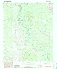 1990 Brittons Neck1990 Print · USGSThe river landings and deep wetlands of the South Carolina Lowcountry are captured here during the late twentieth century. Genealogists and local historians can trace family ties through Brittons Neck and remote river access points like Locust Tree Landing and Hughes Landing.
 - 1990 Map of Myrtle Beach
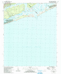
 1990 Myrtle Beach1990 Print · USGSThe Grand Strand and the North Carolina borderlands are captured here in the decade before the base closure. Genealogists and historians can trace the development of Myrtle Beach and North Myrtle Beach alongside rural landmarks like Star Bluff Crossroads and Fort Caswell.
 - 1990 Map of Snow Island
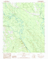 1990 Snow Island1990 Print · USGSThe river-bound territory of Marion and Florence counties is captured in the late twentieth century, showing a landscape of dense swamps and shifting oxbows. Local historians can trace the geography of Snow Island, the reaches of Brittons Neck, and the location of Sampson Landing.
 - 1990 Map of Whiteville
 1990 Whiteville1990 Print · USGSSoutheastern North Carolina and the South Carolina borderlands appear in the late twentieth century, showing a landscape of river-swamps and tobacco towns. Researchers can trace family history through sites like Mount Olive Ch, the Seaboard Coast Line RR, and rural centers like Tabor City.
 - 1990 Map of Calabash, 1991 Print
 1990 Calabash1991 Print · USGSThe North Carolina coast at the turn of the nineties reveals a landscape of quiet crossroads and expanding waterfront communities. Researchers can trace family history through Old Shallotte, Hickmans Crossroads, and numerous burial sites like Manley Bennett Cem.
 - 1990 Map of Pireway, 1991 Print
 1990 Pireway1991 Print · USGSCoastal plain wetlands and small rural settlements define this borderland region in the early nineties. Researchers can trace family history through numerous landmarks like Butler Crossroads, Nakina High Sch, and the Marlowe Cem near the Waccamaw River.
 - 1990 Map of Wampee, 1991 Print
 1990 Wampee1991 Print · USGSThe Grand Strand coastline is mapped here in the early nineties, revealing a balance between burgeoning resort towns and deep-rooted rural communities. Trace local history through the numerous sites like Wampee Ch, Cedar Creek Cem, and the Grand Strand Airport.
 - 1990 Map of Little River, 1991 Print
 1990 Little River1991 Print · USGSThe South Carolina and North Carolina borderlands come alive in the early nineties, showcasing the coastal transition between Little River and Sunset Beach. Local researchers can trace the developed waterfronts of North Myrtle Beach and the shifting sands of Waties Island.
 - 1990 Map of Longs, 1991 Print
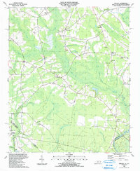
 1990 Longs1991 Print · USGSCoastal plains and river wetlands define the border of North and South Carolina in the late twentieth century. Genealogists and researchers can trace the locations of Worthams Ferry, numerous family cemeteries like Butler Cem, and rural hubs such as Longs and Brooksville.
 - 1994 Map of Myrtle Beach, 1999 Print
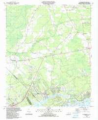
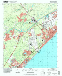 1994 Myrtle Beach1999 Print · USGSCoastal Horry County appears in the mid-1990s as the tourism economy and residential sprawl reshaped the Grand Strand. Genealogists and local historians can trace the footprint of the Myrtle Beach International Airport or locate family sites at Mt Carmel Ch and Socastee.
End of results
Showing maps 1-10 of 10
Top cities of Horry County
- Myrtle Beach historical maps
- Conway historical maps
- Carolina Forest historical maps
- North Myrtle Beach historical maps
- Surfside Beach historical maps
- Loris historical maps
See more
Frequently asked questions
- What are the different types of historical maps available for Horry County?
- What is the oldest map of Horry County?
- Where can I purchase historical maps of Horry County for my home or office?
- Where can I download high-res historical maps of Horry County?
- Are there historical topographic maps available for Horry County?
- Is there historical aerial imagery available for Horry County?
- Where are historical maps of Horry County sourced from?