1940s Maps of Bamberg County, South Carolina
Explore 5 historic maps of Bamberg County from the 1940s. These maps offer a rare glimpse into what life looked like during the 1940s — showing old roads, neighborhoods, homes, and landmarks that have changed or disappeared over time.
Whether you're researching your family's past, planning a metal detecting trip, or studying how Bamberg County's landscape evolved across the 1940s, these high-resolution maps are a powerful tool for exploring the history of this region.
- Focus on a specific era: All maps on this page are from the 1940s, giving you a focused view of this time period.
- See what’s changed: Compare century-old streets, trails, and buildings to today's modern landscape using overlays and satellite layers.
- Research with precision: Use these maps for genealogy, historical research, land use analysis, or educational projects.
- View, download, or print: Maps are fully viewable online in high resolution, and can be downloaded or printed for your own records.
Start exploring Bamberg County's history through authentic maps from the 1940s. This is your window into the past.
Bamberg County, SC maps
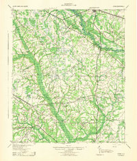
(5)- 1943 Map of Olar
 1943 Olar1943 Print · USGSThe rural Lowcountry around Olar and Ehrhardt appears here during the early 1940s, showing a landscape shaped by river swamps and rail lines. Genealogists can trace family footprints across dozens of sites like Kearse Chapel, Rizers Chapel, and Folk Sch.2 unique versions available
 - 1943 Map of Lodge
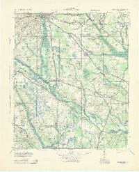
 1943 Lodge1943 Print · USGSThe South Carolina Lowcountry is captured here in the early 1940s at the junction of four counties. Genealogists can trace family roots through numerous rural landmarks like H & B Junction, Hunters Chapel, and the Little Swamp Sch.
 - 1943 Map of Bamberg
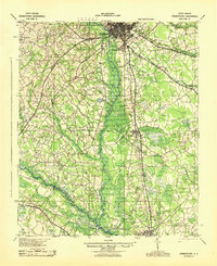
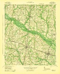 1943 Bamberg1943 Print · USGSMid-century South Carolina comes to life here, showing the intricate rail-and-river network of the Lowcountry. Researchers can locate the Vorhees Institute, trace family ties at Spires Chapel, and find old river access points like Hutto Landing.
 - 1943 Map of Orangeburg
 1943 Orangeburg1943 Print · USGSCoastal plain settlements and river forks define the South Carolina lowcountry during the early war years. Genealogists can trace family landmarks like Bochette Cem, Hunters Chapel Zion Ch, and unique sites like the Indian Field Camp Grounds.
 - 1943 Map of Orangeburg
 1943 Orangeburg1943 Print · USGSThe Orangeburg area in the early 1940s was a critical hub where the Southern and Atlantic Coast Line railroads intersected the Edisto forks. Genealogists can locate numerous rural landmarks like Bryants Academy, Mt Pisgah Ch, and the County Farm.
End of results
Showing maps 1-5 of 5
Top cities of Bamberg County
- Bamberg historical maps
- Denmark historical maps
- Ehrhardt historical maps
- Olar historical maps
- Govan historical maps
Frequently asked questions
- What are the different types of historical maps available for Bamberg County?
- What is the oldest map of Bamberg County?
- Where can I purchase historical maps of Bamberg County for my home or office?
- Where can I download high-res historical maps of Bamberg County?
- Are there historical topographic maps available for Bamberg County?
- Is there historical aerial imagery available for Bamberg County?
- Where are historical maps of Bamberg County sourced from?