1980s Maps of Bamberg County, South Carolina
Explore 10 historic maps of Bamberg County from the 1980s. These maps offer a rare glimpse into what life looked like during the 1980s — showing old roads, neighborhoods, homes, and landmarks that have changed or disappeared over time.
Whether you're researching your family's past, planning a metal detecting trip, or studying how Bamberg County's landscape evolved across the 1980s, these high-resolution maps are a powerful tool for exploring the history of this region.
- Focus on a specific era: All maps on this page are from the 1980s, giving you a focused view of this time period.
- See what’s changed: Compare century-old streets, trails, and buildings to today's modern landscape using overlays and satellite layers.
- Research with precision: Use these maps for genealogy, historical research, land use analysis, or educational projects.
- View, download, or print: Maps are fully viewable online in high resolution, and can be downloaded or printed for your own records.
Start exploring Bamberg County's history through authentic maps from the 1980s. This is your window into the past.
Bamberg County, SC maps
(10)- 1982 Map of Branchville South, 1983 Print
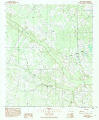
 1982 Branchville South1983 Print · USGSThe Edisto River lowlands were still defined by traditional river crossings and rural church communities in the early 1980s. Researchers can locate family landmarks like Mc Alhany Cem and the river-crossing at Sandy Island Bridge near Branchville.
 - 1982 Map of Branchville North, 1983 Print
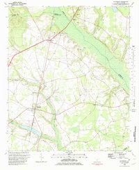
 1982 Branchville North1983 Print · USGSThe rural stretches of Orangeburg County are captured here in the early eighties, centered on the railroad corridor between Rowesville and Branchville. Genealogists can locate several family and church landmarks like Peter Bowman Cem, Byrd Cem, and Cattle Creek Ch.
 - 1982 Map of Tony Hill Bay, 1983 Print
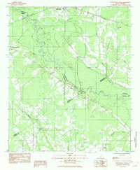
 1982 Tony Hill Bay1983 Print · USGSBamberg and Colleton Counties are captured in the early eighties as a landscape of rural congregations and distinct Carolina bays. Researchers can trace family roots at Prospect Cem and locate numerous local landmarks like Hunters Chapel and Woodlawn Ch.
 - 1982 Map of Olar, 1983 Print
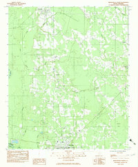
 1982 Olar1983 Print · USGSThe town of Olar and its rural surroundings are captured here in the early eighties, showcasing a landscape defined by the Seaboard Coast Line. Genealogists can trace family landmarks like Sweet Branch Ch, Starr Cem, and the small settlement of Govan.2 unique versions available
 - 1982 Map of Clear Pond, 1983 Print
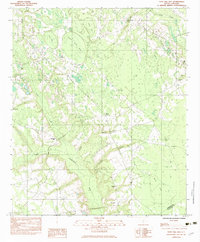
 1982 Clear Pond1983 Print · USGSBamberg County’s riverine landscape is captured in the early eighties as a complex network of swamps and rural community hubs. Researchers can trace family ties and local history through landmarks like Andrew Jackson Academy, Union Ch, and Mitchell Cem.
 - 1982 Map of Sycamore, 1983 Print
 1982 Sycamore1983 Print · USGSThe rural Lowcountry comes into focus in the early 1980s where the Salkehatchie River separates several South Carolina counties. Genealogists and historians can trace rail-side communities like Ulmer and Sycamore or find remote landmarks such as Tutens Millpond and Mizpah Ch.
 - 1982 Map of Lodge, 1983 Print
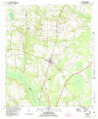
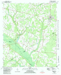
 1982 Lodge1983 Print · USGSThe rural Lowcountry of Colleton and Bamberg counties is captured here in the early 1980s, centered on the village of Lodge. Researchers can trace old family sites and rural landmarks like Goodwin Cem, the Seaboard Coast Line railroad, and Little Swamp Ch.
 - 1982 Map of Ehrhardt, 1983 Print
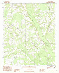
 1982 Ehrhardt1983 Print · USGSThe Salkehatchie River lowlands of the early eighties reveal a landscape of rural crossroads and riverfront history. Researchers can locate family landmarks like the Kearse-Brabham Cem, Lewis Butler Sch, and the historical grounds of Rivers Bridge State Park.
 - 1982 Map of Barnwell, 1984 Print
 1982 Barnwell1984 Print · USGSCoastal plain settlements and a massive nuclear infrastructure meet in South Carolina during the early eighties. Genealogists and historians can trace rail-town development along the Southern line and explore the footprint of the Savannah River Plant Department of Energy.
 - 1985 Map of Saint George, 1986 Print
 1985 Saint George1986 Print · USGSThe South Carolina Lowcountry in the mid-eighties shows a landscape defined by the great reservoirs and the meandering Edisto River. Researchers can trace the rail corridors of the Southern Railway and find rural settlements like Harleyville, Smoaks, and Grover.
End of results
Showing maps 1-10 of 10
Top cities of Bamberg County
- Bamberg historical maps
- Denmark historical maps
- Ehrhardt historical maps
- Olar historical maps
- Govan historical maps
Frequently asked questions
- What are the different types of historical maps available for Bamberg County?
- What is the oldest map of Bamberg County?
- Where can I purchase historical maps of Bamberg County for my home or office?
- Where can I download high-res historical maps of Bamberg County?
- Are there historical topographic maps available for Bamberg County?
- Is there historical aerial imagery available for Bamberg County?
- Where are historical maps of Bamberg County sourced from?