1920s Maps of Bamberg County, South Carolina
Explore 5 historic maps of Bamberg County from the 1920s. These maps offer a rare glimpse into what life looked like during the 1920s — showing old roads, neighborhoods, homes, and landmarks that have changed or disappeared over time.
Whether you're researching your family's past, planning a metal detecting trip, or studying how Bamberg County's landscape evolved across the 1920s, these high-resolution maps are a powerful tool for exploring the history of this region.
- Focus on a specific era: All maps on this page are from the 1920s, giving you a focused view of this time period.
- See what’s changed: Compare century-old streets, trails, and buildings to today's modern landscape using overlays and satellite layers.
- Research with precision: Use these maps for genealogy, historical research, land use analysis, or educational projects.
- View, download, or print: Maps are fully viewable online in high resolution, and can be downloaded or printed for your own records.
Start exploring Bamberg County's history through authentic maps from the 1920s. This is your window into the past.
Bamberg County, SC maps
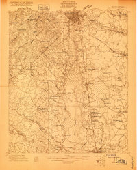
(5)- 1920 Map of Lodge
 1920 Lodge1920 Print · USGSColleton and Bamberg counties at the dawn of the 1920s show a landscape of river-bottom farms and rural junctions. Genealogists can trace the location of early country institutions like Hunters Chapel, Tabernacle School, and the rail crossing at Hampton Branch Junction.
 - 1920 Map of Bamberg
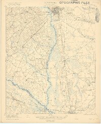
 1920 Bamberg1920 Print · USGSBamberg and Denmark thrived as essential South Carolina railroad junctions during the years following the Great War. Genealogists and local historians can trace rural schoolhouses and landings along the South Fork Edisto River, including the Voorhees Institute, Opossum College, and Old Union Church.2 unique versions available
 - 1920 Map of Orangeburg
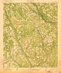
 1920 Orangeburg1920 Print · USGSOrangeburg and the Edisto River valley are captured here at the start of the 1920s, revealing a landscape of small agricultural communities and railroad sidings. Genealogists can locate family landmarks like Bryants Academy, Snake Swamp School, and Cattle Creek Church.
 - 1921 Map of Orangeburg, 1919 Print
 1921 Orangeburg1919 Print · USGSOrangeburg and the Edisto River basin are captured here just after the Great War, during a period of established rail commerce and rural education. Genealogists can trace dozens of schools and churches like Bryants Academy, Sardis School, and Bethel Church.3 unique versions available
 - 1921 Map of Lodge
 1921 Lodge1921 Print · USGSThe Salkehatchie and Edisto river basins come alive in this early 1920s survey of the South Carolina Lowcountry. Researchers can trace rural genealogy and old rail lines through local landmarks like Hunters Chapel, Smoaks, and the Hampton and Branchville RR.3 unique versions available
End of results
Showing maps 1-5 of 5
Top cities of Bamberg County
- Bamberg historical maps
- Denmark historical maps
- Ehrhardt historical maps
- Olar historical maps
- Govan historical maps
Frequently asked questions
- What are the different types of historical maps available for Bamberg County?
- What is the oldest map of Bamberg County?
- Where can I purchase historical maps of Bamberg County for my home or office?
- Where can I download high-res historical maps of Bamberg County?
- Are there historical topographic maps available for Bamberg County?
- Is there historical aerial imagery available for Bamberg County?
- Where are historical maps of Bamberg County sourced from?