1970s Maps of Calhoun County, South Carolina
Explore 6 historic maps of Calhoun County from the 1970s. These maps offer a rare glimpse into what life looked like during the 1970s — showing old roads, neighborhoods, homes, and landmarks that have changed or disappeared over time.
Whether you're researching your family's past, planning a metal detecting trip, or studying how Calhoun County's landscape evolved across the 1970s, these high-resolution maps are a powerful tool for exploring the history of this region.
- Focus on a specific era: All maps on this page are from the 1970s, giving you a focused view of this time period.
- See what’s changed: Compare century-old streets, trails, and buildings to today's modern landscape using overlays and satellite layers.
- Research with precision: Use these maps for genealogy, historical research, land use analysis, or educational projects.
- View, download, or print: Maps are fully viewable online in high resolution, and can be downloaded or printed for your own records.
Start exploring Calhoun County's history through authentic maps from the 1970s. This is your window into the past.
Calhoun County, SC maps
(6)- 1971 Map of Summerton
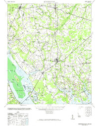 1971 Summerton1971 Print · USGSThe Clarendon County countryside comes alive in this mid-century survey, showing the transition from the Poinsett forest to the shores of Lake Marion. Genealogists can trace family roots through numerous local landmarks like Wells Sch, St Pauls Ch, and the historic Fort Watson.2 unique versions available
 - 1972 Map of Saylors Lake, 1973 Print
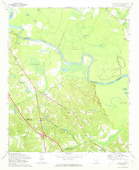 1972 Saylors Lake1973 Print · USGSThe Congaree River valley in the early 1970s reveals a landscape of oxbow lakes and rural settlements along the Calhoun and Lexington county lines. Genealogists can locate numerous local landmarks like Sandy Run Ch, Oak Grove Cem, and Mt Zion Ch.2 unique versions available
 - 1972 Map of Fort Jackson South, 1973 Print
 1972 Fort Jackson South1973 Print · USGSRichland County undergoes significant postwar expansion in the early seventies as the capital city grows toward the military boundary. Genealogists and historians can trace local landmarks like Greenlawn Memorial Park, Zion Chapel No 2 Ch, and the rail stops at Lykes and Hopkins.3 unique versions available
 - 1972 Map of Gadsden, 1974 Print
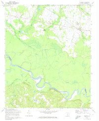 1972 Gadsden1974 Print · USGSRichland and Calhoun counties are defined by the winding Congaree River in this early 1970s survey. Genealogists and local historians can locate many rural landmarks including Mt Moriah Ch, Gadsden Sch, and the SOUTHERN railroad line.3 unique versions available
 - 1972 Map of Southwest Columbia, 1975 Print
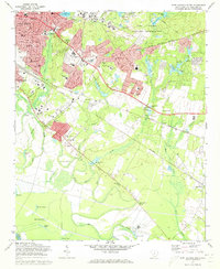
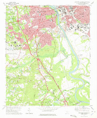 1972 Southwest Columbia1975 Print · USGSGreater Columbia in the early seventies shows a landscape of rapid suburban expansion balanced against the industrial Congaree riverfront. Researchers can trace the mid-century layout of the Columbia Metropolitan Airport, the Columbia Speedway, and local landmarks like Mt Pisgah Ch.2 unique versions available
 - 1972 Map of Gaston, 1975 Print
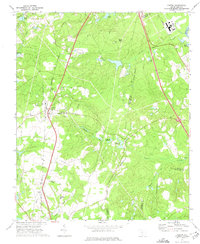 1972 Gaston1975 Print · USGSThe rural midlands of South Carolina are captured here in the early seventies as the local economy shifted from traditional millponds to modern infrastructure. Genealogists can locate family landmarks like Sandy Run Academy, Travis Academy, and Little Zion Ch along the Seaboard Coast Line corridor.2 unique versions available
End of results
Showing maps 1-6 of 6
Top cities of Calhoun County
Frequently asked questions
- What are the different types of historical maps available for Calhoun County?
- What is the oldest map of Calhoun County?
- Where can I purchase historical maps of Calhoun County for my home or office?
- Where can I download high-res historical maps of Calhoun County?
- Are there historical topographic maps available for Calhoun County?
- Is there historical aerial imagery available for Calhoun County?
- Where are historical maps of Calhoun County sourced from?