1940s Maps of Calhoun County, South Carolina
Explore 8 historic maps of Calhoun County from the 1940s. These maps offer a rare glimpse into what life looked like during the 1940s — showing old roads, neighborhoods, homes, and landmarks that have changed or disappeared over time.
Whether you're researching your family's past, planning a metal detecting trip, or studying how Calhoun County's landscape evolved across the 1940s, these high-resolution maps are a powerful tool for exploring the history of this region.
- Focus on a specific era: All maps on this page are from the 1940s, giving you a focused view of this time period.
- See what’s changed: Compare century-old streets, trails, and buildings to today's modern landscape using overlays and satellite layers.
- Research with precision: Use these maps for genealogy, historical research, land use analysis, or educational projects.
- View, download, or print: Maps are fully viewable online in high resolution, and can be downloaded or printed for your own records.
Start exploring Calhoun County's history through authentic maps from the 1940s. This is your window into the past.
Calhoun County, SC maps
(8)- 1943 Map of Bowman
 1943 Bowman1943 Print · USGSThe rural Lowcountry of the 1940s is captured here in detail, showcasing the agrarian life of Orangeburg County. Genealogists can trace family footprints through numerous local landmarks like Bochette Cem, Dawkins Chapel, and Stephens Sch.
 - 1943 Map of Orangeburg
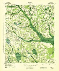
 1943 Orangeburg1943 Print · USGSCoastal plain settlements and river forks define the South Carolina lowcountry during the early war years. Genealogists can trace family landmarks like Bochette Cem, Hunters Chapel Zion Ch, and unique sites like the Indian Field Camp Grounds.
 - 1943 Map of Eastover, 1953 Print
 1943 Eastover1953 Print · USGSIn the early 1940s, the rural landscapes of Richland and Sumter counties centered on the river junctions and thriving rail lines. Genealogists can trace family landmarks like Good Hope Ch and Bethel Sch or follow the path of the Kings Highway.
 - 1944 Map of Edmund, 1966 Print
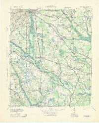
 1944 Edmund1966 Print · USGSLexington County and the southern fringes of Columbia are shown in detail during the final years of World War II. Researchers can locate family landmarks like Saxe Gotha Sch, the Columbia Air Base, and Huckabaas Millpond.
 - 1946 Map of Elloree
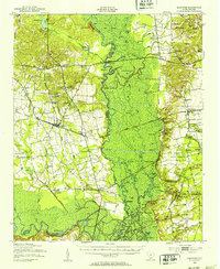
 1946 Elloree1946 Print · USGSCoastal plain settlements and rising reservoir waters define this mid-1940s landscape in the Santee River basin. Genealogists and historians can trace the foundations of Langsynt Plantation, locate numerous rural churches like Mizpah Ch, or study the rail corridor through Lone Star.2 unique versions available
 - 1946 Map of Woodford
 1946 Woodford1946 Print · USGSThe mid-century rural landscape of Orangeburg and Lexington Counties is captured here as the Edisto River basin supported a network of small mill towns. Genealogists can trace family connections to numerous local landmarks like Kings Grove Ch, Darian Sch, and Pooles Millpond.3 unique versions available
 - 1946 Map of St. Matthews
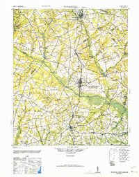
 1946 St. Matthews1946 Print · USGSSouth Carolina’s agricultural heartland is documented here in the mid-forties as the rail lines connected rural crossroads to the county seat. Genealogists can trace family landmarks and community centers like Bethlehem Church, Hammond Crossroads, and the historic Old Ninety-Six Road.2 unique versions available
 - 1948 Map of Hopkins
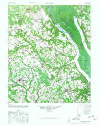
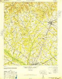
 1948 Hopkins1948 Print · USGSRichland and Calhoun counties are captured here just after the war, showing the expansion of federal military sites into the rural South Carolina landscape. Genealogists can locate family-named landmarks like Coughmans Pond and dozens of country schools including Lower Richland High Sch and Hopkins Sch.3 unique versions available
End of results
Showing maps 1-8 of 8
Top cities of Calhoun County
Frequently asked questions
- What are the different types of historical maps available for Calhoun County?
- What is the oldest map of Calhoun County?
- Where can I purchase historical maps of Calhoun County for my home or office?
- Where can I download high-res historical maps of Calhoun County?
- Are there historical topographic maps available for Calhoun County?
- Is there historical aerial imagery available for Calhoun County?
- Where are historical maps of Calhoun County sourced from?