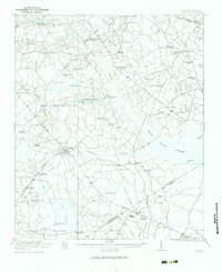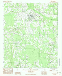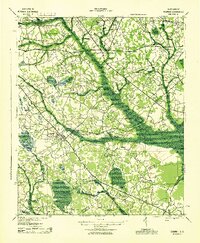
1943 Map of Bowman
USGS Topo · Published 1943About this map
Bowman and its rural hinterlands in Orangeburg and Dorchester counties are defined by a dense network of country schools and churches that served the agricultural community during the early 1940s. The landscape is structured by numerous drainage systems, including Indian Camp Branch and Murray Branch, which separate the various neighborhood clusters. Education was highly localized, with institutions such as Indian Field Sch, Goodbys Sch, and West Middle Sch dotting the terrain. Religious life centered on sites like Andrews Chapel and the Camp Meeting Ground near the southern edge of the survey. The Atlantic Coast Line railroad runs through the northeastern corner, anchoring the settlement of Parler, while the historic Vance Road provides a primary east-west corridor for the region's transport and commerce.
Find a feature on this map
51 named features on this map. Tap any name to fly to it.
Don’t see what you’re looking for? This feature index may not catch every label — zoom into the map to look around manually.
Map Details
Editions of this 1943 Bowman Map
This is the sole edition of this map. No revisions or reprints were ever made.
Historical Maps of Bowman Through Time
9 maps found