1970s Maps of Blacksburg, South Carolina
Explore 3 historic maps of Blacksburg from the 1970s. These maps offer a rare glimpse into what life looked like during the 1970s — showing old roads, neighborhoods, homes, and landmarks that have changed or disappeared over time.
Whether you're researching your family's past, planning a metal detecting trip, or studying how Blacksburg's landscape evolved across the 1970s, these high-resolution maps are a powerful tool for exploring the history of this region.
- Focus on a specific era: All maps on this page are from the 1970s, giving you a focused view of this time period.
- See what’s changed: Compare century-old streets, trails, and buildings to today's modern landscape using overlays and satellite layers.
- Research with precision: Use these maps for genealogy, historical research, land use analysis, or educational projects.
- View, download, or print: Maps are fully viewable online in high resolution, and can be downloaded or printed for your own records.
Start exploring Blacksburg's history through authentic maps from the 1970s. This is your window into the past.
Blacksburg, SC maps
(3)- 1971 Map of Blacksburg South, 1974 Print
 1971 Blacksburg South1974 Print · USGSCherokee County at the start of the seventies reveals a landscape of river-dependent industry and scattered rural communities. Genealogists can trace family roots through sites like Old McKowns Mtn Church, Cashion Crossroads, and Mountain View Cemetery.
 - 1971 Map of Blacksburg North, 1974 Print
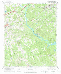
 1971 Blacksburg North1974 Print · USGSThe Carolina borderlands come into focus in the early 1970s as the river-driven industry of the Piedmont matures. Researchers can trace family-named landmarks and rural centers like Patterson Springs, Old Falls Chapel, and the Stice Shoals Dam.
 - 1976 Map of Blacksburg North, 1978 Print
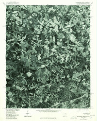 1976 Blacksburg North1978 Print · USGSThe borderlands of the Carolinas are captured in this mid-seventies aerial survey, showing the landscape as it transitioned toward modern development. Researchers can trace land use patterns around Blacksburg and locate historical structures near Earl and Patterson Springs.
End of results
Showing maps 1-3 of 3
Top cities near Blacksburg
- Gastonia historical maps
- Shelby historical maps
- Gaffney historical maps
- Kings Mountain historical maps
- Bessemer City historical maps
- Boiling Springs historical maps
See more
Top neighborhoods of Blacksburg
Frequently asked questions
- What are the different types of historical maps available for Blacksburg?
- What is the oldest map of Blacksburg?
- Where can I purchase historical maps of Blacksburg for my home or office?
- Where can I download high-res historical maps of Blacksburg?
- Are there historical topographic maps available for Blacksburg?
- Is there historical aerial imagery available for Blacksburg?
- Where are historical maps of Blacksburg sourced from?