1980s Maps of Dorchester County, South Carolina
Explore 10 historic maps of Dorchester County from the 1980s. These maps offer a rare glimpse into what life looked like during the 1980s — showing old roads, neighborhoods, homes, and landmarks that have changed or disappeared over time.
Whether you're researching your family's past, planning a metal detecting trip, or studying how Dorchester County's landscape evolved across the 1980s, these high-resolution maps are a powerful tool for exploring the history of this region.
- Focus on a specific era: All maps on this page are from the 1980s, giving you a focused view of this time period.
- See what’s changed: Compare century-old streets, trails, and buildings to today's modern landscape using overlays and satellite layers.
- Research with precision: Use these maps for genealogy, historical research, land use analysis, or educational projects.
- View, download, or print: Maps are fully viewable online in high resolution, and can be downloaded or printed for your own records.
Start exploring Dorchester County's history through authentic maps from the 1980s. This is your window into the past.
Dorchester County, SC maps
(10)- 1980 Map of Cottageville
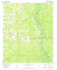 1980 Cottageville1980 Print · USGSThe Lowcountry landscape of the 1970s is captured here as the Edisto River winds past historical landings and the settlement of Cottageville. Researchers can trace family history through numerous sites like Church Hill Cem, Macedonia Ch, and the Sullivans Ferry crossing.2 unique versions available
 - 1982 Map of Branchville South, 1983 Print
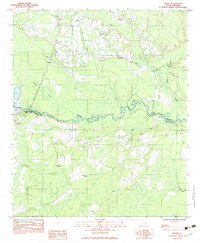
 1982 Branchville South1983 Print · USGSThe Edisto River lowlands were still defined by traditional river crossings and rural church communities in the early 1980s. Researchers can locate family landmarks like Mc Alhany Cem and the river-crossing at Sandy Island Bridge near Branchville.
 - 1982 Map of St. George SW, 1983 Print
 1982 St. George SW1983 Print · USGSColleton and Dorchester counties are captured here in the early 1980s as the river-and-rail economy defined the landscape. Researchers can trace family roots through numerous sites like Spell Cem, Springtown, and the Seaboard Coast Line Railroad.
 - 1982 Map of Grover, 1983 Print
 1982 Grover1983 Print · USGSDorchester and Colleton counties are captured in the early eighties as the river-bound communities maintained their rural character. Researchers can trace family history through numerous landmarks like Utsey Cem, St Lukes Ch, and the crossing at Stokes Bridge.
 - 1982 Map of Reevesville, 1983 Print
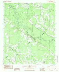
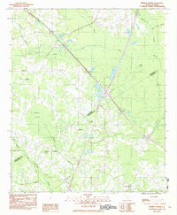
 1982 Reevesville1983 Print · USGSReevesville and the surrounding rural communities of Dorchester County are captured here in the early eighties. Researchers can trace family roots through numerous local landmarks, including Magnolia Cemetery, Sugar Hill, and the tracks of the SOUTHERN railroad.
 - 1982 Map of St. George, 1983 Print
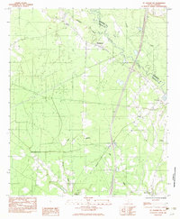
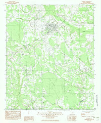
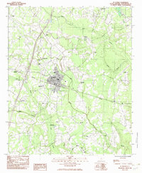 1982 St. George1983 Print · USGSDorchester County's landscape in the early eighties is captured here, centered on the historic rail town of St George. Genealogists can trace the locations of family landmarks like Good Hope Cem, Dukes Cem, and the notable Indian Field Campground.
 - 1982 Map of Wadboo Swamp, 1983 Print
 1982 Wadboo Swamp1983 Print · USGSOrangeburg and Dorchester Counties are shown in the mid-seventies, where a network of lowland swamps and rural congregations define the local landscape. Researchers can trace the proximity of long-standing community sites like Ebenezer Ch and Rosinville to the sprawling Four Hole Swamp.
 - 1982 Map of Bowman, 1983 Print
 1982 Bowman1983 Print · USGSThe rural town of Bowman and its surrounding wetlands are captured here in the mid-1970s. Researchers can trace local heritage through the placement of Rigby Cem, the High Sch, and rural congregations like Mt Tabor Ch and Prospect Ch.
 - 1985 Map of Saint George, 1986 Print
 1985 Saint George1986 Print · USGSThe South Carolina Lowcountry in the mid-eighties shows a landscape defined by the great reservoirs and the meandering Edisto River. Researchers can trace the rail corridors of the Southern Railway and find rural settlements like Harleyville, Smoaks, and Grover.
 - 1986 Map of Walterboro
 1986 Walterboro1986 Print · USGSThe South Carolina Lowcountry in the mid-eighties remains a world of expansive wetlands and historic river crossings. Genealogists and historians can trace the rural communities and landmarks of Colleton and Charleston counties, from the Baptist Church at Adams Run to the coastal reaches of Edisto Beach State Park.
End of results
Showing maps 1-10 of 10
Top cities of Dorchester County
- Summerville historical maps
- Ridgeville historical maps
- Harleyville historical maps
- Reevesville historical maps
Frequently asked questions
- What are the different types of historical maps available for Dorchester County?
- What is the oldest map of Dorchester County?
- Where can I purchase historical maps of Dorchester County for my home or office?
- Where can I download high-res historical maps of Dorchester County?
- Are there historical topographic maps available for Dorchester County?
- Is there historical aerial imagery available for Dorchester County?
- Where are historical maps of Dorchester County sourced from?