Old Maps of Dorchester County, South Carolina for Genealogy
Trace your family roots with 166 historic maps of Dorchester County. These high-res maps reveal old neighborhoods, homesites, landmarks, and streets — helping you uncover where your ancestors lived and how the area evolved over time.
- Explore historic neighborhoods: Identify where your relatives may have lived in the 1800s or 1900s.
- Compare maps over time: Trace the changes in streets, buildings, and landmarks for multi-generational research.
- Perfect for genealogy & ancestry research: Used by family historians and researchers to map out lineage and migration.
These maps are an incredible resource for exploring your personal connection to Dorchester County's past.
Dorchester County, SC maps
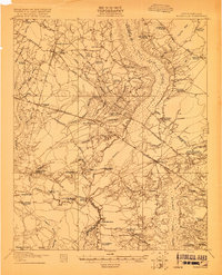
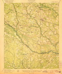
(166)- 1918 Map of Cottageville
 1918 Cottageville1918 Print · USGSThe Lowcountry river basins of Colleton and Dorchester counties are shown here just after the Great War, when the Edisto River was a central geographic divider. Researchers can trace rural life through dozens of named landmarks like Sullivans Church, Metz Store, and Burnt Church Crossroads.3 unique versions available
 - 1919 Map of Ladson
 1919 Ladson1919 Print · USGSThe South Carolina lowcountry is captured here just after the Great War, showing a landscape of riverfront estates and rail-connected settlements. Researchers can trace the grounds of Magnolia Gardens or locate rural centers like Ladson and Otranto.2 unique versions available
 - 1919 Map of Summerville
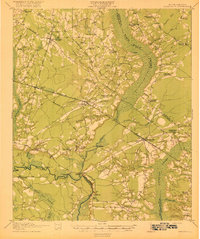
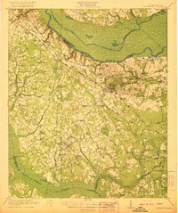
 1919 Summerville1919 Print · USGSSummerville and the surrounding Lowcountry wetlands are captured here just after the Great War, during a period of established rail reliance and rural growth. Genealogists and researchers can trace local landmarks like St Johns Church, the Clemson Coast Express Station, and numerous early school sites including Barrow School.
 - 1919 Map of Ridgeville
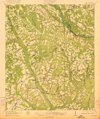
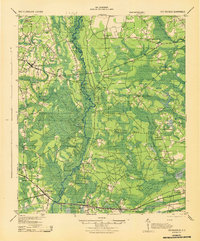
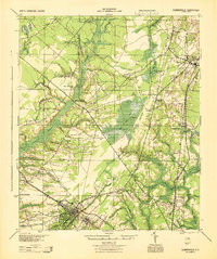
 1919 Ridgeville1919 Print · USGSCoastal South Carolina at the end of the Great War era reveals a landscape of dense swamps and rail-side settlements. Genealogists can trace family roots through numerous local landmarks like Cypress Camp Meeting Grounds, Mudville School, and Limestone Church.
 - 1919 Map of Lodge, 1974 Print
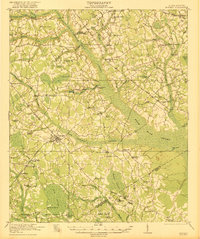
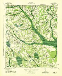
 1919 Lodge1974 Print · USGSCoastal plain life in the early twentieth century is mapped here through its river-reliant settlements and extensive swamp networks. Genealogists can trace family footprints across dozens of local landmarks like Lodge, Smoaks, and Zion Church.
 - 1920 Map of Eutawville
 1920 Eutawville1920 Print · USGSCoastal South Carolina comes to life in the years following the Great War, showing a landscape defined by the Santee River and Four Hole Swamp. Genealogists can trace family roots through numerous local landmarks like Black Creek Church, Unity School, and the settlement at Holly Hill.
 - 1920 Map of Bowman
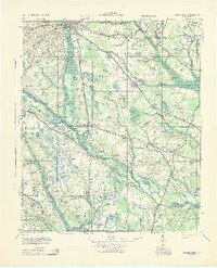
 1920 Bowman1920 Print · USGSIn the early twentieth century, this part of the South Carolina Lowcountry was a landscape of remote settlements and small-scale industry. Genealogists can trace family footprints through numerous community landmarks like Boghette Cem, Livingston Mill, and the Shady Grove Camp Ground.
 - 1920 Map of Ravenels
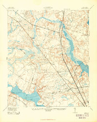
 1920 Ravenels1920 Print · USGSThe Ashley River and its surrounding swamps were the heart of this Lowcountry landscape just after the First World War. Researchers can trace the footprints of Old Dorchester, the operations at Bula Mines, and the unique Tyler Tea Farm.3 unique versions available
 - 1920 Map of Lodge
 1920 Lodge1920 Print · USGSColleton and Bamberg counties at the dawn of the 1920s show a landscape of river-bottom farms and rural junctions. Genealogists can trace the location of early country institutions like Hunters Chapel, Tabernacle School, and the rail crossing at Hampton Branch Junction.
 - 1920 Map of Ridgeville
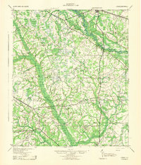
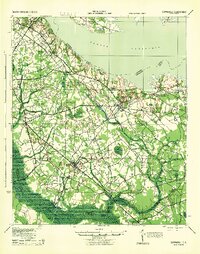
 1920 Ridgeville1920 Print · USGSDorchester County and the surrounding Lowcountry wetlands are captured here just after the Great War, as railroads and swamp crossings defined local life. Trace the old rail lines through Ridgeville and Harleyville or find historic sites like the Two Run Church and Mudville School.3 unique versions available
 - 1920 Map of St. George
 1920 St. George1920 Print · USGSCoastal plain life in the 1920s centered on the Edisto River and the small railroad towns that bridged the area's vast swamps. Researchers can locate numerous vanished country landmarks, from St James Cemetery to the Cattle Creek School and Independence School.
 - 1920 Map of Summerville
 1920 Summerville1920 Print · USGSThe South Carolina Lowcountry at the close of the Great War reveals a landscape of deep cypress basins and burgeoning rail-side towns. Genealogists can locate numerous rural landmarks like Appii Church, Whitesville School, and the Clemson Coast Experiment Station.3 unique versions available
 - 1921 Map of Lodge
 1921 Lodge1921 Print · USGSThe Salkehatchie and Edisto river basins come alive in this early 1920s survey of the South Carolina Lowcountry. Researchers can trace rural genealogy and old rail lines through local landmarks like Hunters Chapel, Smoaks, and the Hampton and Branchville RR.3 unique versions available
 - 1921 Map of Bowman
 1921 Bowman1921 Print · USGSIn the early 1920s, the rural community of Bowman was a bustling intersection of country schools and swamp-fed drainage. Genealogists can trace family footprints through dozens of landmarks like Rochette Cemetery, the Campmeeting Grounds, and Livingston Mill.4 unique versions available
 - 1921 Map of St. George
 1921 St. George1921 Print · USGSThe Edisto River valley in the early 1920s was a landscape of small farming hamlets and vital rail connections. Genealogists can trace family roots through numerous sites like Indian Field Campgrounds, St James Cemetery, and the Heaton School.4 unique versions available
 - 1921 Map of Eutawville
 1921 Eutawville1921 Print · USGSCoastal South Carolina comes to life in this early twentieth-century survey of the Santee River lowlands and the growing railroad towns of the coastal plain. Genealogists can trace the location of community anchors like Gerizim Church, the Eutaw Springs Battle Monument, and Nelsons Ferry.3 unique versions available
 - 1943 Map of Cottageville
 1943 Cottageville1943 Print · USGSThe South Carolina Lowcountry in the early forties reveals a landscape of river landings and remote crossroads between the Edisto and the swamps. Genealogists can trace family landmarks and school sites like Rehoboth Sch or locate the old Sullivans Ferry crossing.
 - 1943 Map of Bowman
 1943 Bowman1943 Print · USGSThe rural Lowcountry of the 1940s is captured here in detail, showcasing the agrarian life of Orangeburg County. Genealogists can trace family footprints through numerous local landmarks like Bochette Cem, Dawkins Chapel, and Stephens Sch.
 - 1943 Map of Lodge
 1943 Lodge1943 Print · USGSThe South Carolina Lowcountry is captured here in the early 1940s at the junction of four counties. Genealogists can trace family roots through numerous rural landmarks like H & B Junction, Hunters Chapel, and the Little Swamp Sch.
 - 1943 Map of Orangeburg
 1943 Orangeburg1943 Print · USGSCoastal plain settlements and river forks define the South Carolina lowcountry during the early war years. Genealogists can trace family landmarks like Bochette Cem, Hunters Chapel Zion Ch, and unique sites like the Indian Field Camp Grounds.
 - 1943 Map of Ladson
 1943 Ladson1943 Print · USGSBerkeley and Dorchester counties come into focus during the early war years, revealing a landscape of historic river estates and new military infrastructure. Genealogists and historians can trace family-named sites like Windsor Hill and Ararat, or locate local landmarks like Goose Creek Ch and Magnolia Gardens.2 unique versions available
 - 1943 Map of Ridgeville
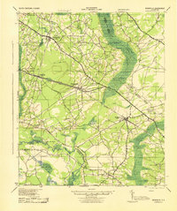 1943 Ridgeville1943 Print · USGSDorchester County and its neighbors are shown here during the early years of the Second World War as the rail-and-timber landscape remained deeply rural. Genealogists can trace family landmarks and rural education hubs like Mudville Sch, Rehoboth Sch, and the Cypress Swamp Camp Meeting Grounds.
 - 1943 Map of Eutawville, 1944 Print
 1943 Eutawville1944 Print · USGSCoastal South Carolina during the mid-forties shows a landscape of historic battlefields and newly formed reservoirs. Genealogists and historians can trace family church and school sites like Gerizim Ch and Stutz Sch or locate the Eutaw Battle Monument.
 - 1944 Map of Ravenels
 1944 Ravenels1944 Print · USGSCoastal South Carolina just before the war's end reveals a landscape of tidal rivers and deep-rooted settlements. Trace the footprints of the past at Old Dorchester, locate family homesteads near Poppenheim Crossing, or find long-vanished industry at the Bula Mines.
 - 1944 Map of Summerville
 1944 Summerville1944 Print · USGSThe South Carolina lowcountry near the end of World War II is documented here, showing the rural landscapes of Dorchester and Berkeley counties. Genealogists can trace family roots through numerous local landmarks like Black Tom Sch, St Johns Ch, and Lincolnville.
Showing maps 1-25 of 166
Top cities of Dorchester County
- Summerville historical maps
- Ridgeville historical maps
- Harleyville historical maps
- Reevesville historical maps
Frequently asked questions
- What are the different types of historical maps available for Dorchester County?
- What is the oldest map of Dorchester County?
- Where can I purchase historical maps of Dorchester County for my home or office?
- Where can I download high-res historical maps of Dorchester County?
- Are there historical topographic maps available for Dorchester County?
- Is there historical aerial imagery available for Dorchester County?
- Where are historical maps of Dorchester County sourced from?