1970s Maps of Fairfield County, South Carolina
Explore 8 historic maps of Fairfield County from the 1970s. These maps offer a rare glimpse into what life looked like during the 1970s — showing old roads, neighborhoods, homes, and landmarks that have changed or disappeared over time.
Whether you're researching your family's past, planning a metal detecting trip, or studying how Fairfield County's landscape evolved across the 1970s, these high-resolution maps are a powerful tool for exploring the history of this region.
- Focus on a specific era: All maps on this page are from the 1970s, giving you a focused view of this time period.
- See what’s changed: Compare century-old streets, trails, and buildings to today's modern landscape using overlays and satellite layers.
- Research with precision: Use these maps for genealogy, historical research, land use analysis, or educational projects.
- View, download, or print: Maps are fully viewable online in high resolution, and can be downloaded or printed for your own records.
Start exploring Fairfield County's history through authentic maps from the 1970s. This is your window into the past.
Fairfield County, SC maps
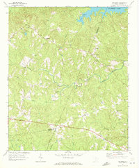
(8)- 1971 Map of Liberty Hill, 1972 Print
 1971 Liberty Hill1972 Print · USGSThe Kershaw County backcountry meets the expanding shoreline of Watere Lake in the early seventies. Genealogists can trace rural life through landmarks like Liberty Hill, Oak Spring Ch, and the New Grove Cem along the river's winding inlets.
 - 1971 Map of Flint Hill, 1972 Print
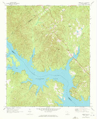
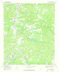
 1971 Flint Hill1972 Print · USGSFairfield County in the early seventies centers on the expansive waters of Wateree Lake and its rural backcountry. Genealogists and local historians can trace small communities like Flint Hill and find landmarks such as Mt Zion Ch and the local Landing Strip.2 unique versions available
 - 1971 Map of Ridgeway, 1972 Print
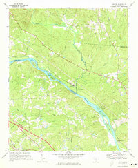
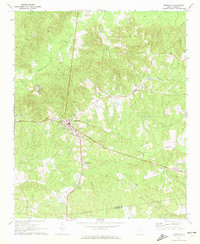 1971 Ridgeway1972 Print · USGSThe town of Ridgeway and its surrounding countryside are captured in the early 1970s as a vital railroad and agricultural crossroads. Genealogists and historians can trace local landmarks like Aimwell Cem, St Stephens Ch, and the outlying Oak Grove Sch.
 - 1971 Map of Longtown, 1972 Print
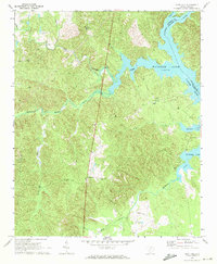
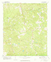
 1971 Longtown1972 Print · USGSFairfield County's rural backcountry and the northern reaches of the Wateree reservoir are captured here during the early seventies. Genealogists and local researchers can locate numerous family-linked landmarks such as Longtown Cem, Rock Hill Ch, and the intersection at Warren Crossroads.
 - 1971 Map of Blythewood, 1973 Print
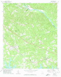
 1971 Blythewood1973 Print · USGSBlythewood and the rural stretches of Richland County are shown in the early seventies as small communities began to grow along the Southern railroad. Researchers can trace the footprints of Hanbury Jr High Sch, Bethel Ch, and the old sandpits.2 unique versions available
 - 1971 Map of Richtex, 1973 Print
 1971 Richtex1973 Print · USGSThe river and rail corridors of Richland and Fairfield counties come alive in the early seventies. Genealogists can trace family landmarks like Gibson Cem and Robinson Cem or find old congregations at Zion Pilgrim Ch and Shady Grove Ch.3 unique versions available
 - 1971 Map of Irmo NE, 1973 Print
 1971 Irmo NE1973 Print · USGSRichland and Fairfield counties are shown in the early seventies, a landscape where rural church life and family cemeteries anchor the community. Researchers can trace dozens of local landmarks, including the Taylor Chapel Cem, Beulah Ch, and Camp Dixon.3 unique versions available
 - 1971 Map of Chapin, 1974 Print
 1971 Chapin1974 Print · USGSChapin and the northern shores of Lake Murray are shown here in the early 1970s as the area balanced its rural rail history with new shoreline growth. Genealogists can locate family landmarks like Eargle Cem, St Jacobs Ch, and the old settlement at White Rock.3 unique versions available
End of results
Showing maps 1-8 of 8
Top cities of Fairfield County
Frequently asked questions
- What are the different types of historical maps available for Fairfield County?
- What is the oldest map of Fairfield County?
- Where can I purchase historical maps of Fairfield County for my home or office?
- Where can I download high-res historical maps of Fairfield County?
- Are there historical topographic maps available for Fairfield County?
- Is there historical aerial imagery available for Fairfield County?
- Where are historical maps of Fairfield County sourced from?