1970s Maps of Florence County, South Carolina
Explore 4 historic maps of Florence County from the 1970s. These maps offer a rare glimpse into what life looked like during the 1970s — showing old roads, neighborhoods, homes, and landmarks that have changed or disappeared over time.
Whether you're researching your family's past, planning a metal detecting trip, or studying how Florence County's landscape evolved across the 1970s, these high-resolution maps are a powerful tool for exploring the history of this region.
- Focus on a specific era: All maps on this page are from the 1970s, giving you a focused view of this time period.
- See what’s changed: Compare century-old streets, trails, and buildings to today's modern landscape using overlays and satellite layers.
- Research with precision: Use these maps for genealogy, historical research, land use analysis, or educational projects.
- View, download, or print: Maps are fully viewable online in high resolution, and can be downloaded or printed for your own records.
Start exploring Florence County's history through authentic maps from the 1970s. This is your window into the past.
Florence County, SC maps
(4)- 1972 Map of Oak Grove, 1975 Print
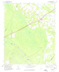 1972 Oak Grove1975 Print · USGSDillon County at the start of the 1970s is a landscape of expansive wetlands and river-bottom timber defined by the winding Pee Dee River. Researchers can trace old transportation corridors along the Old RR Grade and locate rural landmarks like Bethesda Ch or Haselden Cem.2 unique versions available
 - 1972 Map of Witherspoon Island, 1976 Print
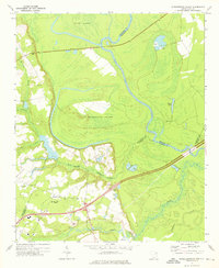 1972 Witherspoon Island1976 Print · USGSThe Pee Dee River lowlands come to life in the early 1970s, showcasing the intricate water systems surrounding Witherspoon Island. Researchers can trace local family landmarks near Blacks, including Century Ch and Cem, or locate industrial sites like the Fish Hatchery.2 unique versions available
 - 1973 Map of Lynchburg, 1975 Print
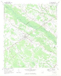 1973 Lynchburg1975 Print · USGSLynchburg and the surrounding rural communities thrive along the banks of the Lynches River in the early seventies. Genealogists and historians can trace family roots at St Matthews Ch, locate the Hawkins Cem, or follow the path of the Old Stagecoach Road.
 - 1974 Map of Georgetown, 1978 Print
 1974 Georgetown1978 Print · USGSThe Carolina coast and Pee Dee region are shown here in the mid-seventies, just as the Grand Strand was maturing into a premier destination. Researchers can trace the inland rail corridors of the Seaboard Coast Line Railroad or explore the coastal reaches of the Cape Romain National Wildlife Refuge and Myrtle Beach State Park.2 unique versions available
End of results
Showing maps 1-4 of 4
Top cities of Florence County
- Florence historical maps
- Lake City historical maps
- Timmonsville historical maps
- Johnsonville historical maps
- Pamplico historical maps
- Scranton historical maps
See more
Frequently asked questions
- What are the different types of historical maps available for Florence County?
- What is the oldest map of Florence County?
- Where can I purchase historical maps of Florence County for my home or office?
- Where can I download high-res historical maps of Florence County?
- Are there historical topographic maps available for Florence County?
- Is there historical aerial imagery available for Florence County?
- Where are historical maps of Florence County sourced from?