1990s Maps of Florence County, South Carolina
Explore 10 historic maps of Florence County from the 1990s. These maps offer a rare glimpse into what life looked like during the 1990s — showing old roads, neighborhoods, homes, and landmarks that have changed or disappeared over time.
Whether you're researching your family's past, planning a metal detecting trip, or studying how Florence County's landscape evolved across the 1990s, these high-resolution maps are a powerful tool for exploring the history of this region.
- Focus on a specific era: All maps on this page are from the 1990s, giving you a focused view of this time period.
- See what’s changed: Compare century-old streets, trails, and buildings to today's modern landscape using overlays and satellite layers.
- Research with precision: Use these maps for genealogy, historical research, land use analysis, or educational projects.
- View, download, or print: Maps are fully viewable online in high resolution, and can be downloaded or printed for your own records.
Start exploring Florence County's history through authentic maps from the 1990s. This is your window into the past.
Florence County, SC maps
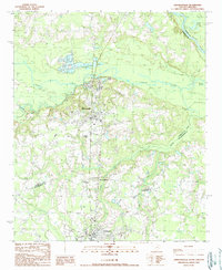
(10)- 1990 Map of Olanta
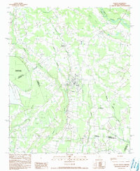 1990 Olanta1990 Print · USGSThe South Carolina coastal plain in the late twentieth century is captured here as a landscape of unique Carolina Bays and rural crossroads. Researchers can trace landownership patterns near Olanta or explore the preserved wetlands of Woods Bay State Park and Fuller Bay.
 - 1990 Map of Scranton
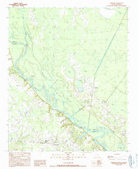
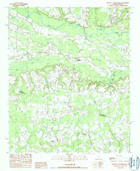
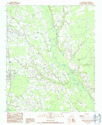 1990 Scranton1990 Print · USGSFlorence County life in the early nineties is centered on the railroad corridor and the wetlands of the Lynches River. Genealogists and local historians can trace family roots through several Cem locations and the settlements of Scranton, Coward, and Friendfield.
 - 1990 Map of Pamplico South
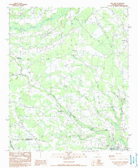
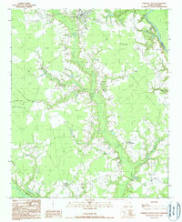 1990 Pamplico South1990 Print · USGSThe Pee Dee region of Florence County is shown in the mid-1980s, bordered by the winding Great Pee Dee River and Lynches River. Researchers can locate rural community hubs like Butler Crossroads, Hannah, and the Mt Zion Ch area.
 - 1990 Map of Lake City East
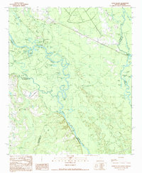
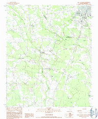
 1990 Lake City East1990 Print · USGSCoastal plain wetlands and rural crossroads define the landscape around Lake City in the 1980s. Researchers can trace local drainage and land use along the vast Lake Swamp or locate family roots near Lee Crossroads and several rural cemeteries.
 - 1990 Map of Snow Island
 1990 Snow Island1990 Print · USGSThe river-bound territory of Marion and Florence counties is captured in the late twentieth century, showing a landscape of dense swamps and shifting oxbows. Local historians can trace the geography of Snow Island, the reaches of Brittons Neck, and the location of Sampson Landing.
 - 1990 Map of Johnsonville
 1990 Johnsonville1990 Print · USGSCoastal plain river systems and rural crossroads define this South Carolina landscape during the early 1990s. Researchers can trace the development of Johnsonville and Hemingway or locate family sites near Ard Crossroads and Crooks Crossroads.
 - 1990 Map of Gresham
 1990 Gresham1990 Print · USGSMarion and Florence counties met along the river in the 1990s, defined by the winding course of the Great Pee Dee River. Genealogists and historians can trace old community hubs like Gresham and Kingsburg or locate riverfront sites like Catfish Landing.
 - 1990 Map of Mill Bay
 1990 Mill Bay1990 Print · USGSThe Florence and Williamsburg county line comes alive in the 1990s as a landscape of agricultural settlements and distinctive Carolina Bays. Genealogists and local historians can trace family locations near Lake City, Byrds Crossroads, and along the banks of Lynches River.
 - 1990 Map of Lake City West
 1990 Lake City West1990 Print · USGSCoastal plain settlements in Florence and Williamsburg counties appear in detail during the early 1990s. Genealogists and researchers can trace rural hubs like Hogeye Crossroads, the community of Cades, and family-named landmarks like Smiths Bay.
 - 1990 Map of Prospect Crossroads
 1990 Prospect Crossroads1990 Print · USGSThe rural borderlands of Florence and Williamsburg counties come into focus in the 1980s, centered on the Lynches River corridor. Genealogists and local historians can trace family locations near Prospect Crossroads, Midway Crossroads, and the small settlement of Leo.
End of results
Showing maps 1-10 of 10
Top cities of Florence County
- Florence historical maps
- Lake City historical maps
- Timmonsville historical maps
- Johnsonville historical maps
- Pamplico historical maps
- Scranton historical maps
See more
Frequently asked questions
- What are the different types of historical maps available for Florence County?
- What is the oldest map of Florence County?
- Where can I purchase historical maps of Florence County for my home or office?
- Where can I download high-res historical maps of Florence County?
- Are there historical topographic maps available for Florence County?
- Is there historical aerial imagery available for Florence County?
- Where are historical maps of Florence County sourced from?