1940s Maps of Augusta Fields, South Carolina
Explore 1 historic maps of Augusta Fields from the 1940s. These maps offer a rare glimpse into what life looked like during the 1940s — showing old roads, neighborhoods, homes, and landmarks that have changed or disappeared over time.
Whether you're researching your family's past, planning a metal detecting trip, or studying how Augusta Fields's landscape evolved across the 1940s, these high-resolution maps are a powerful tool for exploring the history of this region.
- Focus on a specific era: All maps on this page are from the 1940s, giving you a focused view of this time period.
- See what’s changed: Compare century-old streets, trails, and buildings to today's modern landscape using overlays and satellite layers.
- Research with precision: Use these maps for genealogy, historical research, land use analysis, or educational projects.
- View, download, or print: Maps are fully viewable online in high resolution, and can be downloaded or printed for your own records.
Start exploring Augusta Fields's history through authentic maps from the 1940s. This is your window into the past.
Augusta Fields, SC maps
(1)- 1949 Map of Greenwood
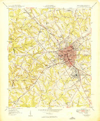 1949 Greenwood1949 Print · USGSGreenwood flourished as a major rail and textile crossroads in the late forties, its landscape defined by industrial villages and extensive trackage. Genealogists and historians can trace neighborhood roots through Lander College, the Connie Maxwell Childrens Home, and several mill villages.2 unique versions available
End of results
Showing maps 1-1 of 1
Top cities near Augusta Fields
- Greenwood historical maps
- Abbeville historical maps
- McCormick historical maps
- Ninety Six historical maps
- Cross Hill historical maps
- Donalds historical maps
See more
Frequently asked questions
- What are the different types of historical maps available for Augusta Fields?
- What is the oldest map of Augusta Fields?
- Where can I purchase historical maps of Augusta Fields for my home or office?
- Where can I download high-res historical maps of Augusta Fields?
- Are there historical topographic maps available for Augusta Fields?
- Is there historical aerial imagery available for Augusta Fields?
- Where are historical maps of Augusta Fields sourced from?