1900s (20th Century) Maps of Jasper County, South Carolina
Explore 59 historic maps of Jasper County from the 1900s (20th Century). These maps offer a rare glimpse into what life looked like during the 1900s — showing old roads, neighborhoods, homes, and landmarks that have changed or disappeared over time.
Whether you're researching your family's past, planning a metal detecting trip, or studying how Jasper County's landscape evolved across the 1900s, these high-resolution maps are a powerful tool for exploring the history of this region.
- Focus on a specific era: All maps on this page are from the 1900s, giving you a focused view of this time period.
- See what’s changed: Compare century-old streets, trails, and buildings to today's modern landscape using overlays and satellite layers.
- Research with precision: Use these maps for genealogy, historical research, land use analysis, or educational projects.
- View, download, or print: Maps are fully viewable online in high resolution, and can be downloaded or printed for your own records.
Start exploring Jasper County's history through authentic maps from the 1900s. This is your window into the past.
Jasper County, SC maps
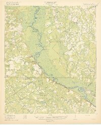
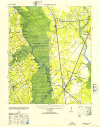
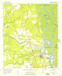
(59)- 1918 Map of Varnville
 1918 Varnville1918 Print · USGSCoastal South Carolina is depicted just after the Great War, showing a network of rail-dependent towns and timber operations. Genealogists can trace family roots through numerous local landmarks like Prince William Church, Hampton, and Harrison Sawmill.4 unique versions available
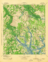
 - 1918 Map of Yemassee
 1918 Yemassee1918 Print · USGSCoastal South Carolina at the end of the Great War reveals a landscape of tidal rivers and emerging rail junctions. Genealogists can trace family locations across Grahams Neck or near historic sites like Pocotaligo, Sheldon, and the logging camps around Gilmania.4 unique versions available
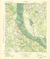
 - 1919 Map of Pineland
 1919 Pineland1919 Print · USGSThe Lowcountry landscape of Jasper and Hampton counties is captured here at the end of the post-war era, showing a transition between rail-centered towns and timber-rich wetlands. Genealogists can locate family ties at Highsmith's Sawmill, Good Hope Church, and the Pineland Club.3 unique versions available
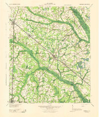
 - 1919 Map of Shirley
 1919 Shirley1919 Print · USGSThe Savannah River borderlands in the years following the Great War reveal a landscape of active river landings, logging railroads, and tight-knit rural communities. You can trace early 20th-century family roots at Heavenly Rest Ch, Cypressvale School, and the busy Hudsons Ferry Landing.3 unique versions available
 - 1920 Map of Hardeeville
 1920 Hardeeville1920 Print · USGSThe Savannah River floodplain in the years following the Great War reveals a world of river landings and emerging rail towns. Genealogists and historians can trace the transition from water to rail through features like Becks Ferry, Hardeeville, and the Indian Mound.
 - 1920 Map of Okatie
 1920 Okatie1920 Print · USGSThe South Carolina Lowcountry is captured here in the years following the Great War, showing a landscape defined by tidal rivers and strategic rail lines. Trace family roots and historical sites through Honey Hill Civil War Entrenchment, Grahamville, and Cherry Point Landing.
 - 1920 Map of Hilton Head
 1920 Hilton Head1920 Print · USGSCoastal Beaufort County appears here as it was just after the Great War, before the bridges and modern development arrived. Genealogists and maritime historians can trace the early settlement of Hilton Head and locate landmarks like the L.H. and Broad Creek.
 - 1920 Map of Bluffton
 1920 Bluffton1920 Print · USGSThe Georgia and South Carolina coastlines meet here in the early twentieth century, showing a world defined by tidal rivers and island outposts. Researchers can trace historic maritime landmarks like Ft. Pulaski, the Long Island Ferry, and family settlements at Spanish Wells or Hickory Bluff.
 - 1942 Map of Savannah
 1942 Savannah1942 Print · USGSCoastal Georgia and the South Carolina borderlands come alive in this wartime survey of the Savannah riverfront. Genealogists and historians can trace industrial housing at Port Wentworth Colored Village, river landmarks like Fort Jackson, and the footprint of the Ogeechee Canal.
 - 1942 Map of Okatie
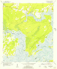
 1942 Okatie1942 Print · USGSCoastal South Carolina at the height of the Second World War shows a landscape of tidal marshes and strategic river landings. Genealogists and historians can trace family locations through named sites like Grahamville, Old House, and the Civil War Entrenchment north of Ridgeland.
 - 1943 Map of Pineland
 1943 Pineland1943 Print · USGSCoastal South Carolina settlements between Hampton and Jasper counties are captured here in the early 1940s. Genealogists can trace family footprints through numerous rural landmarks like Highsmith Sawmill, Pineland Club, and Nixville Sch.2 unique versions available
 - 1943 Map of Hardeeville
 1943 Hardeeville1943 Print · USGSCoastal South Carolina and Georgia meet along the river in the 1940s, showing a landscape shaped by tidewater swamps and early rail corridors. Researchers can trace historic river access at Becks Ferry or locate the Indian Mound near Purrysburg.
 - 1943 Map of Yemassee
 1943 Yemassee1943 Print · USGSThe South Carolina Lowcountry in the early 1940s is defined by its massive tidal rivers and the vital rail junctions at Yemassee. Genealogists and historians can trace old community lines near McPhersonville, Mt Nevo Ch, and the coastal reaches of Seabrook.3 unique versions available
 - 1943 Map of Shirley
 1943 Shirley1943 Print · USGSThe Savannah River valley during the early 1940s reveals a landscape of river landings and rail-side settlements. Genealogists can trace family roots through sites like Heavenly Rest Ch, Mizpah Sch, and the riverside Hudson Ferry Landing.
 - 1944 Map of Varnville
 1944 Varnville1944 Print · USGSHampton County was a bustling corridor of rail lines and rural community centers in the mid-1940s. Genealogists can trace family footprints through numerous local landmarks like Rock Hill Ch, Millville Sch, and the junction at Fairfax.
 - 1945 Map of Bluffton
 1945 Bluffton1945 Print · USGSThe Carolina Lowcountry and Georgia's sea islands appear here in the mid-forties, before modern bridges transformed the coast. Trace the early footprints of Bluffton and Spanish Wells, or locate maritime landmarks like Buckingham Ferry and the Oyster Packing Plant.
 - 1945 Map of Hilton Head
 1945 Hilton Head1945 Print · USGSCoastal South Carolina remains largely rural in the mid-1940s, showing the island long before its modern resort era. Genealogists can trace early community hubs like First Africian Ch, Oak Grove Ch, and the small settlement of Hilton Head.
 - 1947 Map of Savannah
 1947 Savannah1947 Print · USGSCoastal Georgia and South Carolina are captured here in the mid-forties, showing the rail-and-river networks of the Lowcountry. Genealogists and researchers can trace old crossroads and river towns from Statesboro to Beaufort, alongside military sites like Camp Stewart and Parris Island.
 - 1948 Map of Savannah
 1948 Savannah1948 Print · USGSThe Georgia and South Carolina Lowcountry comes alive in this post-war survey of the coast and its river-fed hinterlands. Genealogists and historians can trace rail lines like the Central of Georgia RR and find established settlements such as Isle of Hope and Sylvania.
 - 1953 Map of Hardeeville
 1953 Hardeeville1953 Print · USGSThe riverfront and rail corridors of the South Carolina lowcountry are frozen in time just after the war. Researchers can trace the timber industry through sites like Ebenezer Log, locate the old Okatie Club, or find the Indian Mound near Purrysburg.
 - 1955 Map of Pritchardville, 1956 Print
 1955 Pritchardville1956 Print · USGSThe Beaufort and Jasper County Lowcountry comes alive in this mid-fifties survey of the tidal rivers and marshes before modern development. Genealogists can trace family landmarks like St Matthews Ch, Moreland Cem, and the many Abandoned Rice Fields lining the New River.4 unique versions available
 - 1955 Map of Savannah Beach North, 1956 Print
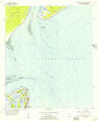 1955 Savannah Beach North1956 Print · USGSThe coastal border of South Carolina and Georgia comes alive in the mid-1950s, detailing the shifting sands and maritime defenses of the Atlantic coast. Researchers can trace the military grounds of Fort Screven or locate the historic Tybee Lighthouse and the small Cem on Tybee Island.3 unique versions available
 - 1955 Map of Fort Pulaski, 1957 Print
 1955 Fort Pulaski1957 Print · USGSCoastal South Carolina and Georgia meet at the mouth of the Savannah River in the mid-fifties, where salt marshes and tidal islands define the border. Researchers can trace historic family sites on Daufuskie Island like Mary Field Cem or locate the Lighthouse (Abandoned) near Fort Pulaski.2 unique versions available
 - 1955 Map of Port Wentworth, 1957 Print
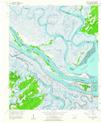
 1955 Port Wentworth1957 Print · USGSCoastal Georgia at the mid-century reveals a complex landscape of river commerce and expanding rail networks north of Savannah. Genealogists and historians can trace family-named sites like Meinhard, Cherokee Hill Cem, and the old Goshen Ch as they appeared before modern development.2 unique versions available
 - 1955 Map of Limehouse, 1957 Print
 1955 Limehouse1957 Print · USGSJasper County and the Savannah River marshes are captured here in the mid-fifties, showing a landscape of coastal wetlands and rural hamlets. Genealogists can locate family landmarks like Williams Cem and Allen Cem, or trace the rail routes of the Atlantic Coast Line.2 unique versions available
Showing maps 1-25 of 59
Top cities of Jasper County
Frequently asked questions
- What are the different types of historical maps available for Jasper County?
- What is the oldest map of Jasper County?
- Where can I purchase historical maps of Jasper County for my home or office?
- Where can I download high-res historical maps of Jasper County?
- Are there historical topographic maps available for Jasper County?
- Is there historical aerial imagery available for Jasper County?
- Where are historical maps of Jasper County sourced from?