1950s Maps of Jasper County, South Carolina
Explore 10 historic maps of Jasper County from the 1950s. These maps offer a rare glimpse into what life looked like during the 1950s — showing old roads, neighborhoods, homes, and landmarks that have changed or disappeared over time.
Whether you're researching your family's past, planning a metal detecting trip, or studying how Jasper County's landscape evolved across the 1950s, these high-resolution maps are a powerful tool for exploring the history of this region.
- Focus on a specific era: All maps on this page are from the 1950s, giving you a focused view of this time period.
- See what’s changed: Compare century-old streets, trails, and buildings to today's modern landscape using overlays and satellite layers.
- Research with precision: Use these maps for genealogy, historical research, land use analysis, or educational projects.
- View, download, or print: Maps are fully viewable online in high resolution, and can be downloaded or printed for your own records.
Start exploring Jasper County's history through authentic maps from the 1950s. This is your window into the past.
Jasper County, SC maps
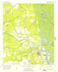
(10)- 1953 Map of Hardeeville
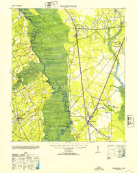 1953 Hardeeville1953 Print · USGSThe riverfront and rail corridors of the South Carolina lowcountry are frozen in time just after the war. Researchers can trace the timber industry through sites like Ebenezer Log, locate the old Okatie Club, or find the Indian Mound near Purrysburg.
 - 1955 Map of Pritchardville, 1956 Print
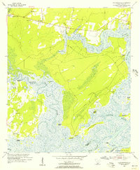 1955 Pritchardville1956 Print · USGSThe Beaufort and Jasper County Lowcountry comes alive in this mid-fifties survey of the tidal rivers and marshes before modern development. Genealogists can trace family landmarks like St Matthews Ch, Moreland Cem, and the many Abandoned Rice Fields lining the New River.4 unique versions available
 - 1955 Map of Savannah Beach North, 1956 Print
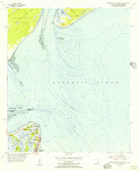 1955 Savannah Beach North1956 Print · USGSThe coastal border of South Carolina and Georgia comes alive in the mid-1950s, detailing the shifting sands and maritime defenses of the Atlantic coast. Researchers can trace the military grounds of Fort Screven or locate the historic Tybee Lighthouse and the small Cem on Tybee Island.3 unique versions available
 - 1955 Map of Fort Pulaski, 1957 Print
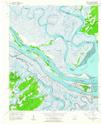 1955 Fort Pulaski1957 Print · USGSCoastal South Carolina and Georgia meet at the mouth of the Savannah River in the mid-fifties, where salt marshes and tidal islands define the border. Researchers can trace historic family sites on Daufuskie Island like Mary Field Cem or locate the Lighthouse (Abandoned) near Fort Pulaski.2 unique versions available
 - 1955 Map of Port Wentworth, 1957 Print
 1955 Port Wentworth1957 Print · USGSCoastal Georgia at the mid-century reveals a complex landscape of river commerce and expanding rail networks north of Savannah. Genealogists and historians can trace family-named sites like Meinhard, Cherokee Hill Cem, and the old Goshen Ch as they appeared before modern development.2 unique versions available
 - 1955 Map of Limehouse, 1957 Print
 1955 Limehouse1957 Print · USGSJasper County and the Savannah River marshes are captured here in the mid-fifties, showing a landscape of coastal wetlands and rural hamlets. Genealogists can locate family landmarks like Williams Cem and Allen Cem, or trace the rail routes of the Atlantic Coast Line.2 unique versions available
 - 1955 Map of Savannah, 1957 Print
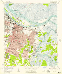 1955 Savannah1957 Print · USGSMid-century Savannah is shown in detail as it expands from its riverfront core into residential neighborhoods and across tidal marshes. Genealogists and historians can trace family locations through established areas like Ardsley Park, numerous local schools, and prominent sites like Bonaventure Cemetery or the Hunter Air Force Base.3 unique versions available
 - 1957 Map of Savannah, 1967 Print
 1957 Savannah1967 Print · USGSThe Lowcountry and Georgia coastal plain are shown here in the late fifties, prior to modern expansion. Researchers can trace the rail-and-river economy through the Central of Georgia lines and the Ogeechee River wetlands.4 unique versions available
 - 1958 Map of Jasper, 1960 Print
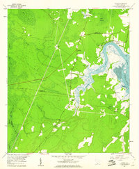 1958 Jasper1960 Print · USGSThe South Carolina Lowcountry shows its mid-century character as tidal waters and rural settlements meet. Trace family roots at Jaxville Cem, Pinckney Colony, and riverfront sites like Baileys Landing.3 unique versions available
 - 1958 Map of Spring Island, 1961 Print
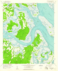 1958 Spring Island1961 Print · USGSThe Beaufort sea islands are captured in the late 1950s, showing a coastal landscape still defined by its tidal creeks and small landings. Researchers can trace historical sites like St Lukes Ch, Fripp Landing, and the marshy expanses of Spring Island.4 unique versions available
End of results
Showing maps 1-10 of 10
Top cities of Jasper County
Frequently asked questions
- What are the different types of historical maps available for Jasper County?
- What is the oldest map of Jasper County?
- Where can I purchase historical maps of Jasper County for my home or office?
- Where can I download high-res historical maps of Jasper County?
- Are there historical topographic maps available for Jasper County?
- Is there historical aerial imagery available for Jasper County?
- Where are historical maps of Jasper County sourced from?